FAA INFORMATION EFFECTIVE 16 APRIL 2026
Location
| FAA Identifier: | GAS |
| Lat/Long: | 38-50-02.8015N 082-09-48.3474W
38-50.046692N 082-09.805790W
38.8341115,-82.1634298
(estimated) |
| Elevation: | 565.9 ft. / 172 m (estimated) |
| Variation: | 07W (2000) |
| From city: | 2 miles NE of GALLIPOLIS, OH |
| Time zone: | UTC -4 (UTC -5 during Standard Time) |
| Zip code: | 45631 |
Airport Operations
| Airport use: | Open to the public |
| Control tower: | no |
| ARTCC: | INDIANAPOLIS CENTER |
| FSS: | DAYTON FLIGHT SERVICE STATION |
| NOTAMs facility: | DAY (NOTAM-D service available) |
| Attendance: | MON-FRI 0900-1700
UNATNDD THANKSGIVING, CHRISTMAS, & NEW YEARS DAY. |
| Wind indicator: | lighted |
| Segmented circle: | no |
| Lights: | ACTVT REIL RWY 23; PAPI RWY 05 & 23; MIRL RWY 05/23 - CTAF. |
| Beacon: | white-green (lighted land airport)
Operates sunset to sunrise. |
Airport Communications
| CTAF/UNICOM: | 123.0 |
| WX AWOS-3PT: | 119.925 (740-446-2149) |
| HUNTINGTON APPROACH: | 128.4 |
| HUNTINGTON DEPARTURE: | 128.4 |
| CLEARANCE DELIVERY: | 124.55 |
| WX AWOS-3 at 3I2 (6 nm NE): | 119.675 (304-675-4618) |
| WX AWOS-2 at I18 (17 nm E): | 121.3 (304-273-3424) |
Nearby radio navigation aids
| VOR radial/distance | | VOR name | | Freq | | Var |
|---|
| HVQr331/34.4 | | CHARLESTON VOR/DME | | 117.40 | | 03W |
| NDB name | | Hdg/Dist | | Freq | | Var | | ID |
|---|
| UNIVERSITY | | 190/25.4 | | 250 | | 06W | | UGS | ..- --. ... |
Airport Services
| Fuel available: | 100LL JET-A1
100LL:100LL & A1 AVBL H24 SELF SER VIA CREDIT CARD. |
| Parking: | tiedowns |
| Airframe service: | NONE |
| Powerplant service: | NONE |
| Bottled oxygen: | NONE |
| Bulk oxygen: | NONE |
Runway Information
Runway 5/23
| Dimensions: | 3999 x 75 ft. / 1219 x 23 m |
| Surface: | asphalt/grooved, in good condition |
| Weight bearing capacity: | |
| Runway edge lights: | medium intensity |
| RUNWAY 5 | | RUNWAY 23 |
| Latitude: | 38-49.825773N | | 38-50.267597N |
| Longitude: | 082-10.118150W | | 082-09.493397W |
| Elevation: | 561.0 ft. | | 560.6 ft. |
| Traffic pattern: | left | | left |
| Runway heading: | 055 magnetic, 048 true | | 235 magnetic, 228 true |
| Markings: | nonprecision, in good condition | | nonprecision, in good condition |
| Visual slope indicator: | 2-light PAPI on left (3.00 degrees glide path) | | 2-light PAPI on left (3.00 degrees glide path) |
| Runway end identifier lights: | | | yes |
| Touchdown point: | yes, no lights | | yes, no lights |
| Obstructions: | 45 ft. tree, 660 ft. from runway, 213 ft. left of centerline, 10:1 slope to clear
+10 FT ROAD, 170 FT DIST, L/R OF CNTRLN. | | 10 ft. tree, 205 ft. from runway
+5-17 FT TREES, 5-145 FT DIST, 75-181 FT L. |
Airport Ownership and Management from official FAA records
| Ownership: | Publicly-owned |
| Owner: | GALLIA COUNTY COMMISSIONERS
18 LOCUST ST
GALLIPOLIS, OH 45631-1292
Phone 740-446-4374
GCBOC@GALLIANET.NET. |
| Manager: | KALEB ARMS
312 AIRPORT RD
GALLIPOLIS, OH 45631
Phone 740-446-9004
KARMS@GALLIANET.NET. |
Additional Remarks
| - | DEER & BIRDS ON & INVOF ARPT. |
| - | PARL TWY HAS LRG CRACKS & LOOSE GRVL. |
| - | FOR CD CTC HUNTINGTON ATCT AT 304-453-2490. |
Instrument Procedures
NOTE: All procedures below are presented as PDF files. If you need a reader for these files, you should download the free Adobe Reader.NOT FOR NAVIGATION. Please procure official charts for flight.
FAA instrument procedures published for use from 16 April 2026 at 0901Z to 14 May 2026 at 0900Z.
IAPs - Instrument Approach Procedures |
|---|
| RNAV (GPS) RWY 23 | |
download (205KB) |
| NOTE: Special Take-Off Minimums/Departure Procedures apply | |
download (366KB) |
Other nearby airports with instrument procedures:
3I2 - Mason County Airport (6 nm NE)
I18 - Jackson County Airport (17 nm E)
KJRO - James A Rhodes Airport (21 nm NW)
KUNI - Ohio University Airport (23 nm N)
12V - Ona Airpark (24 nm S)
|
|

Road maps at:
MapQuest
Bing
Google
| Aerial photo |
|---|
WARNING: Photo may not be current or correct
 Photo by Joseph DeRosa
Photo taken 04-Oct-2011
looking northeast.
Photo by Joseph DeRosa
Photo taken 04-Oct-2011
looking northeast.
Do you have a better or more recent aerial photo of Gallia-Meigs Regional Airport that you would like to share? If so, please send us your photo.
|
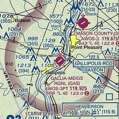
| Sectional chart |
|---|
|
| Airport distance calculator |
|---|
|
|
| Sunrise and sunset |
|---|
|
Times for 03-May-2026
| | Local
(UTC-4) | | Zulu
(UTC) |
|---|
| Morning civil twilight | | 06:01 | | 10:01 |
| Sunrise | | 06:30 | | 10:30 |
| Sunset | | 20:22 | | 00:22 |
| Evening civil twilight | | 20:50 | | 00:50 |
|
| Current date and time |
|---|
| Zulu (UTC) | 03-May-2026 15:20:27 |
|---|
| Local (UTC-4) | 03-May-2026 11:20:27 |
|---|
|
| TAF |
|---|
KHTS
33nm SW | 031125Z 0312/0412 VRB04KT P6SM SKC FM031900 24006KT P6SM FEW230 FM040300 20004KT P6SM BKN060
|
KCRW
38nm SE | 031125Z 0312/0412 VRB03KT P6SM SKC FM031600 28007KT P6SM FEW250 FM040200 00000KT P6SM BKN160 FM040800 VRB03KT P6SM BKN070
|
|
| NOTAMs |
|---|
NOTAMs are issued by the DoD/FAA and will open in a separate window not controlled by AirNav.
|
|


