FAA INFORMATION EFFECTIVE 14 MAY 2026
Location
| FAA Identifier: | GVQ |
| Lat/Long: | 43-01-54.3000N 078-10-10.8000W
43-01.905000N 078-10.180000W
43.0317500,-78.1696667
(estimated) |
| Elevation: | 913.5 ft. / 278.4 m (surveyed) |
| Variation: | 11W (2000) |
| From city: | 2 miles N of BATAVIA, NY |
| Time zone: | UTC -4 (UTC -5 during Standard Time) |
| Zip code: | 14020 |
Airport Operations
| Airport use: | Open to the public |
| Control tower: | no |
| ARTCC: | CLEVELAND CENTER |
| FSS: | BUFFALO FLIGHT SERVICE STATION |
| NOTAMs facility: | GVQ (NOTAM-D service available) |
| Attendance: | APR-OCT 0730-2000, NOV-MAR 0730-1830
FOR AFTR HRS ATNDT, CALL 585-344-8532 DURG ATND HRS. CALL IN FEE. |
| Wind indicator: | lighted |
| Segmented circle: | yes |
| Lights: | ACTVT MALSR RWY 28; REIL RWY 10; PAPI RWY 10 & 28; HIRL RWY 10/28 - CTAF. |
| Beacon: | white-green (lighted land airport)
Operates sunset to sunrise. |
Airport Communications
| CTAF/UNICOM: | 122.7 |
| WX AWOS-3PT: | 127.525 (585-343-6369) |
| ROCHESTER APPROACH: | 123.7 |
| ROCHESTER DEPARTURE: | 123.7 |
| CLEARANCE DELIVERY: | 121.8 |
| WX AWOS-2 at 01G (18 nm S): | 118.525 (585-237-0235) |
Nearby radio navigation aids
| VOR radial/distance | | VOR name | | Freq | | Var |
|---|
| ROCr269/22.4 | | ROCHESTER VOR/DME | | 110.00 | | 12W |
| GEEr311/22.6 | | GENESEO VOR/DME | | 108.20 | | 09W |
Airport Services
| Fuel available: | 100LL JET-A1+ |
| Parking: | hangars and tiedowns |
| Airframe service: | MAJOR |
| Powerplant service: | MAJOR |
| Bottled oxygen: | NONE |
| Bulk oxygen: | HIGH |
Runway Information
Runway 10/28
| Dimensions: | 5499 x 100 ft. / 1676 x 30 m |
| Surface: | asphalt/grooved, in fair condition |
| Weight bearing capacity: | | Single wheel: | 21.0 | | Double wheel: | 33.0 |
|
| Runway edge lights: | high intensity |
| RUNWAY 10 | | RUNWAY 28 |
| Latitude: | 43-01.911777N | | 43-01.898603N |
| Longitude: | 078-10.796413W | | 078-09.562533W |
| Elevation: | 911.6 ft. | | 910.6 ft. |
| Traffic pattern: | left | | left |
| Runway heading: | 102 magnetic, 091 true | | 282 magnetic, 271 true |
| Markings: | nonprecision, in fair condition | | precision, in fair condition |
| Visual slope indicator: | 2-light PAPI on left (3.00 degrees glide path) | | 2-light PAPI on left (3.00 degrees glide path) |
| Approach lights: | | | MALSR: 1,400 foot medium intensity approach lighting system with runway alignment indicator lights |
| Runway end identifier lights: | yes | | no |
| Touchdown point: | yes, no lights | | yes, no lights |
| Instrument approach: | | | ILS |
| Obstructions: | 8 ft. fence, lighted, 200 ft. from runway, 460 ft. right of centerline
8 FT FENCE, 0-199 FT DSTC, 460 FT R. | | none |
Airport Ownership and Management from official FAA records
| Ownership: | Publicly-owned |
| Owner: | GENESEE COUNTY
GENESEE CO. SUPT. OF HWY., 153 CEDAR STREET
BATAVIA, NY 14020
Phone 585-344-8508 |
| Manager: | JASON LONG
4701 E. SAILE DRIVE
BATAVIA, NY 14020
Phone 585-344-8532 |
Additional Remarks
| - | RWY 10: 5 FT BERM 220 FT N, 1600-2200 FT E OF RWY 10 END. |
| - | FOR CD CTC CLEVELAND ARTCC AT 440-774-0490. |
Instrument Procedures
NOTE: All procedures below are presented as PDF files. If you need a reader for these files, you should download the free Adobe Reader.NOT FOR NAVIGATION. Please procure official charts for flight.
FAA instrument procedures published for use from 14 May 2026 at 0901Z to 11 June 2026 at 0900Z.
IAPs - Instrument Approach Procedures |
|---|
| ILS OR LOC RWY 28 | |
download (295KB) |
| RNAV (GPS) RWY 10 | |
download (182KB) |
| RNAV (GPS) RWY 28 | |
download (273KB) |
| VOR/DME-A | |
download (187KB) |
| NOTE: Special Alternate Minimums apply | |
download (122KB) |
| NOTE: Special Take-Off Minimums/Departure Procedures apply | |
download (150KB) |
Other nearby airports with instrument procedures:
9G6 - Pine Hill Airport (10 nm NW)
5G0 - Le Roy Airport (11 nm E)
9G3 - Akron Airport/Jesson Field (14 nm W)
7G0 - Ledgedale Airpark (14 nm NE)
KBQR - Buffalo-Lancaster Regional Airport (21 nm W)
|
|

Road maps at:
MapQuest
Bing
Google
| Aerial photo |
|---|
WARNING: Photo may not be current or correct
 Photo taken 26-Nov-2006
view from the south, taken from a Commander 114 on a left downwind for 28
Photo taken 26-Nov-2006
view from the south, taken from a Commander 114 on a left downwind for 28
Do you have a better or more recent aerial photo of Genesee County Airport that you would like to share? If so, please send us your photo.
|
| Sectional chart |
|---|
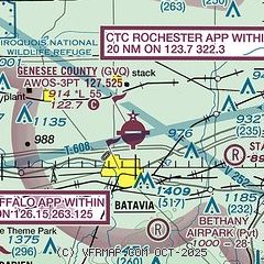
|
| Airport distance calculator |
|---|
|
|
| Sunrise and sunset |
|---|
|
Times for 24-May-2026
| | Local
(UTC-4) | | Zulu
(UTC) |
|---|
| Morning civil twilight | | 05:08 | | 09:08 |
| Sunrise | | 05:42 | | 09:42 |
| Sunset | | 20:37 | | 00:37 |
| Evening civil twilight | | 21:11 | | 01:11 |
|
| Current date and time |
|---|
| Zulu (UTC) | 24-May-2026 07:21:27 |
|---|
| Local (UTC-4) | 24-May-2026 03:21:27 |
|---|
|
| METAR |
|---|
| KGVQ | 240656Z AUTO 16010G17KT 10SM BKN018 OVC035 11/08 A3014 RMK AO2 SLP206 T01060078
|
|
| TAF |
|---|
KROC
22nm E | 240520Z 2406/2506 15012G22KT P6SM -SHRA OVC025 FM240700 14011G19KT P6SM OVC015 TEMPO 2407/2410 4SM -SHRA OVC010 FM241000 15010G21KT P6SM OVC020 FM250100 16007KT 6SM -SHRA OVC020 FM250400 17006KT 4SM -SHRA OVC015
|
KBUF
25nm W | 240520Z 2406/2506 15008KT P6SM OVC020 TEMPO 2406/2410 SCT020 BKN050 FM241800 21008KT P6SM BKN020 PROB30 2422/2424 4SM -SHRA OVC015 FM250000 VRB03KT 5SM -SHRA BKN020 FM250400 18005KT 6SM -SHRA OVC015 FM250500 18004KT 6SM BR OVC012 PROB30 2505/2506 4SM -SHRA OVC008
|
|
| NOTAMs |
|---|
NOTAMs are issued by the DoD/FAA and will open in a separate window not controlled by AirNav.
|
|


