FAA INFORMATION EFFECTIVE 16 APRIL 2026
Location
| FAA Identifier: | HOC |
| Lat/Long: | 39-11-19.5408N 083-32-19.6495W
39-11.325680N 083-32.327492W
39.1887613,-83.5387915
(estimated) |
| Elevation: | 977.3 ft. / 297.9 m (surveyed) |
| Variation: | 05W (1990) |
| From city: | 3 miles SE of HILLSBORO, OH |
| Time zone: | UTC -4 (UTC -5 during Standard Time) |
| Zip code: | 45133 |
Airport Operations
| Airport use: | Open to the public |
| Control tower: | no |
| ARTCC: | INDIANAPOLIS CENTER |
| FSS: | DAYTON FLIGHT SERVICE STATION |
| NOTAMs facility: | DAY (NOTAM-D service available) |
| Attendance: | 0800-1700 |
| Pattern altitude: | 1677.3 ft. MSL |
| Wind indicator: | lighted |
| Segmented circle: | no |
| Lights: | ACTVT REIL RWY 05 & 23; PAPI RWY 23; MIRL RWY 05/23 - CTAF. |
| Beacon: | white-green (lighted land airport)
Operates sunset to sunrise. |
Airport Communications
| CTAF/UNICOM: | 123.05 |
| WX AWOS-3: | 118.175 (937-393-9038) |
| WX ASOS at ILN (19 nm NW): | PHONE 937-383-7334 |
- APCH/DEP SVC PRVDD BY INDIANAPOLIS ARTCC ON FREQS 135.575/290.5 (PORTSMOUTH RCAG).
Nearby radio navigation aids
| VOR radial/distance | | VOR name | | Freq | | Var |
|---|
| MXQr144/18.9 | | MIDWEST VOR/DME | | 112.90 | | 04W |
| XUBr237/(33.0) | | YELLOW BUD VOR | | 112.50 | | 05W |
| NDB name | | Hdg/Dist | | Freq | | Var | | ID |
|---|
| COURT HOUSE | | 201/25.7 | | 414 | | 06W | | CSS | -.-. ... ... |
| SPORTYS | | 082/32.2 | | 245 | | 04W | | PWF | .--. .-- ..-. |
Airport Services
| Fuel available: | 100LL
100LL:AVBL H24 SELF SVC VIA CREDIT CARD. |
| Parking: | hangars and tiedowns |
| Airframe service: | MAJOR |
| Powerplant service: | MAJOR |
| Bottled oxygen: | NONE |
| Bulk oxygen: | NONE |
Runway Information
Runway 5/23
| Dimensions: | 3520 x 75 ft. / 1073 x 23 m |
| Surface: | asphalt, in good condition |
| Weight bearing capacity: | |
| Runway edge lights: | medium intensity |
| RUNWAY 5 | | RUNWAY 23 |
| Latitude: | 39-11.136602N | | 39-11.514748N |
| Longitude: | 083-32.609857W | | 083-32.045102W |
| Elevation: | 977.3 ft. | | 930.9 ft. |
| Traffic pattern: | left | | left |
| Runway heading: | 054 magnetic, 049 true | | 234 magnetic, 229 true |
| Markings: | nonprecision, in good condition | | nonprecision, in good condition |
| Visual slope indicator: | | | 2-light PAPI on left (4.00 degrees glide path) |
| Runway end identifier lights: | yes | | yes |
| Touchdown point: | yes, no lights | | yes, no lights |
| Obstructions: | 25 ft. trees, 418 ft. from runway, 176 ft. right of centerline, 8:1 slope to clear | | 50 ft. trees, 903 ft. from runway, 282 ft. right of centerline, 14:1 slope to clear
+50 TREE, 81 FT DIST, 139 FT R; +5-15 FT TREES & BRUSH, 160 FT DIST, 250 FT L/R. |
Airport Ownership and Management from official FAA records
| Ownership: | Publicly-owned |
| Owner: | HIGHLAND COUNTY COMMISSIONERS
HIGHLAND COUNTY COURTHOUSE
HILLSBORO, OH 45133
Phone 937-393-9112 |
| Manager: | BOB PROSEK, AIRPORT AUTH PRESIDENT
9500 N SHORE DR
HILLSBORO, OH 45133-7799
Phone 937-393-9112 |
Additional Remarks
| - | DEER & BIRDS ON & INVOF ARPT. |
| - | FOR CD IF UNA TO CTC ON FSS FREQ, CTC INDIANAPOLIS ARTCC AT 317-247-2411. |
Instrument Procedures
NOTE: All procedures below are presented as PDF files. If you need a reader for these files, you should download the free Adobe Reader.NOT FOR NAVIGATION. Please procure official charts for flight.
FAA instrument procedures published for use from 16 April 2026 at 0901Z to 14 May 2026 at 0900Z.
IAPs - Instrument Approach Procedures |
|---|
| RNAV (GPS) RWY 23 | |
download (247KB) |
| NOTE: Special Take-Off Minimums/Departure Procedures apply | |
download (276KB) |
Other nearby airports with instrument procedures:
KILN - Wilmington Air Park (19 nm NW)
KAMT - Alexander Salamon Airport (20 nm S)
I23 - Fayette County Airport (24 nm N)
I66 - Clinton Field Airport (24 nm NW)
KGEO - Brown County Airport (24 nm SW)
|
|

Road maps at:
MapQuest
Bing
Google
| Aerial photo |
|---|
WARNING: Photo may not be current or correct
 Photo courtesy of AirNav, LLC
Photo taken 24-Aug-2014
looking east.
Photo courtesy of AirNav, LLC
Photo taken 24-Aug-2014
looking east.
Do you have a better or more recent aerial photo of Highland County Airport that you would like to share? If so, please send us your photo.
|
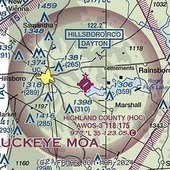
| Sectional chart |
|---|
|
| Airport distance calculator |
|---|
|
|
| Sunrise and sunset |
|---|
|
Times for 01-May-2026
| | Local
(UTC-4) | | Zulu
(UTC) |
|---|
| Morning civil twilight | | 06:08 | | 10:08 |
| Sunrise | | 06:37 | | 10:37 |
| Sunset | | 20:26 | | 00:26 |
| Evening civil twilight | | 20:55 | | 00:55 |
|
| Current date and time |
|---|
| Zulu (UTC) | 01-May-2026 21:14:24 |
|---|
| Local (UTC-4) | 01-May-2026 17:14:24 |
|---|
|
| METAR |
|---|
KILN
19nm NW | 012054Z AUTO 34012KT 10SM FEW030 OVC040 10/03 A2998 RMK AO2 PK WND 35026/1957 SLP163 T01000028 51018
|
KI23
24nm N | 012055Z AUTO 31017G21KT 10SM FEW023 FEW028 OVC037 09/04 A2997 RMK AO2
|
KRZT
28nm NE | 012051Z AUTO 32011KT 10SM BKN033 BKN039 10/03 A2998 RMK AO2
|
KEOP
28nm E | 012055Z AUTO 33014G21KT 10SM SCT040 SCT055 BKN070 12/05 A2993 RMK AO2
|
KI69
32nm W | 012056Z AUTO 34010G18KT 10SM SCT045 BKN050 12/02 A2998 RMK AO1 T01220015
|
KI68
37nm NW | 012055Z AUTO 33009KT 10SM BKN060 OVC070 11/06 A2998 RMK AO2
|
|
| TAF |
|---|
KILN
19nm NW | 011727Z 0118/0218 32014G22KT P6SM BKN040 TEMPO 0118/0120 BKN025 FM020000 30007KT P6SM SCT040 FM020400 33004KT P6SM FEW250 FM021400 34007KT P6SM SCT050 FM021500 33010KT P6SM BKN050
|
|
| NOTAMs |
|---|
NOTAMs are issued by the DoD/FAA and will open in a separate window not controlled by AirNav.
|
|


