FAA INFORMATION EFFECTIVE 27 NOVEMBER 2025
Location
| FAA Identifier: | HYI |
| Lat/Long: | 29-53-33.9000N 097-51-46.8000W
29-53.565000N 097-51.780000W
29.8927500,-97.8630000
(estimated) |
| Elevation: | 594.7 ft. / 181.3 m (surveyed) |
| Variation: | 07E (1985) |
| From city: | 31 miles S of AUSTIN, TX |
| Time zone: | UTC -6 (UTC -5 during Daylight Saving Time) |
| Zip code: | 78656 |
Airport Operations
| Airport use: | Open to the public |
| Activation date: | 05/1965 |
| Control tower: | yes |
| ARTCC: | HOUSTON CENTER |
| FSS: | SAN ANGELO FLIGHT SERVICE STATION |
| NOTAMs facility: | HYI (NOTAM-D service available) |
| Attendance: | 0700-2100
FOR AFT HRS SVC 800-229-2379. |
| Wind indicator: | lighted |
| Segmented circle: | yes |
| Lights: | ACTVT MALS RWY 13; MIRL RWYS 08/26, 13/31 & 17/35 PRESET LOW INTST, TO INCR INTST - CTAF. PAPI RWYS 13, 31, 17 OPR CONSLY. |
| Beacon: | white-green (lighted land airport)
Operates sunset to sunrise. |
Airport Communications
| CTAF: | 126.825 |
| ATIS: | 120.825 |
| WX AWOS-3PT: | PHONE 512-353-8005 |
| SAN MARCOS GROUND: | 120.125 [0700-2100 EFF 01 APR 2021] |
| SAN MARCOS TOWER: | 126.825 [0700-2100 EFF 01 APR 2021] |
| AUSTIN APPROACH: | 119.0 |
| AUSTIN DEPARTURE: | 119.0 |
| CLEARANCE DELIVERY: | 121.35 ;WHEN HYI TWR CLSD 120.125 |
| AEROZ DP: | 119.0 |
| BLEWE STAR: | 127.225 |
| BNDIA DP: | 119.0 |
| ELOEL DP: | 119.0 |
| GABOO STAR: | 127.225 |
| ILEXY DP: | 119.0 |
| MUCKY DP: | 119.0 |
| POTRR STAR: | 127.225 |
| SAYBR DP: | 119.0 |
| SZAGI STAR: | 118.15 ;SFC-7000 FT 119.0 ;8,000-12,000 FT |
| WX ASOS at BAZ (15 nm SW): | 119.325 (830-629-7979) |
Nearby radio navigation aids
| VOR radial/distance | | VOR name | | Freq | | Var |
|---|
| RNDr039/31.4 | | RANDOLPH VORTAC | | 112.30 | | 05E |
| CWKr205/33.9 | | CENTEX VORTAC | | 112.80 | | 06E |
| SATr056/34.6 | | SAN ANTONIO VORTAC | | 116.80 | | 08E |
| NDB name | | Hdg/Dist | | Freq | | Var | | ID |
|---|
| GARYS | | 124/6.0 | | 272 | | 07E | | RU | .-. ..- |
Airport Services
| Fuel available: | 100LL JET-A
100LL:100LL SELF SVC; 100 LL & JET A AVBL FULL SERVE. |
| Parking: | hangars and tiedowns |
| Airframe service: | MAJOR |
| Bottled oxygen: | LOW |
| Bulk oxygen: | LOW |
Runway Information
Runway 8/26
| Dimensions: | 6330 x 100 ft. / 1929 x 30 m |
| Surface: | asphalt, in good condition |
| Weight bearing capacity: | |
| Runway edge lights: | medium intensity |
| RUNWAY 8 | | RUNWAY 26 |
| Latitude: | 29-53.508392N | | 29-53.547513N |
| Longitude: | 097-52.624925W | | 097-51.427320W |
| Elevation: | 587.8 ft. | | 580.0 ft. |
| Traffic pattern: | left | | left |
| Runway heading: | 081 magnetic, 088 true | | 261 magnetic, 268 true |
| Markings: | nonprecision, in fair condition | | nonprecision, in fair condition |
| Touchdown point: | yes, no lights | | yes, no lights |
| Obstructions: | 6 ft. fence, 201 ft. from runway, 360 ft. left of centerline
6 FT FENCE 130-199 FT DSTC, 360 FT L. | | 8 ft. crops, 205 ft. from runway |
Runway 13/31
| Dimensions: | 5601 x 100 ft. / 1707 x 30 m |
| Surface: | asphalt, in good condition |
| Weight bearing capacity: | |
| Runway edge lights: | medium intensity |
| RUNWAY 13 | | RUNWAY 31 |
| Latitude: | 29-53.821778N | | 29-53.192992N |
| Longitude: | 097-52.201297W | | 097-51.424175W |
| Elevation: | 593.1 ft. | | 573.4 ft. |
| Traffic pattern: | left | | left |
| Runway heading: | 126 magnetic, 133 true | | 306 magnetic, 313 true |
| Markings: | precision, in good condition | | precision, in good condition |
| Visual slope indicator: | 2-light PAPI on left (3.00 degrees glide path) | | 2-light PAPI on left (3.00 degrees glide path) |
| Approach lights: | MALS: 1,400 foot medium intensity approach lighting system | | |
| Touchdown point: | yes, no lights | | yes, no lights |
| Instrument approach: | ILS | | |
| Obstructions: | none | | 64 ft. trees, 2200 ft. from runway, 31:1 slope to clear |
Runway 17/35
| Dimensions: | 5214 x 100 ft. / 1589 x 30 m |
| Surface: | asphalt, in good condition |
| Weight bearing capacity: | |
| Runway edge lights: | medium intensity |
| RUNWAY 17 | | RUNWAY 35 |
| Latitude: | 29-54.101250N | | 29-53.241648N |
| Longitude: | 097-51.465007W | | 097-51.428330W |
| Elevation: | 594.5 ft. | | 575.0 ft. |
| Traffic pattern: | left | | left |
| Runway heading: | 171 magnetic, 178 true | | 351 magnetic, 358 true |
| Markings: | nonprecision, in fair condition | | nonprecision, in fair condition |
| Visual slope indicator: | 2-light PAPI on left (3.00 degrees glide path) | | |
| Touchdown point: | yes, no lights | | yes, no lights |
Airport Ownership and Management from official FAA records
| Ownership: | Publicly-owned |
| Owner: | CITY OF SAN MARCOS
630 E. HOPKINS STREET
SAN MARCOS, TX 78666
Phone 512-216-6039 |
| Manager: | CASSIDY BERENATO
4400 HWY 21, SUITE 200
SAN MARCOS, TX 78666
Phone 512-216-6039
EMERG CTC: CITY OF SAN MARCOS POLICE DISPATCH - 512-753-2108 |
Additional Remarks
| - | FOR CD CTC AUSTIN APCH AT 512-369-7865. |
| - | APN ALL IREG SFC. |
| - | BIRDS AND WILDLIFE ON AND INVOF ARPT. |
Instrument Procedures
NOTE: All procedures below are presented as PDF files. If you need a reader for these files, you should download the free Adobe Reader.NOT FOR NAVIGATION. Please procure official charts for flight.
FAA instrument procedures published for use from 27 November 2025 at 0901Z to 25 December 2025 at 0900Z.
STARs - Standard Terminal Arrivals |
|---|
| BLEWE FIVE | |
download (157KB) |
| GABOO ONE (RNAV) | |
download (127KB) |
| POTRR TWO (RNAV) | |
download (165KB) |
| SZAGI THREE (RNAV) | |
download (196KB) |
IAPs - Instrument Approach Procedures |
|---|
| ILS OR LOC RWY 13 **CHANGED** | |
download (272KB) |
| RNAV (GPS) RWY 08 **CHANGED** | |
download (252KB) |
| RNAV (GPS) RWY 13 **CHANGED** | |
download (230KB) |
| RNAV (GPS) RWY 17 **CHANGED** | |
download (247KB) |
| RNAV (GPS) RWY 26 **CHANGED** | |
download (252KB) |
| RNAV (GPS) RWY 31 **CHANGED** | |
download (257KB) |
| RNAV (GPS) RWY 35 **CHANGED** | |
download (247KB) |
| NDB RWY 13 **CHANGED** | |
download (210KB) |
| NOTE: Special Alternate Minimums apply | |
download (116KB) |
Departure Procedures |
|---|
| AEROZ TWO (RNAV) | |
download (239KB) |
| BNDIA THREE (RNAV) | |
download (231KB) |
| ELOEL THREE (RNAV) | |
download (249KB) |
| ILEXY FOUR (RNAV) | |
download (266KB) |
| MUCKY THREE (RNAV) | |
download (226KB) |
| SAYBR THREE (RNAV) | |
download (235KB) |
| NOTE: Special Take-Off Minimums/Departure Procedures apply | |
download (504KB) |
Other nearby airports with instrument procedures:
50R - Lockhart Municipal Airport (10 nm E)
KBAZ - New Braunfels National Airport (15 nm SW)
KAUS - Austin-Bergstrom International Airport (21 nm NE)
3R9 - Lakeway Airpark (29 nm N)
KRND - Randolph Air Force Base (31 nm SW)
|
|

Road maps at:
MapQuest
Bing
Google
| Aerial photo |
|---|
WARNING: Photo may not be current or correct
 Photo by Charlie Thompson
Photo taken 02-Apr-2016
looking northwest.
Photo by Charlie Thompson
Photo taken 02-Apr-2016
looking northwest.
Do you have a better or more recent aerial photo of San Marcos Regional Airport that you would like to share? If so, please send us your photo.
|
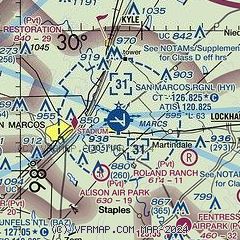
| Sectional chart |
|---|
|
CAUTION: Diagram may not be current

| Airport distance calculator |
|---|
|
|
| Sunrise and sunset |
|---|
|
Times for 15-Dec-2025
| | Local
(UTC-6) | | Zulu
(UTC) |
|---|
| Morning civil twilight | | 06:54 | | 12:54 |
| Sunrise | | 07:21 | | 13:21 |
| Sunset | | 17:33 | | 23:33 |
| Evening civil twilight | | 17:59 | | 23:59 |
|
| Current date and time |
|---|
| Zulu (UTC) | 15-Dec-2025 17:05:06 |
|---|
| Local (UTC-6) | 15-Dec-2025 11:05:06 |
|---|
|
| METAR |
|---|
| KHYI | 151656Z 30003KT 10SM FEW030 08/M06 A3050 RMK AO2 SLP329 T00781056 $
|
KBAZ
14nm SW | 151651Z 00000KT 10SM CLR 07/M05 A3048 RMK AO2 SLP322 T00721050
|
KSEQ
20nm S | 151655Z AUTO 06003KT 10SM CLR 07/M05 A3046 RMK AO2 SLP319 T00681052
|
|
| NOTAMs |
|---|
NOTAMs are issued by the DoD/FAA and will open in a separate window not controlled by AirNav.
|
|


