FAA INFORMATION EFFECTIVE 15 MAY 2025
Location
| FAA Identifier: | JOT |
| Lat/Long: | 41-31-03.8690N 088-10-31.4300W
41-31.064483N 088-10.523833W
41.5177414,-88.1753972
(estimated) |
| Elevation: | 582.3 ft. / 177.5 m (surveyed) |
| Variation: | 03W (2010) |
| From city: | 4 miles W of JOLIET, IL |
| Time zone: | UTC -5 (UTC -6 during Standard Time) |
| Zip code: | 60431 |
Airport Operations
| Airport use: | Open to the public |
| Activation date: | 04/1940 |
| Control tower: | no |
| ARTCC: | CHICAGO CENTER |
| FSS: | KANKAKEE FLIGHT SERVICE STATION |
| NOTAMs facility: | JOT (NOTAM-D service available) |
| Attendance: | SUN UNATND, ALL MON-FRI 0700-1800, ALL SAT 0700-1300 |
| Wind indicator: | lighted |
| Segmented circle: | no |
| Lights: | MIRL RY 13/31 PRESET ON LOW INTST - TO ACTVT INCR INTST PAPI RY 13; MIRL RY 13/31 - CTAF. |
| Beacon: | white-green (lighted land airport)
Operates sunset to sunrise. |
Airport Communications
| CTAF/UNICOM: | 122.7 |
| WX AWOS-3: | 119.975 (815-730-9560) |
| CHICAGO APPROACH: | 119.35 |
| CHICAGO DEPARTURE: | 119.35 |
| IC: | 119.35 |
| WX AWOS-3PT at LOT (6 nm NE): | 126.675 (815-588-4802) |
| WX AWOS-3 at C09 (12 nm SW): | 118.175 (815-941-1815) |
Nearby radio navigation aids
| VOR radial/distance | | VOR name | | Freq | | Var |
|---|
| JOTr103/6.6 | | JOLIET VOR/DME | | 112.30 | | 02E |
| EONr309/22.8 | | PEOTONE VORTAC | | 113.20 | | 02E |
| DPAr159/23.7 | | DUPAGE VOR/DME | | 114.55 | | 02E |
| CGTr269/27.1 | | CHICAGO HEIGHTS VORTAC | | 114.20 | | 02E |
Airport Services
| Fuel available: | 100LL JET-A MOGAS |
| Parking: | hangars and tiedowns |
| Airframe service: | MAJOR |
| Powerplant service: | MAJOR |
| Bottled oxygen: | NONE |
| Bulk oxygen: | NONE |
Runway Information
Runway 13/31
| Dimensions: | 2821 x 100 ft. / 860 x 30 m |
| Surface: | asphalt, in good condition |
| Weight bearing capacity: | |
| Runway edge lights: | medium intensity |
| RUNWAY 13 | | RUNWAY 31 |
| Latitude: | 41-31.185185N | | 41-30.907910N |
| Longitude: | 088-10.760513W | | 088-10.264570W |
| Elevation: | 580.5 ft. | | 577.4 ft. |
| Traffic pattern: | left | | left |
| Runway heading: | 130 magnetic, 127 true | | 310 magnetic, 307 true |
| Displaced threshold: | 100 ft. | | 80 ft. |
| Markings: | nonprecision, in fair condition | | nonprecision, in fair condition |
| Visual slope indicator: | 4-light PAPI on right (3.50 degrees glide path) | | |
| Runway end identifier lights: | no | | no |
| Touchdown point: | yes, no lights | | yes, no lights |
| Obstructions: | 44 ft. tree, 605 ft. from runway, 100 ft. left of centerline, 9:1 slope to clear
APCH RATIO 16:1 TO DTHR. | | 58 ft. tree, 690 ft. from runway, 1158 ft. right of centerline, 8:1 slope to clear
APCH RATIO 13:1 TO DTHR. |
Runway 4/22
| Dimensions: | 2552 x 150 ft. / 778 x 46 m |
| Surface: | turf, in good condition |
| Runway edge markings: | RWY 04 /22 MKD WITH TIRES PAINTED WHITE; THLD MKD WITH WHITE GRAVEL. |
| RUNWAY 4 | | RUNWAY 22 |
| Latitude: | 41-30.933602N | | 41-31.235038N |
| Longitude: | 088-10.731120W | | 088-10.341550W |
| Elevation: | 575.3 ft. | | 578.4 ft. |
| Traffic pattern: | left | | left |
| Runway heading: | 047 magnetic, 044 true | | 227 magnetic, 224 true |
| Runway end identifier lights: | no | | no |
| Touchdown point: | yes, no lights | | yes, no lights |
| Obstructions: | none | | 52 ft. tree, 673 ft. from runway, 145 ft. right of centerline, 12:1 slope to clear |
Airport Ownership and Management from official FAA records
| Ownership: | Publicly-owned |
| Owner: | JOLIET PARK DISTRICT
4000 W JEFFERSON
JOLIET, IL 60431
Phone 815-741-7275 |
| Manager: | JENNIFER MCFARLAND
4000 W JEFFERSON
JOLIET, IL 60431
Phone 815-741-7267 |
Additional Remarks
| - | FOR CD CTC CHICAGO APCH AT 847-289-0926. |
Instrument Procedures
There are no published instrument procedures at KJOT.
Some nearby airports with instrument procedures:
KLOT - Lewis University Airport (6 nm NE)
1C5 - Bolingbrook's Clow International Airport (11 nm N)
C09 - Morris Municipal Airport/James R Washburn Field (12 nm SW)
KARR - Aurora Municipal Airport (20 nm NW)
KDPA - DuPage Airport (24 nm N)
|
|

Road maps at:
MapQuest
Bing
Google
| Aerial photo |
|---|
WARNING: Photo may not be current or correct
 Photo taken 21-Aug-2011
looking west.
Photo taken 21-Aug-2011
looking west.
Do you have a better or more recent aerial photo of Joliet Regional Airport that you would like to share? If so, please send us your photo.
|
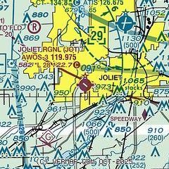
| Sectional chart |
|---|
|
| Airport distance calculator |
|---|
|
|
| Sunrise and sunset |
|---|
|
Times for 17-May-2025
| | Local
(UTC-5) | | Zulu
(UTC) |
|---|
| Morning civil twilight | | 05:01 | | 10:01 |
| Sunrise | | 05:33 | | 10:33 |
| Sunset | | 20:06 | | 01:06 |
| Evening civil twilight | | 20:37 | | 01:37 |
|
| Current date and time |
|---|
| Zulu (UTC) | 17-May-2025 18:54:32 |
|---|
| Local (UTC-5) | 17-May-2025 13:54:32 |
|---|
|
| METAR |
|---|
| KJOT | 171835Z AUTO 28009G19KT 250V330 10SM OVC046 19/07 A2971 RMK AO2 T01870074
|
KLOT
7nm NE | 171745Z 26020G27KT 10SM BKN040 17/08 A2970
|
KC09
12nm SW | 171835Z AUTO 30022G28KT 10SM BKN043 19/08 A2971 RMK AO2 T01860076
|
|
| TAF |
|---|
KDPA
24nm N | 171720Z 1718/1818 28016G26KT P6SM BKN040 FM180200 32009KT P6SM SCT035
|
KMDW
25nm NE | 171720Z 1718/1824 28016G26KT P6SM BKN045 FM180200 30009KT P6SM SCT035 FM181700 06010KT P6SM FEW040 SCT250
|
KORD
30nm N | 171720Z 1718/1824 28016G26KT P6SM BKN040 FM180200 30009KT P6SM SCT035 FM181800 05010KT P6SM FEW040 SCT250
|
|
| NOTAMs |
|---|
NOTAMs are issued by the DoD/FAA and will open in a separate window not controlled by AirNav.
|
|


