FAA INFORMATION EFFECTIVE 14 MAY 2026
Location
| FAA Identifier: | OVO |
| Lat/Long: | 39-02-43.2000N 085-36-20.2000W
39-02.720000N 085-36.336667W
39.0453333,-85.6056111
(estimated) |
| Elevation: | 757.2 ft. / 230.8 m (surveyed) |
| Variation: | 02W (1985) |
| From city: | 2 miles NE of NORTH VERNON, IN |
| Time zone: | UTC -4 (UTC -5 during Standard Time) |
| Zip code: | 47265 |
Airport Operations
| Airport use: | Open to the public |
| Activation date: | 02/1944 |
| Control tower: | no |
| ARTCC: | INDIANAPOLIS CENTER |
| FSS: | TERRE HAUTE FLIGHT SERVICE STATION |
| NOTAMs facility: | HUF (NOTAM-D service available) |
| Attendance: | MON-SAT 0800-1700, ALL SUN 1200-1700 |
| Wind indicator: | lighted |
| Segmented circle: | no |
| Lights: | ACTVT PAPI RWY 05 & 23: MIRL RWY 05/23 - CTAF. |
| Beacon: | white-green (lighted land airport)
Operates sunset to sunrise. |
Airport Communications
| CTAF/UNICOM: | 122.7 |
| WX AWOS-3: | 120.625 (812-346-5041) |
| INDIANAPOLIS APPROACH: | 134.85 |
| INDIANAPOLIS DEPARTURE: | 134.85 |
| WX AWOS-3 at SER (16 nm SW): | 119.425 (812-522-4244) |
| WX AWOS-3 at IMS (18 nm S): | 119.175 (812-866-1798) |
| WX AWOS-3 at BAK (19 nm NW): | 119.75 (812-376-7584) |
- COMMUNICATIONS PRVDD BY TERRE HAUTE RADIO ON FREQ 122.3 (OSGOOD RCO).
Nearby radio navigation aids
| VOR radial/distance | | VOR name | | Freq | | Var |
|---|
| SHBr163/36.7 | | SHELBYVILLE VOR/DME | | 116.15 | | 01E |
Airport Services
| Fuel available: | 100LL JET-A |
| Parking: | hangars and tiedowns |
| Airframe service: | MAJOR |
| Powerplant service: | MAJOR |
| Bottled oxygen: | NONE |
| Bulk oxygen: | NONE |
Runway Information
Runway 5/23
| Dimensions: | 5002 x 75 ft. / 1525 x 23 m |
| Surface: | asphalt, in excellent condition |
| Weight bearing capacity: | | Single wheel: | 100.0 | | Double wheel: | 135.0 | | Double tandem: | 230.0 |
|
| Runway edge lights: | medium intensity |
| RUNWAY 5 | | RUNWAY 23 |
| Latitude: | 39-02.417278N | | 39-02.971675N |
| Longitude: | 085-36.630632W | | 085-35.848497W |
| Elevation: | 757.2 ft. | | 754.8 ft. |
| Traffic pattern: | left | | left |
| Runway heading: | 050 magnetic, 048 true | | 230 magnetic, 228 true |
| Markings: | nonprecision, in good condition | | nonprecision, in good condition |
| Visual slope indicator: | 2-light PAPI on left (3.00 degrees glide path) | | 2-light PAPI on left (3.00 degrees glide path) |
| Touchdown point: | yes, no lights | | yes, no lights |
| Obstructions: | road, 34:1 slope to clear
10 FT CROPS 125 FT R OF RWY END CNTRLN. | | road, 34:1 slope to clear
10 FT CROPS 80 FT L OF RWY END CNTRLN. |
Runway 15/33
| Dimensions: | 2730 x 50 ft. / 832 x 15 m |
| Surface: | asphalt, in excellent condition |
| Weight bearing capacity: | |
| Runway edge lights: | medium intensity |
| RUNWAY 15 | | RUNWAY 33 |
| Latitude: | 39-02.965147N | | 39-02.565193N |
| Longitude: | 085-36.647577W | | 085-36.384183W |
| Elevation: | 751.9 ft. | | 756.4 ft. |
| Traffic pattern: | left | | left |
| Runway heading: | 155 magnetic, 153 true | | 335 magnetic, 333 true |
| Markings: | basic, in good condition | | basic, in fair condition |
| Visual slope indicator: | | | 2-light PAPI on left (3.50 degrees glide path) |
| Touchdown point: | yes, no lights | | yes, no lights |
| Obstructions: | 14 ft. road, 375 ft. from runway, 140 ft. right of centerline, 12:1 slope to clear
10 FT CROPS 60 FT L OF RWY END CNTRLN. | | 55 ft. trees, 1120 ft. from runway, 205 ft. right of centerline, 16:1 slope to clear
10 FT CROPS 60 FT L & R OF RWY END CNTRLN. |
Airport Ownership and Management from official FAA records
| Ownership: | Publicly-owned |
| Owner: | NORTH VERNON BOAC
645 E CO RD 450N
NORTH VERNON, IN 47265
Phone 812-346-5223 |
| Manager: | RYAN A. CURRY
645 E CO RD 450N
NORTH VERNON, IN 47265
Phone 812-346-5223 |
Additional Remarks
| - | 24 HR SELF SERVICE FUEL AVBL. |
| - | FOR CD CTC INDIANAPOLIS APCH AT 317-227-5743. |
Instrument Procedures
NOTE: All procedures below are presented as PDF files. If you need a reader for these files, you should download the free Adobe Reader.NOT FOR NAVIGATION. Please procure official charts for flight.
FAA instrument procedures published for use from 14 May 2026 at 0901Z to 11 June 2026 at 0900Z.
IAPs - Instrument Approach Procedures |
|---|
| RNAV (GPS) RWY 05 | |
download (274KB) |
| RNAV (GPS) Y RWY 23 | |
download (263KB) |
| RNAV (GPS) Z RWY 23 | |
download (204KB) |
| NOTE: Special Take-Off Minimums/Departure Procedures apply | |
download (164KB) |
Other nearby airports with instrument procedures:
KSER - Freeman Municipal Airport (16 nm SW)
I34 - Greensburg Municipal Airport (17 nm N)
KIMS - Madison Regional Airport (18 nm S)
KBAK - Columbus Municipal Airport (19 nm NW)
KGEZ - Shelbyville Municipal Airport (34 nm N)
|
|

Road maps at:
MapQuest
Bing
Google
| Aerial photo |
|---|
WARNING: Photo may not be current or correct
 Taken late June 2012
looking east.
Taken late June 2012
looking east.
Do you have a better or more recent aerial photo of North Vernon Airport that you would like to share? If so, please send us your photo.
|
| Sectional chart |
|---|
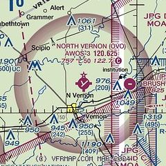
|
| Airport distance calculator |
|---|
|
|
| Sunrise and sunset |
|---|
|
Times for 31-May-2026
| | Local
(UTC-4) | | Zulu
(UTC) |
|---|
| Morning civil twilight | | 05:48 | | 09:48 |
| Sunrise | | 06:20 | | 10:20 |
| Sunset | | 21:00 | | 01:00 |
| Evening civil twilight | | 21:32 | | 01:32 |
|
| Current date and time |
|---|
| Zulu (UTC) | 31-May-2026 13:47:05 |
|---|
| Local (UTC-4) | 31-May-2026 09:47:05 |
|---|
|
| METAR |
|---|
KIMS
18nm S | 311335Z AUTO 07007KT 10SM CLR 18/10 A3009 RMK AO2
|
KBAK
19nm NW | 311245Z 09004KT 10SM CLR 15/10 A3008
|
KHLB
24nm NE | 311335Z AUTO VRB05KT 10SM CLR 16/10 A3009 RMK A01
|
KGEZ
34nm N | 311253Z AUTO 10009KT 10SM CLR 16/08 A3008 RMK AO2 SLP181 T01560083
|
|
| TAF |
|---|
KCVG
44nm E | 311120Z 3112/0118 08007KT P6SM BKN250 FM312200 VRB04KT P6SM SCT100 BKN200 FM011500 06008KT P6SM SCT100 BKN200
|
KBMG
47nm W | 311125Z 3112/0112 07007KT P6SM BKN250
|
|
| NOTAMs |
|---|
NOTAMs are issued by the DoD/FAA and will open in a separate window not controlled by AirNav.
|
|

