FAA INFORMATION EFFECTIVE 16 APRIL 2026
Location
| FAA Identifier: | GVT |
| Lat/Long: | 33-04-04.2000N 096-03-55.2000W
33-04.070000N 096-03.920000W
33.0678333,-96.0653333
(estimated) |
| Elevation: | 534.9 ft. / 163.0 m (surveyed) |
| Variation: | 05E (1995) |
| From city: | 4 miles SE of GREENVILLE, TX |
| Time zone: | UTC -5 (UTC -6 during Standard Time) |
| Zip code: | 75402 |
Airport Operations
| Airport use: | Open to the public |
| Activation date: | 07/1943 |
| Control tower: | yes |
| ARTCC: | FORT WORTH CENTER |
| FSS: | FORT WORTH FLIGHT SERVICE STATION |
| NOTAMs facility: | GVT (NOTAM-D service available) |
| Attendance: | FRI-SAT 0730-1800, ALL SUN-THU 0730-1700 |
| Wind indicator: | lighted |
| Segmented circle: | yes |
| Lights: | ACTVT MALS RWY 17; REIL RWY 35; MIRL RWY 17/35 - CTAF. |
| Beacon: | white-green (lighted land airport)
Operates sunset to sunrise. |
Airport Communications
| CTAF: | 118.65 |
| UNICOM: | 122.95 |
| WX AWOS-3: | 133.425 (903-455-7703) |
| MAJORS GROUND: | 121.7 335.8 [0730-1600 MON-FRI, IRREGULAR OTHER HOURS] |
| MAJORS TOWER: | 118.65 385.425 [0730-1600 MON-FRI, IRREGULAR OTHER HOURS] |
| AFMC: | 349.6 |
| EMERG: | 121.5 243.0 |
- APCH/DEP SVC PRVDD BY FORT WORTH ARTCC (ZFW) ON FREQS 132.025/317.75 (CUMBY RCAG).
- FREQ 349.6 SAME CONTROL 15048.
Nearby radio navigation aids
| VOR radial/distance | | VOR name | | Freq | | Var |
|---|
| BYPr157/29.4 | | BONHAM VORTAC | | 114.60 | | 06E |
Airport Services
| Fuel available: | 100LL JET-A
100LL:100LL SELF SVC AVBL 24 HRS. |
| Parking: | tiedowns |
| Airframe service: | MINOR |
| Powerplant service: | MINOR |
| Bottled oxygen: | NONE |
| Bulk oxygen: | NONE |
Runway Information
Runway 17/35
| Dimensions: | 8030 x 150 ft. / 2448 x 46 m |
| Surface: | asphalt, in good condition |
| Weight bearing capacity: | |
| Runway edge lights: | medium intensity |
| RUNWAY 17 | | RUNWAY 35 |
| Latitude: | 33-04.732520N | | 33-03.408510N |
| Longitude: | 096-03.909317W | | 096-03.929325W |
| Elevation: | 519.6 ft. | | 524.3 ft. |
| Traffic pattern: | left | | left |
| Runway heading: | 176 magnetic, 181 true | | 356 magnetic, 001 true |
| Markings: | precision, in good condition | | nonprecision, in good condition |
| Visual slope indicator: | 4-light PAPI on left (3.00 degrees glide path) | | 4-light PAPI on left (3.00 degrees glide path) |
| Approach lights: | MALS: 1,400 foot medium intensity approach lighting system | | |
| Runway end identifier lights: | | | yes |
| Touchdown point: | yes, no lights | | yes, no lights |
| Instrument approach: | ILS/DME | | |
| Obstructions: | 21 ft. ant, 354 ft. from runway, 265 ft. left of centerline, 7:1 slope to clear
10 FT RD. 0-145- DSTC | | 7 ft. fence, lighted, 201 ft. from runway, 450 ft. left of centerline |
Airport Ownership and Management from official FAA records
| Ownership: | Publicly-owned |
| Owner: | CITY OF GREENVILLE
2821 WASHINGTON STREET, P O BOX 1049
GREENVILLE, TX 75401
Phone 903-457-3116 |
| Manager: | TY HELTON
GREENVILLE MUNICIPAL AIRPORT, 101 MAJORS RD
GREENVILLE, TX 75401
Phone 903-457-3168
THELTON@CI.GREENVILLE.TX.US ALT PHONE 214-960-9294 |
Additional Remarks
| A95 | NMRS MIL ACFT ON FLD FOR MODIFICATION. |
| - | WHEN ATCT CLSD AND THERE IS AN EMERG OR INCIDENT ON ARPT, CTC 903-457-5333. |
| - | ACFT NOT VSB FM OPPOSITE END OF RWY. |
| - | MILITARY USE: JASU - 1(B-10) 1(B-10A) 1(MD-3) 1(MA-1) 1(MA-3). |
| - | 89 FT HIGH INTSTY RADIO FREQ ANT 3,700 FT EAST OF RWY 35 AT END OF TXY K. |
| - | TWY E LGTS 47 FT FM PAVEMENT EDGE. |
| - | PPR FOR PAJA ONTO MAJORS FLD. |
| - | WHEN ATCT CLSD, FOR CD CTC FORT WORTH ARTCC AT 817-858-7584. |
Instrument Procedures
NOTE: All procedures below are presented as PDF files. If you need a reader for these files, you should download the free Adobe Reader.NOT FOR NAVIGATION. Please procure official charts for flight.
FAA instrument procedures published for use from 16 April 2026 at 0901Z to 14 May 2026 at 0900Z.
IAPs - Instrument Approach Procedures |
|---|
| ILS Y OR LOC Y RWY 17 **CHANGED** | |
download (254KB) |
| ILS Z OR LOC Z RWY 17 | |
download (251KB) |
| RNAV (GPS) RWY 17 | |
download (239KB) |
| RNAV (GPS) RWY 35 | |
download (236KB) |
| VOR/DME RWY 17 | |
download (251KB) |
| TACAN RWY 17 | |
download (205KB) |
| TACAN RWY 35 | |
download (226KB) |
| NOTE: Special Alternate Minimums apply | |
download (139KB) |
| NOTE: Special Take-Off Minimums/Departure Procedures apply | |
download (113KB) |
Other nearby airports with instrument procedures:
7F3 - Caddo Mills Municipal Airport (9 nm W)
2F7 - Commerce Municipal Airport (16 nm NE)
F46 - Ralph M Hall/Rockwall Municipal Airport (20 nm SW)
KSLR - Sulphur Springs Municipal Airport (23 nm E)
KTRL - Terrell Municipal Airport (24 nm SW)
|
|

Road maps at:
MapQuest
Bing
Google
| Aerial photo |
|---|
WARNING: Photo may not be current or correct
 Photo by Kurtis K. Samples, AMS
Photo taken 18-Apr-2012
from 7500' flying east looking south.
Photo by Kurtis K. Samples, AMS
Photo taken 18-Apr-2012
from 7500' flying east looking south.
Do you have a better or more recent aerial photo of Majors Airport that you would like to share? If so, please send us your photo.
|
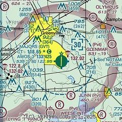
| Sectional chart |
|---|
|
| Airport distance calculator |
|---|
|
|
| Sunrise and sunset |
|---|
|
Times for 11-May-2026
| | Local
(UTC-5) | | Zulu
(UTC) |
|---|
| Morning civil twilight | | 06:02 | | 11:02 |
| Sunrise | | 06:29 | | 11:29 |
| Sunset | | 20:13 | | 01:13 |
| Evening civil twilight | | 20:40 | | 01:40 |
|
| Current date and time |
|---|
| Zulu (UTC) | 12-May-2026 03:07:04 |
|---|
| Local (UTC-5) | 11-May-2026 22:07:04 |
|---|
|
| METAR |
|---|
| KGVT | 120250Z AUTO 00000KT 10SM CLR 18/18 A3015 RMK AO2
|
|
| TAF |
|---|
KDAL
42nm W | 112058Z 1121/1218 04008KT P6SM BKN035 FM120200 VRB04KT P6SM SKC FM121500 17006KT P6SM SKC
|
KDFW
49nm W | 112058Z 1121/1224 04008KT P6SM BKN035 FM120200 VRB04KT P6SM SKC FM121500 17007KT P6SM SKC
|
|
| NOTAMs |
|---|
NOTAMs are issued by the DoD/FAA and will open in a separate window not controlled by AirNav.
|
|


