FAA INFORMATION EFFECTIVE 16 APRIL 2026
Location
| FAA Identifier: | IMS |
| Lat/Long: | 38-45-35.7000N 085-27-52.9000W
38-45.595000N 085-27.881667W
38.7599167,-85.4646944
(estimated) |
| Elevation: | 819.1 ft. / 249.7 m (surveyed) |
| Variation: | 03W (1995) |
| From city: | 4 miles W of MADISON, IN |
| Time zone: | UTC -4 (UTC -5 during Standard Time) |
| Zip code: | 47250 |
Airport Operations
| Airport use: | Open to the public |
| Activation date: | 05/1964 |
| Control tower: | no |
| ARTCC: | INDIANAPOLIS CENTER |
| FSS: | TERRE HAUTE FLIGHT SERVICE STATION |
| NOTAMs facility: | HUF (NOTAM-D service available) |
| Attendance: | MAR-OCT 0800-1800, NOV-FEB 0800-1700
UNATNDD THANKSGIVING, CHRISTMAS & NEW YEARS. |
| Wind indicator: | lighted |
| Segmented circle: | no |
| Lights: | ACTVT MALSF RWY 03; REIL RWY 21; PAPI RWY 03 & 21; HIRL RWY 03/21 - CTAF. |
| Beacon: | white-green (lighted land airport)
Operates sunset to sunrise. |
Airport Communications
| CTAF/UNICOM: | 123.0 |
| WX AWOS-3: | 119.175 (812-866-1798) |
| LOUISVILLE APPROACH: | 132.075 |
| LOUISVILLE DEPARTURE: | 132.075 |
| WX AWOS-3 at OVO (18 nm N): | 120.625 (812-346-5041) |
Nearby radio navigation aids
| VOR radial/distance | | VOR name | | Freq | | Var |
|---|
| IIUr007/39.7 | | LOUISVILLE VORTAC | | 114.80 | | 01E |
Airport Services
| Fuel available: | 100LL JET-A
100LL:SELF SERVE AVBL. |
| Parking: | hangars and tiedowns |
| Airframe service: | MAJOR |
| Powerplant service: | MAJOR |
Runway Information
Runway 3/21
| Dimensions: | 5000 x 75 ft. / 1524 x 23 m |
| Surface: | asphalt/grooved, in good condition |
| Weight bearing capacity: | | PCN 23 /F/C/X/T | | Single wheel: | 61.0 | | Double wheel: | 82.0 |
|
| Runway edge lights: | high intensity |
| RUNWAY 3 | | RUNWAY 21 |
| Latitude: | 38-45.244050N | | 38-45.944447N |
| Longitude: | 085-28.158653W | | 085-27.604917W |
| Elevation: | 807.2 ft. | | 819.1 ft. |
| Traffic pattern: | left | | left |
| Runway heading: | 035 magnetic, 032 true | | 215 magnetic, 212 true |
| Markings: | nonprecision, in good condition | | nonprecision, in good condition |
| Visual slope indicator: | 4-light PAPI on left (3.50 degrees glide path) | | 2-light PAPI on left (3.00 degrees glide path) |
| Approach lights: | MALSF: 1,400 foot medium intensity approach lighting system with sequenced flashers | | |
| Runway end identifier lights: | no | | yes |
| Touchdown point: | yes, no lights | | yes, no lights |
| Obstructions: | 80 ft. trees, lighted, 1850 ft. from runway, 435 ft. right of centerline, 20:1 slope to clear | | 10 ft. crops, 201 ft. from runway, 20:1 slope to clear |
Airport Ownership and Management from official FAA records
| Ownership: | Publicly-owned |
| Owner: | MADISON BOAC
101 W. MAIN ST.
MADISON, IN 47250
Phone 812-273-1914 |
| Manager: | BRENT SPRY
3919 W. IMS LANE
MADISON, IN 47250
Phone 812-273-1914 |
Additional Remarks
| - | FOR CD CTC LOUISVILLE APCH AT 502-375-7499 |
Instrument Procedures
NOTE: All procedures below are presented as PDF files. If you need a reader for these files, you should download the free Adobe Reader.NOT FOR NAVIGATION. Please procure official charts for flight.
FAA instrument procedures published for use from 16 April 2026 at 0901Z to 14 May 2026 at 0900Z.
IAPs - Instrument Approach Procedures |
|---|
| RNAV (GPS) RWY 21 | |
download (200KB) |
| RNAV (GPS) Y RWY 03 | |
download (191KB) |
| RNAV (GPS) Z RWY 03 | |
download (185KB) |
| NOTE: Special Alternate Minimums apply | |
download (150KB) |
| NOTE: Special Take-Off Minimums/Departure Procedures apply | |
download (493KB) |
Other nearby airports with instrument procedures:
KOVO - North Vernon Airport (18 nm N)
KSER - Freeman Municipal Airport (23 nm NW)
KJVY - Clark Regional Airport (27 nm SW)
KLOU - Bowman Field Airport (33 nm S)
I34 - Greensburg Municipal Airport (34 nm N)
|
|

Road maps at:
MapQuest
Bing
Google
| Aerial photo |
|---|
WARNING: Photo may not be current or correct
 Photo by Brent Spry
Photo taken 29-Oct-2018
looking south.
Photo by Brent Spry
Photo taken 29-Oct-2018
looking south.
Do you have a better or more recent aerial photo of Madison Regional Airport that you would like to share? If so, please send us your photo.
|
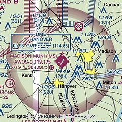
| Sectional chart |
|---|
|
| Airport distance calculator |
|---|
|
|
| Sunrise and sunset |
|---|
|
Times for 01-May-2026
| | Local
(UTC-4) | | Zulu
(UTC) |
|---|
| Morning civil twilight | | 06:17 | | 10:17 |
| Sunrise | | 06:45 | | 10:45 |
| Sunset | | 20:33 | | 00:33 |
| Evening civil twilight | | 21:01 | | 01:01 |
|
| Current date and time |
|---|
| Zulu (UTC) | 01-May-2026 10:56:06 |
|---|
| Local (UTC-4) | 01-May-2026 06:56:06 |
|---|
|
| METAR |
|---|
| KIMS | 011035Z AUTO 20005KT 10SM BKN070 OVC080 08/06 A2993 RMK AO2
|
|
| TAF |
|---|
KSDF
37nm S | 010520Z 0106/0212 01003KT P6SM SCT200 FM011200 23005KT P6SM OVC100 FM011600 30015G22KT P6SM BKN050 FM020000 34008KT P6SM SCT250
|
KCVG
41nm NE | 010854Z 0109/0212 18004KT P6SM BKN070 FM011200 23007KT P6SM BKN040 TEMPO 0113/0115 6SM -SHRA OVC035 FM011500 28011KT P6SM BKN030 FM011700 32013G20KT P6SM SCT050 FM020000 35007KT P6SM FEW035
|
|
| NOTAMs |
|---|
NOTAMs are issued by the DoD/FAA and will open in a separate window not controlled by AirNav.
|
|

