FAA INFORMATION EFFECTIVE 14 MAY 2026
Location
| FAA Identifier: | MSP |
| Lat/Long: | 44-52-55.1000N 093-13-18.4000W
44-52.918333N 093-13.306667W
44.8819722,-93.2217778
(estimated) |
| Elevation: | 841.8 ft. / 256.6 m (surveyed) |
| Variation: | 00E (2015) |
| From city: | 6 miles S of MINNEAPOLIS, MN |
| Time zone: | UTC -5 (UTC -6 during Standard Time) |
| Zip code: | 55450 |
Airport Operations
| Airport use: | Open to the public |
| Activation date: | 04/1940 |
| Control tower: | yes |
| ARTCC: | MINNEAPOLIS CENTER |
| FSS: | PRINCETON FLIGHT SERVICE STATION |
| NOTAMs facility: | MSP (NOTAM-D service available) |
| Attendance: | CONTINUOUS |
| Wind indicator: | lighted |
| Segmented circle: | no |
| Beacon: | white-green (lighted land airport)
Operates sunset to sunrise. |
| Landing fee: | yes |
| Fire and rescue: | ARFF index E |
| International operations: | customs landing rights airport |
Airport Communications
| UNICOM: | 122.95 |
| WX ASOS: | PHONE 218-203-0160 |
| MINNEAPOLIS GROUND: | 121.8 ;N 121.9 ;S 127.925 ;W 133.575 348.6 |
| MINNEAPOLIS TOWER: | 123.675 ;RWY 17/35 123.95 ;RWY 12L/30R 126.7 ;RWY 04/22, 12R/30L 273.55 |
| MINNEAPOLIS APPROACH: | 118.725 ;RWY 35 119.3 ;RWY 04/22, 12L/30R, 17 126.95 ;RWY 12R/30L |
| MINNEAPOLIS DEPARTURE: | 124.7 ;SOUTH OR EAST OF ARR RWY 125.75 ;NORTH OR WEST OF ARR RWY 132.975 ;E OF DEP RWY 17 |
| CLEARANCE DELIVERY: | 133.2 |
| PRE-TAXI CLEARANCE: | 133.2 |
| BAINY STAR: | 126.35 |
| BLUEM STAR: | 135.475 |
| CLASS B: | 121.2 ;NORTHEAST 126.5 ;NORTHWEST 134.7 ;SOUTH |
| COULT DP: | 124.7 ;SOUTH/EAST 125.75 ;NORTH/WEST |
| D-ATIS: | 120.8 ;DEP 135.35 ;ARR 239.275 ;ARR |
| EMERG: | 121.5 243.0 |
| GOPHER STAR: | 126.35 |
| HESTIN DP: | 124.7 ;SOUTH/EAST 125.75 ;NORTH/WEST |
| KASPR STAR: | 135.475 ;RWY 12L/30R, 12R/30L, 4/22, |
| KBREW DP: | 124.7 ;SOUTH/EAST 125.75 ;NORTH/WEST |
| KKILR STAR: | 126.35 |
| LEINY DP: | 124.7 ;SOUTH/EAST 125.75 ;NORTH/ WEST |
| MEADOW LAKE DP: | 124.7 ;SOUTH/EAST 125.75 ;NORTH/WEST |
| METERING: | 133.575 |
| MINNEAPOLIS DP: | 124.7 ;SOUTH/EAST 125.75 ;NORTH/WEST |
| MUSCL STAR: | 126.35 |
| NITZR STAR: | 135.475 |
| ORSKY DP: | 124.7 ;SOUTH/EAST 125.75 ;NORTH/WEST |
| PTD: | 282.675 324.1 |
| ROCHESTER DP: | 124.7 ;SOUTH/EAST 125.75 ;NORTH/WEST |
| SCHEP DP: | 124.7 ;SOUTH/EAST 125.75 ;NORTH/WEST |
| SLAYER DP: | 124.7 ;SOUTH/EAST 125.75 ;NORTH/WEST |
| SMERF DP: | 124.7 ;SOUTH/EAST 125.75 ;NORTH/WEST |
| TORGY STAR: | 135.475 |
| WLSTN DP: | 124.7 ;SOUTH/EAST 125.75 ;NORTH/WEST |
| ZMBRO DP: | 124.7 ;SOUTH/EAST 125.75 ;NORTH/WEST |
| WX ASOS at STP (8 nm NE): | 118.35 (651-312-8888) |
| WX AWOS-3 at SGS (8 nm E): | 119.425 (651-457-8120) |
| WX ASOS at FCM (11 nm W): | PHONE 952-941-4156 |
| WX ASOS at MIC (12 nm NW): | PHONE 763-531-2343 |
| WX AWOS-3 at LVN (15 nm S): | 118.0 (952-469-5850) |
| WX AWOS-3 at ANE (16 nm N): | PHONE 763-780-9025 |
| WX AWOS-3 at 21D (17 nm NE): | 120.075 (651-779-5949) |
- ASDE-X IN USE. OPERATE TRANSPONDERS WITH ALTITUDE REPORTING MODE AND ADS-B (IF EQUIPPED) ENABLED ON ALL AIRPORT SURFACES.
Nearby radio navigation aids
| VOR radial/distance | | VOR name | | Freq | | Var |
|---|
| MSPr142/1.1 | | MINNEAPOLIS VOR/DME | | 115.30 | | 02E |
| FCMr069/10.0 | | FLYING CLOUD VOR/DME | | 117.70 | | 01E |
| FGTr348/15.2 | | FARMINGTON VORTAC | | 115.70 | | 06E |
| GEPr152/17.1 | | GOPHER VORTAC | | 117.30 | | 06E |
Airport Services
| Fuel available: | 100LL JET-A JET-A++
100LL:FUEL CIV RAMP A+; NC-100LL - 612-726-5700.
A++:FUEL MIL RAMP - MILOPS. |
| Parking: | hangars and tiedowns |
| Airframe service: | MAJOR |
| Powerplant service: | MAJOR |
| Bottled oxygen: | HIGH |
| Bulk oxygen: | HIGH |
Runway Information
Runway 4/22
| Dimensions: | 11006 x 150 ft. / 3355 x 46 m |
| Surface: | concrete/grooved, in good condition |
| Weight bearing capacity: | | Single wheel: | 100.0 | | Double wheel: | 200.0 | | Double tandem: | 400.0 | | Dual double tandem: | 850.0 |
|
| Runway edge lights: | high intensity |
| RUNWAY 4 | | RUNWAY 22 |
| Latitude: | 44-52.335967N | | 44-53.616528N |
| Longitude: | 093-14.299045W | | 093-12.497390W |
| Elevation: | 833.5 ft. | | 830.3 ft. |
| Traffic pattern: | left | | left |
| Runway heading: | 045 | | 225 |
| Displaced threshold: | 1550 ft. | | 1000 ft. |
| Declared distances: | TORA:11006 TODA:11006 ASDA:11006 LDA:9456 | | TORA:11006 TODA:11006 ASDA:11006 LDA:10006 |
| Markings: | precision, in good condition | | precision, in good condition |
| Visual slope indicator: | 4-light PAPI on left (3.00 degrees glide path) | | 4-light PAPI on left (3.00 degrees glide path) |
| RVR equipment: | touchdown, rollout | | touchdown, rollout |
| Approach lights: | MALSR: 1,400 foot medium intensity approach lighting system with runway alignment indicator lights | | MALSR: 1,400 foot medium intensity approach lighting system with runway alignment indicator lights |
| Runway end identifier lights: | no | | no |
| Touchdown point: | yes, no lights | | yes, no lights |
| Instrument approach: | ILS | | LOCALIZER |
| Obstructions: | 101 ft. tree, 2906 ft. from runway, 834 ft. left of centerline, 26:1 slope to clear
APCH RATIO 43:1 TO DTHR OVR 102 FT TREE, 4456 FT DIST, 834 FT L. | | 66 ft. tree, 1350 ft. from runway, 636 ft. right of centerline, 17:1 slope to clear
8 FT FENCE, 500 FT R. |
Runway 12R/30L
| Dimensions: | 10000 x 200 ft. / 3048 x 61 m |
| Surface: | concrete/grooved, in good condition |
| Weight bearing capacity: | | Single wheel: | 100.0 | | Double wheel: | 200.0 | | Double tandem: | 400.0 | | Dual double tandem: | 850.0 |
|
| Runway edge lights: | high intensity |
| RUNWAY 12R | | RUNWAY 30L |
| Latitude: | 44-53.267397N | | 44-52.411333N |
| Longitude: | 093-14.047885W | | 093-12.071148W |
| Elevation: | 841.8 ft. | | 814.4 ft. |
| Traffic pattern: | left | | left |
| Runway heading: | 121 | | 301 |
| Declared distances: | TORA:10000 TODA:10000 ASDA:10000 LDA:10000 | | TORA:10000 TODA:10000 ASDA:10000 LDA:10000 |
| Markings: | precision, in good condition | | precision, in good condition |
| Visual slope indicator: | 4-light PAPI on left (3.00 degrees glide path) | | 4-light PAPI on left (3.00 degrees glide path) |
| RVR equipment: | touchdown, midfield, rollout | | touchdown, midfield, rollout |
| Approach lights: | ALSF2: standard 2,400 foot high intensity approach lighting system with centerline sequenced flashers (category II or III) | | ALSF2: standard 2,400 foot high intensity approach lighting system with centerline sequenced flashers (category II or III) |
| Runway end identifier lights: | no | | no |
| Centerline lights: | yes | | yes |
| Touchdown point: | yes, lighted | | yes, lighted |
| Instrument approach: | ILS/DME | | ILS/DME |
| Obstructions: | none | | 36 ft. tree, lighted, 1477 ft. from runway, 562 ft. right of centerline, 35:1 slope to clear |
Runway 12L/30R
| Dimensions: | 8200 x 150 ft. / 2499 x 46 m |
| Surface: | concrete/grooved, in fair condition |
| Weight bearing capacity: | | Single wheel: | 100.0 | | Double wheel: | 200.0 | | Double tandem: | 400.0 | | Dual double tandem: | 850.0 |
|
| Runway edge lights: | high intensity |
| RUNWAY 12L | | RUNWAY 30R |
| Latitude: | 44-53.577145N | | 44-52.875253N |
| Longitude: | 093-13.259443W | | 093-11.638267W |
| Elevation: | 838.6 ft. | | 819.5 ft. |
| Traffic pattern: | left | | left |
| Runway heading: | 121 | | 301 |
| Displaced threshold: | no | | 200 ft. |
| Declared distances: | TORA:8200 TODA:8200 ASDA:7620 LDA:7620 | | TORA:8200 TODA:8200 ASDA:8200 LDA:8000 |
| Markings: | precision, in good condition | | precision, in good condition |
| Visual slope indicator: | 4-light PAPI on left (3.00 degrees glide path) | | 4-light PAPI on left (3.00 degrees glide path) |
| RVR equipment: | touchdown, midfield, rollout | | touchdown, midfield, rollout |
| Approach lights: | ALSF2: standard 2,400 foot high intensity approach lighting system with centerline sequenced flashers (category II or III) | | MALSF: 1,400 foot medium intensity approach lighting system with sequenced flashers |
| Runway end identifier lights: | no | | no |
| Centerline lights: | yes | | yes |
| Touchdown point: | yes, lighted | | yes, no lights |
| Instrument approach: | ILS/DME | | ILS/DME |
| Obstructions: | 61 ft. tree, 3011 ft. from runway, 667 ft. right of centerline, 46:1 slope to clear | | 13 ft. tree, 808 ft. from runway, 272 ft. right of centerline, 46:1 slope to clear |
Runway 17/35
| Dimensions: | 8000 x 150 ft. / 2438 x 46 m |
| Surface: | concrete/grooved, in good condition |
| Weight bearing capacity: | | Single wheel: | 100.0 | | Double wheel: | 200.0 | | Double tandem: | 400.0 | | Dual double tandem: | 850.0 |
|
| Runway edge lights: | high intensity |
| RUNWAY 17 | | RUNWAY 35 |
| Latitude: | 44-53.265212N | | 44-51.970610N |
| Longitude: | 093-14.535228W | | 093-14.198675W |
| Elevation: | 840.4 ft. | | 833.3 ft. |
| Traffic pattern: | left | | left |
| Runway heading: | 170 | | 350 |
| Declared distances: | TORA:8000 TODA:8000 ASDA:8000 LDA:8000 | | TORA:8000 TODA:8000 ASDA:8000 LDA:8000 |
| Markings: | nonprecision, in good condition | | precision, in good condition |
| Visual slope indicator: | 4-light PAPI on right (3.00 degrees glide path) | | 4-light PAPI on left (3.00 degrees glide path) |
| RVR equipment: | touchdown, midfield, rollout | | touchdown, midfield, rollout |
| Approach lights: | | | ALSF2: standard 2,400 foot high intensity approach lighting system with centerline sequenced flashers (category II or III) |
| Runway end identifier lights: | yes | | no |
| Centerline lights: | yes | | yes |
| Touchdown point: | yes, no lights | | yes, lighted |
| Instrument approach: | LOC/DME | | ILS/DME |
| Obstructions: | 52 ft. tree, 1990 ft. from runway, 732 ft. right of centerline, 34:1 slope to clear | | none |
Airport Ownership and Management from official FAA records
| Ownership: | Publicly-owned |
| Owner: | METRO ARPT CMSN
6040 28TH AVE S
MINNEAPOLIS, MN 55450-2799
Phone 612-726-8100 |
| Manager: | BRIAN RYKS
6040 28TH AVE S
MINNEAPOLIS, MN 55450-2799
Phone 612-726-8100 |
Additional Remarks
| A39-12L/30R | PCR VALUE: 2160/R/D/W/T |
| A39-04/22 | PCR VALUE: 1350/R/D/W/T |
| A39-17/35 | PCR VALUE: 1840/R/D/W/T |
| A39-12R/30L | PCR VALUE: 2010/R/D/W/T |
| E60-12R | ENGINEERED MATERIALS ARRESTING SYSTEM (EMAS) 160 FT IN LENGTH BY 216 FT IN WIDTH LCTD AT DER 12R. |
| - | TRNG FLTS PROHIBITED. GA FLTS MUST TRMT AT THE FBO OR US CUSTOMS UNLESS APVD BY AMGR. |
| - | 133 AW AFLD MGMT - 324.1 REMARKS: CALL LIGHTHOUSE. |
| - | COMMUNICATIONS: MINNEAPOLIS AIR RESERVE STATION JOINT COMD POST - 252.1 REMARKS: CALL NORTHSTAR. |
| - | 934 AW AFLD MGMT - PTD 282.675 REMARKS: CALL VIKING OPS. |
| - | REMARKS: ALL ACFT MUST CTC NORTHSTAR ON FREQ 252.1 20 MIN PRIOR ARR. |
| - | UNSKED ACFT AT TRML 2-HUMPHREY REQ TO CTC TRML 2 GATE CONTROL ON 122.95 OR CALL 612-726-5742 PRIOR TO ARR. |
| - | NOISE ABATEMENT PROCEDURES - 612-726-9411. NO STAGE 1 CAT CIVIL ACFT. NIGHT HR 2230-0600. |
| - | ALL GROUP VI ACFT WITH WINGSPAN GREATER THAN 214 FT PPR REQ PRIOR TO ARR - CTC AIRSIDE OPS 612-726-5111. |
| - | RWY STATUS LGTS IN OPRN. |
| - | ALL GA ACFT WITH LESS THAN 20 PAX THAT NEED TO CLEAR US CUSTOMS SHOULD CTC SIGNATURE FLT SUPPORT 128.95 OR 612-726-5700 PRIOR TO ARR. |
| - | ALL GROUP IV AND LRGR ACFT OPRG ON THE PTN OF TWY S ADJ TO DELTA BLDG C RQR THE USE OF WINGWALKERS AND THAT THE VEHICLE SVC ROAD BE CLEAR OF VEHICLES. |
| - | AFRC - PPR ALL ACFT 72 HR PN RQR. |
| - | BIRDS ON & INVOF ARPT. |
| - | SIGNATURE FLIGHT SUPPORT 128.95 |
| - | MILITARY: ARFC 934 AW OPS 1300-0400Z++ MON-THUR, 1300-2200Z++ FRI, CLSD WKEND AND FEDERAL HOL. UNIT TRNG ASSEMBLY (UTA) WKEND 1330-2200Z++. ALL TRANS ACFT MUST RECEIVE PPR 72 HR PRIOR TO ETA - CTC AIRFIELD MGMT. |
| - | MILITARY RSTD: NO HAZ CL/DIV1.1 OR 1.2 EXPLOSIVES PERMITTED. LOADING OR UNLOADING OF HAZ CL/DIV 1.3, 1.4, 1.5 0R 1.6 MUST BE APV BY ARPT DRCT PRIOR TO FLT. |
Instrument Procedures
NOTE: All procedures below are presented as PDF files. If you need a reader for these files, you should download the free Adobe Reader.NOT FOR NAVIGATION. Please procure official charts for flight.
FAA instrument procedures published for use from 14 May 2026 at 0901Z to 11 June 2026 at 0900Z.
STARs - Standard Terminal Arrivals |
|---|
| BAINY FOUR (RNAV) | |
2 pages:
[1] [2] (458KB) |
| BLUEM FIVE (RNAV) | |
2 pages:
[1] [2] (520KB) |
| GOPHER ONE | |
download (248KB) |
| KASPR EIGHT | |
download (221KB) |
| KKILR FOUR (RNAV) | |
2 pages:
[1] [2] (460KB) |
| MUSCL FOUR (RNAV) | |
2 pages:
[1] [2] (492KB) |
| NITZR FOUR (RNAV) | |
2 pages:
[1] [2] (332KB) |
| NITZR FOUR (RNAV), CONT.2 | |
download (240KB) |
| TORGY FOUR (RNAV) | |
2 pages:
[1] [2] (446KB) |
IAPs - Instrument Approach Procedures |
|---|
| ILS OR LOC RWY 12L **CHANGED** | |
download (332KB) |
| ILS OR LOC RWY 12R | |
download (319KB) |
| ILS OR LOC RWY 30L | |
download (351KB) |
| ILS OR LOC RWY 30R | |
download (336KB) |
| ILS Z OR LOC RWY 35 | |
download (337KB) |
| ILS RWY 12L (SA CAT I) **CHANGED** | |
download (307KB) |
| ILS RWY 12R (SA CAT I) | |
download (301KB) |
| ILS RWY 35 (SA CAT I) | |
download (309KB) |
| ILS RWY 30L (CAT II) | |
download (333KB) |
| ILS RWY 12L (CAT II - III) **CHANGED** | |
download (316KB) |
| ILS RWY 12R (CAT II - III) | |
download (309KB) |
| ILS RWY 35 (CAT II - III) | |
download (304KB) |
| ILS V RWY 35 (CONVERGING) | |
download (309KB) |
| RNAV (RNP) Y RWY 12L | |
download (288KB) |
| RNAV (RNP) Y RWY 12R | |
download (290KB) |
| RNAV (RNP) Y RWY 30L | |
download (280KB) |
| RNAV (RNP) Y RWY 30R | |
download (299KB) |
| RNAV (RNP) Y RWY 35 | |
download (298KB) |
| RNAV (GPS) RWY 04 | |
download (286KB) |
| RNAV (GPS) RWY 22 | |
download (292KB) |
| RNAV (GPS) Z RWY 12L | |
download (292KB) |
| RNAV (GPS) Z RWY 12R | |
download (298KB) |
| RNAV (GPS) Z RWY 30L | |
download (312KB) |
| RNAV (GPS) Z RWY 30R | |
download (322KB) |
| RNAV (GPS) Z RWY 35 | |
download (290KB) |
| LOC RWY 04 | |
download (279KB) |
| LOC RWY 17 **CHANGED** | |
download (305KB) |
| LOC RWY 22 | |
download (304KB) |
| NOTE: Special Alternate Minimums apply **CHANGED** | |
download (176KB) |
Departure Procedures |
|---|
| COULT SEVEN | |
2 pages:
[1] [2] (463KB) |
| HESTIN SIX (RNAV) | |
download (208KB) |
| KBREW TWO | |
2 pages:
[1] [2] (361KB) |
| LEINY SIX (RNAV) | |
download (332KB) |
| MEADOW LAKE FIVE | |
download (185KB) |
| MINNEAPOLIS NINE | |
2 pages:
[1] [2] (361KB) |
| ORSKY THREE | |
2 pages:
[1] [2] (387KB) |
| ROCHESTER ONE | |
2 pages:
[1] [2] (489KB) |
| SCHEP ONE | |
2 pages:
[1] [2] (368KB) |
| SLAYER FOUR (RNAV) | |
download (201KB) |
| SMERF SEVEN (RNAV) | |
download (320KB) |
| WLSTN SEVEN | |
2 pages:
[1] [2] (435KB) |
| ZMBRO SEVEN | |
2 pages:
[1] [2] (470KB) |
| NOTE: Special Take-Off Minimums/Departure Procedures apply | |
download (156KB) |
Other nearby airports with instrument procedures:
KSTP - St Paul Downtown Airport Holman Field (8 nm NE)
KSGS - South St Paul Municipal Airport/Richard E Fleming Field (8 nm E)
KFCM - Flying Cloud Airport (11 nm W)
KMIC - Crystal Airport (12 nm NW)
KLVN - Airlake Airport (15 nm S)
KANE - Anoka County/Blaine Airport (Janes Field) (16 nm N)
21D - Lake Elmo Airport (17 nm NE)
|
|

Road maps at:
MapQuest
Bing
Google
| Aerial photo |
|---|
WARNING: Photo may not be current or correct
 Photo courtesy of AirNav, LLC
Photo taken 22-May-2017
looking northwest.
Photo courtesy of AirNav, LLC
Photo taken 22-May-2017
looking northwest.
Do you have a better or more recent aerial photo of Minneapolis-St Paul International/Wold-Chamberlain Airport that you would like to share? If so, please send us your photo.
|
| Sectional chart |
|---|
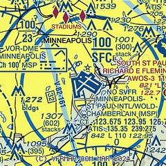
|
 Download PDF
of official airport diagram from the FAA
| Airport distance calculator |
|---|
|
|
| Sunrise and sunset |
|---|
|
Times for 16-May-2026
| | Local
(UTC-5) | | Zulu
(UTC) |
|---|
| Morning civil twilight | | 05:10 | | 10:10 |
| Sunrise | | 05:44 | | 10:44 |
| Sunset | | 20:35 | | 01:35 |
| Evening civil twilight | | 21:09 | | 02:09 |
|
| Current date and time |
|---|
| Zulu (UTC) | 16-May-2026 10:56:43 |
|---|
| Local (UTC-5) | 16-May-2026 05:56:43 |
|---|
|
| METAR |
|---|
| KMSP | 160953Z 00000KT 10SM CLR 16/04 A2976 RMK AO2 SLP073 T01560039
|
KSGS
4nm SE | 161035Z AUTO 00000KT 10SM CLR 13/04 A2978 RMK AO2 T01300042
|
KSTP
8nm NE | 160953Z AUTO 00000KT 10SM CLR 12/08 A2976 RMK AO2 SLP074 T01170078
|
KFCM
11nm W | 160953Z AUTO 30004KT 10SM CLR 14/04 A2976 RMK AO2 SLP072 T01390039
|
KMIC
12nm NW | 160953Z AUTO 30006KT 10SM CLR 13/02 A2975 RMK AO2 SLP070 T01330022
|
KANE
15nm N | 161035Z AUTO 00000KT 10SM CLR 14/02 A2977 RMK AO2
|
KLVN
16nm S | 161035Z AUTO 28005KT 10SM CLR 14/03 A2979 RMK AO2
|
K21D
17nm NE | 161035Z AUTO 00000KT 10SM CLR 08/05 A2979 RMK AO2
|
|
| TAF |
|---|
| KMSP | 160847Z 1609/1712 25004KT P6SM SKC FM161500 30010G18KT P6SM FEW250 FM170000 36008KT P6SM SCT200 FM170500 08012KT P6SM OVC200
|
|
| NOTAMs |
|---|
NOTAMs are issued by the DoD/FAA and will open in a separate window not controlled by AirNav.
|
|


