FAA INFORMATION EFFECTIVE 09 JULY 2026
Location
| FAA Identifier: | SLB |
| Lat/Long: | 42-35-50.0456N 095-14-26.3960W
42-35.834093N 095-14.439933W
42.5972349,-95.2406656
(estimated) |
| Elevation: | 1487.9 ft. / 453.5 m (surveyed) |
| Variation: | 04E (1995) |
| From city: | 3 miles SW of STORM LAKE, IA |
| Time zone: | UTC -5 (UTC -6 during Standard Time) |
| Zip code: | 50588 |
Airport Operations
| Airport use: | Open to the public |
| Activation date: | 01/1946 |
| Control tower: | no |
| ARTCC: | MINNEAPOLIS CENTER |
| FSS: | FORT DODGE FLIGHT SERVICE STATION |
| NOTAMs facility: | SLB (NOTAM-D service available) |
| Attendance: | JUNE - SEPT MON-SAT 0800-1700, OCT - MAY MON - SAT 0900 - 1700
FOR ATTANDANT AFTER HRS CALL 712-732-6301. |
| Wind indicator: | lighted |
| Segmented circle: | no |
| Lights: | ACTVT MIRL RWY 13/31 & RWY 17/35 & REIL RWY 17 & 35- CTAF. PAPI RWYS 17 & 35 OPER CONTINUOUSLY. |
| Beacon: | white-green (lighted land airport)
Operates sunset to sunrise. |
Airport Communications
| CTAF/UNICOM: | 122.7 |
| WX AWOS-3: | 118.525 (712-732-2301) |
| WX AWOS-3PT at CKP (16 nm NW): | 119.225 (712-225-1088) |
- APCH/DEP SVC PRVDD BY MINNEAPOLIS ARTCC ON FREQS 134.0/288.3 (FORT DODGE RCAG).
Nearby radio navigation aids
| VOR radial/distance | | VOR name | | Freq | | Var |
|---|
| SPWr178/33.9 | | SPENCER VOR/DME | | 115.15 | | 05E |
Airport Services
| Fuel available: | 100 JET-A |
| Parking: | hangars and tiedowns |
| Airframe service: | MAJOR |
| Powerplant service: | MAJOR |
| Bottled oxygen: | NONE |
| Bulk oxygen: | NONE |
Runway Information
Runway 17/35
| Dimensions: | 5002 x 75 ft. / 1525 x 23 m |
| Surface: | concrete, in good condition |
| Weight bearing capacity: | | Single wheel: | 30.0 | | Double wheel: | 38.0 |
|
| Runway edge lights: | medium intensity |
| RUNWAY 17 | | RUNWAY 35 |
| Latitude: | 42-36.063802N | | 42-35.243682N |
| Longitude: | 095-14.531545W | | 095-14.432698W |
| Elevation: | 1479.6 ft. | | 1479.8 ft. |
| Traffic pattern: | left | | left |
| Runway heading: | 171 magnetic, 175 true | | 351 magnetic, 355 true |
| Markings: | nonprecision, in good condition | | nonprecision, in good condition |
| Visual slope indicator: | 2-light PAPI on left (3.00 degrees glide path) | | 2-light PAPI on left (3.00 degrees glide path) |
| Runway end identifier lights: | yes | | yes |
| Touchdown point: | yes, no lights | | yes, no lights |
Runway 13/31
| Dimensions: | 3034 x 50 ft. / 925 x 15 m |
| Surface: | concrete, in good condition |
| Weight bearing capacity: | |
| Runway edge lights: | medium intensity |
| RUNWAY 13 | | RUNWAY 31 |
| Latitude: | 42-36.211667N | | 42-35.864120N |
| Longitude: | 095-14.622703W | | 095-14.137082W |
| Elevation: | 1477.4 ft. | | 1466.7 ft. |
| Traffic pattern: | left | | left |
| Runway heading: | 130 magnetic, 134 true | | 310 magnetic, 314 true |
| Displaced threshold: | 165 ft. | | no |
| Markings: | basic, in good condition | | basic, in good condition |
| Touchdown point: | yes, no lights | | yes, no lights |
| Obstructions: | 24 ft. road, 460 ft. from runway, 10:1 slope to clear
APCH RATIO FM DSPLCD THR 26:1. | | none |
Runway 6/24
| Dimensions: | 1962 x 95 ft. / 598 x 29 m |
| Surface: | turf, in good condition
CLSD WINTER MONTHS NOV THRU MAR. |
| Runway edge markings: | 06/24 MARKED WITH YELLOW CONES. |
| RUNWAY 6 | | RUNWAY 24 |
| Latitude: | 42-35.911862N | | 42-36.045613N |
| Longitude: | 095-14.624197W | | 095-14.226273W |
| Elevation: | 1487.9 ft. | | 1469.9 ft. |
| Traffic pattern: | left | | left |
| Runway heading: | 062 magnetic, 066 true | | 242 magnetic, 246 true |
| Touchdown point: | yes, no lights | | yes, no lights |
Airport Ownership and Management from official FAA records
| Ownership: | Publicly-owned |
| Owner: | CITY OF STORM LAKE
CITY HALL P.O. BOX 1086
STORM LAKE, IA 50588
Phone 712-732-8001 |
| Manager: | JIM BARTHOLOMEW
850 630TH ST
STORM LAKE, IA 50588
Phone 712-732-6494
EVENING PHONE 712-732-6301 |
Additional Remarks
| - | RY 35 IS CALM WIND RY. |
| - | FOR CD CTC MINNEAPOLIS ARTCC AT 651-463-5588. |
Instrument Procedures
NOTE: All procedures below are presented as PDF files. If you need a reader for these files, you should download the free Adobe Reader.NOT FOR NAVIGATION. Please procure official charts for flight.
FAA instrument procedures published for use from 09 July 2026 at 0901Z to 06 August 2026 at 0900Z.
IAPs - Instrument Approach Procedures |
|---|
| RNAV (GPS) RWY 17 | |
download (188KB) |
| RNAV (GPS) RWY 35 | |
download (207KB) |
| NOTE: Special Alternate Minimums apply | |
download (146KB) |
| NOTE: Special Take-Off Minimums/Departure Procedures apply | |
download (347KB) |
Other nearby airports with instrument procedures:
KCKP - Cherokee County Regional Airport (16 nm NW)
KSKI - Sac City Municipal Airport (17 nm SE)
KPOH - Pocahontas Municipal Airport (28 nm E)
KSPW - Spencer Municipal Airport (34 nm N)
KMEY - James G Whiting Memorial Field Airport (35 nm SW)
|
|

Road maps at:
MapQuest
Bing
Google
| Aerial photo |
|---|
WARNING: Photo may not be current or correct
 Photo by Michael Holm
Photo taken 18-Jun-2013
looking west.
Photo by Michael Holm
Photo taken 18-Jun-2013
looking west.
Do you have a better or more recent aerial photo of Storm Lake Municipal Airport that you would like to share? If so, please send us your photo.
|
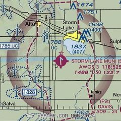
| Sectional chart |
|---|
|
| Airport distance calculator |
|---|
|
|
| Sunrise and sunset |
|---|
|
Times for 02-Aug-2026
| | Local
(UTC-5) | | Zulu
(UTC) |
|---|
| Morning civil twilight | | 05:43 | | 10:43 |
| Sunrise | | 06:15 | | 11:15 |
| Sunset | | 20:39 | | 01:39 |
| Evening civil twilight | | 21:11 | | 02:11 |
|
| Current date and time |
|---|
| Zulu (UTC) | 02-Aug-2026 21:32:36 |
|---|
| Local (UTC-5) | 02-Aug-2026 16:32:36 |
|---|
|
| METAR |
|---|
KCKP
16nm NW | 022115Z AUTO 14006KT 110V170 10SM CLR 29/17 A2993 RMK AO2
|
|
| TAF |
|---|
KFOD
48nm E | 021739Z 0218/0318 VRB03KT P6SM FEW250 FM030300 13003KT P6SM FEW250 FM031400 17008KT P6SM FEW020
|
|
| NOTAMs |
|---|
NOTAMs are issued by the DoD/FAA and will open in a separate window not controlled by AirNav.
|
|

