FAA INFORMATION EFFECTIVE 27 NOVEMBER 2025
Location
| FAA Identifier: | LCI |
| Lat/Long: | 43-34-22.9500N 071-25-04.2300W
43-34.382500N 071-25.070500W
43.5730417,-71.4178417
(estimated) |
| Elevation: | 545.4 ft. / 166.2 m (surveyed) |
| Variation: | 16W (1995) |
| From city: | 3 miles NE of LACONIA, NH |
| Time zone: | UTC -5 (UTC -4 during Daylight Saving Time) |
| Zip code: | 03246 |
Airport Operations
| Airport use: | Open to the public |
| Activation date: | 10/1946 |
| Control tower: | no |
| ARTCC: | BOSTON CENTER |
| FSS: | BANGOR FLIGHT SERVICE STATION |
| NOTAMs facility: | LCI (NOTAM-D service available) |
| Attendance: | MAY-OCT 0700-1900, NOV-APR 0800-1800 |
| Wind indicator: | lighted |
| Segmented circle: | yes |
| Lights: | DUSK-DAWN. ACTVT MALSR RWY 08; REIL RWY 26; HIRL RWY 08/26; WINDSOCK LGTS - CTAF. |
| Beacon: | white-green (lighted land airport)
Operates sunset to sunrise. |
Airport Communications
| CTAF/UNICOM: | 123.0 |
| WX AWOS-3PT: | 133.525 (603-524-5134) |
| BOSTON APPROACH: | 134.75 |
| BOSTON DEPARTURE: | 134.75 |
| CLEARANCE DELIVERY: | 119.85 |
| WX AWOS-3 at 1P1 (19 nm NW): | 118.45 (603-536-1698) |
Nearby radio navigation aids
| VOR radial/distance | | VOR name | | Freq | | Var |
|---|
| CONr033/22.3 | | CONCORD VOR/DME | | 112.90 | | 15W |
| ENEr301/36.1 | | KENNEBUNK VOR/DME | | 117.10 | | 17W |
| NDB name | | Hdg/Dist | | Freq | | Var | | ID |
|---|
| ROLLINS | | 325/33.3 | | 260 | | 16W | | ESG | . ... --. |
| HANOVER | | 118/33.9 | | 276 | | 15W | | LAH | .-.. .- .... |
Airport Services
| Fuel available: | 100LL JET-A JET-A+
A:FOR JET A AFT HRS CALL FBOS.
100LL:100LL AVBL 24 HRS WITH CREDIT CARD. |
| Parking: | hangars and tiedowns |
| Airframe service: | MAJOR |
| Powerplant service: | MAJOR |
| Bottled oxygen: | HIGH/LOW |
| Bulk oxygen: | HIGH/LOW |
Runway Information
Runway 8/26
| Dimensions: | 5890 x 100 ft. / 1795 x 30 m |
| Surface: | asphalt/grooved, in good condition |
| Weight bearing capacity: | | PCN 35 /F/D/X/T | | Single wheel: | 85.0 | | Double wheel: | 110.0 | | Double tandem: | 175.0 |
|
| Runway edge lights: | high intensity |
| RUNWAY 8 | | RUNWAY 26 |
| Latitude: | 43-34.197333N | | 43-34.567667N |
| Longitude: | 071-25.686667W | | 071-24.454333W |
| Elevation: | 545.4 ft. | | 515.5 ft. |
| Traffic pattern: | left | | left |
| Runway heading: | 084 magnetic, 068 true | | 264 magnetic, 248 true |
| Displaced threshold: | no | | 244 ft. |
| Declared distances: | TORA:5890 TODA:5890 ASDA:5646 LDA:5646 | | TORA:5890 TODA:5890 ASDA:5530 LDA:5286 |
| Markings: | precision, in fair condition | | nonprecision, in fair condition |
| Visual slope indicator: | 4-light PAPI on left (3.00 degrees glide path) | | 4-light PAPI on right (4.00 degrees glide path)
PAPI UNUSBL BYD 6 DEGS L OF CNTRLN. |
| Approach lights: | MALSR: 1,400 foot medium intensity approach lighting system with runway alignment indicator lights | | |
| Runway end identifier lights: | | | yes |
| Touchdown point: | yes, no lights | | yes, no lights |
| Instrument approach: | ILS/DME | | |
| Obstructions: | 57 ft. trees, 380 ft. from runway, 380 ft. right of centerline, 3:1 slope to clear | | 63 ft. trees, 496 ft. from runway, 479 ft. right of centerline, 4:1 slope to clear |
Airport Ownership and Management from official FAA records
| Ownership: | Publicly-owned |
| Owner: | LACONIA AIRPORT AUTHORITY
65 AVIATION DR
GILFORD, NH 03429
Phone 603-524-5003 |
| Manager: | MARV EVERSON
65 AVIATION DR
GILFORD, NH 03429
Phone 603-524-5003 |
Additional Remarks
| - | WILDLIFE ON & INVOF ARPT. |
| - | TWY A CLSD TO ACFT WITH WINGSPANS GTR THAN 49 FT. |
| - | FOR CD CTC BOSTON APCH AT 603-594-5552. |
| - | CTN: LOCKE'S HILL 500 FT TRRN MKD WITH 2 RED BCNS, 1.2 NM E OF ARPT. |
| - | CTN: RISING TRRN 5000 FT S OF ARPT. |
| - | RWY 26 DSGND CALM WIND RWY. |
| - | VOLUNTARY NOISE ABATEMENT PROC: AVOID OVERFLYING VARNEY POINT 1 NM NE OF ARPT. SEE LACONIA ARPT WEBSITE FOR DTLS. |
Instrument Procedures
NOTE: All procedures below are presented as PDF files. If you need a reader for these files, you should download the free Adobe Reader.NOT FOR NAVIGATION. Please procure official charts for flight.
FAA instrument procedures published for use from 27 November 2025 at 0901Z to 25 December 2025 at 0900Z.
IAPs - Instrument Approach Procedures |
|---|
| ILS OR LOC RWY 08 **CHANGED** | |
download (337KB) |
| RNAV (GPS) RWY 08 | |
download (254KB) |
| RNAV (GPS) RWY 26 | |
download (239KB) |
| NOTE: Special Alternate Minimums apply | |
download (153KB) |
| NOTE: Special Take-Off Minimums/Departure Procedures apply | |
download (178KB) |
Other nearby airports with instrument procedures:
KCON - Concord Municipal Airport (23 nm S)
KDAW - Skyhaven Airport (27 nm SE)
KIZG - White Mountain Regional Airport (32 nm NE)
KSFM - Sanford Seacoast Regional Airport (33 nm E)
2B3 - Parlin Field Airport (35 nm W)
|
|

Road maps at:
MapQuest
Bing
Google
| Aerial photo |
|---|
WARNING: Photo may not be current or correct
 Photo by Timothy J. Quill
Photo taken 24-Jul-2019
looking east.
Photo by Timothy J. Quill
Photo taken 24-Jul-2019
looking east.
Do you have a better or more recent aerial photo of Laconia Municipal Airport that you would like to share? If so, please send us your photo.
|
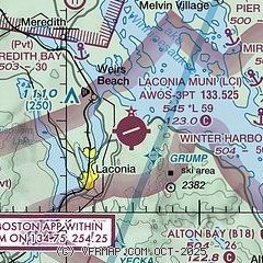
| Sectional chart |
|---|
|
CAUTION: Diagram may not be current

| Airport distance calculator |
|---|
|
|
| Sunrise and sunset |
|---|
|
Times for 08-Dec-2025
| | Local
(UTC-5) | | Zulu
(UTC) |
|---|
| Morning civil twilight | | 06:35 | | 11:35 |
| Sunrise | | 07:07 | | 12:07 |
| Sunset | | 16:08 | | 21:08 |
| Evening civil twilight | | 16:41 | | 21:41 |
|
| Current date and time |
|---|
| Zulu (UTC) | 09-Dec-2025 03:31:21 |
|---|
| Local (UTC-5) | 08-Dec-2025 22:31:21 |
|---|
|
| METAR |
|---|
| KLCI | 090256Z AUTO 00000KT 10SM CLR M17/M21 A3025 RMK AO2 SLP257 T11671206 58000 FZRANO
|
K1P1
19nm NW | 090315Z AUTO 00000KT 10SM CLR M21/M22 A3027 RMK AO2 T12061221
|
|
| TAF |
|---|
KCON
23nm S | 081720Z 0818/0918 32009KT P6SM FEW250
|
|
| NOTAMs |
|---|
NOTAMs are issued by the DoD/FAA and will open in a separate window not controlled by AirNav.
|
|


