FAA INFORMATION EFFECTIVE 15 MAY 2025
Location
| FAA Identifier: | LGD |
| Lat/Long: | 45-17-20.6810N 118-00-22.0460W
45-17.344683N 118-00.367433W
45.2890781,-118.0061239
(estimated) |
| Elevation: | 2717.6 ft. / 828.3 m (surveyed) |
| Variation: | 14E (2020) |
| From city: | 4 miles SE of LA GRANDE, OR |
| Time zone: | UTC -7 (UTC -8 during Standard Time) |
| Zip code: | 97850 |
Airport Operations
| Airport use: | Open to the public |
| Activation date: | 03/1940 |
| Control tower: | no |
| ARTCC: | SEATTLE CENTER |
| FSS: | MC MINNVILLE FLIGHT SERVICE STATION |
| NOTAMs facility: | LGD (NOTAM-D service available) |
| Attendance: | 0800-1700
CLOSED THANKSGIVING, CHRISTMAS AND NEW YEARS.
AFTER HOURS CALL OUT LIST POSTED ON DOOR. |
| Wind indicator: | lighted |
| Segmented circle: | yes
SEGMENTED CIRCLE MARKED IN WHITE ONLY |
| Lights: | ACTVT REIL RWY 17 & 35; PAPI RWY 17; MIRL RWY 12/30 & 17/35 - CTAF. |
| Beacon: | white-green (lighted land airport)
Operates sunset to sunrise. |
| Landing fee: | yes, OVER 12500 LBS. |
Airport Communications
| CTAF/UNICOM: | 122.8 |
| WX AWOS-3PT: | 135.075 (541-963-6824) |
- APCH/DEP CTL SVC PRVDD BY SEATTLE ARTCC (ZSE) ON FREQS 132.6/269.35 (WALLULA RCAG).
Nearby radio navigation aids
| VOR radial/distance | | VOR name | | Freq | | Var |
|---|
| BKEr323/28.2 | | BAKER CITY VOR/DME | | 115.30 | | 20E |
| NDB name | | Hdg/Dist | | Freq | | Var | | ID |
|---|
| LA GRANDE | | 196/3.7 | | 296 | | 14E | | LGD | .-.. --. -.. |
Airport Services
| Fuel available: | 100LL JET-A |
| Parking: | hangars and tiedowns |
| Airframe service: | MAJOR |
| Powerplant service: | MAJOR |
| Bottled oxygen: | NONE |
Runway Information
Runway 12/30
| Dimensions: | 6261 x 100 ft. / 1908 x 30 m |
| Surface: | asphalt, in good condition |
| Weight bearing capacity: | | Single wheel: | 65.0 | | Double wheel: | 90.0 | | Double tandem: | 130.0 |
|
| Runway edge lights: | medium intensity |
| RUNWAY 12 | | RUNWAY 30 |
| Latitude: | 45-17.732980N | | 45-17.004055N |
| Longitude: | 118-00.717887W | | 117-59.686550W |
| Elevation: | 2717.6 ft. | | 2706.8 ft. |
| Traffic pattern: | left | | left |
| Runway heading: | 121 magnetic, 135 true | | 301 magnetic, 315 true |
| Displaced threshold: | 760 ft. | | no |
| Declared distances: | TORA:6261 TODA:6261 | | TORA:6261 TODA:6261 |
| Markings: | nonprecision, in good condition | | nonprecision, in good condition |
| Visual slope indicator: | 2-light PAPI on left (3.00 degrees glide path)
PAPI RWY 12 DOES NOT PRVD OBSTN CLNC BYD 6.0 NM. | | 2-light PAPI on left (3.00 degrees glide path) |
| Runway end identifier lights: | | | yes |
| Touchdown point: | yes, no lights | | yes, no lights |
| Obstructions: | 15 ft. road, 335 ft. from runway, 9:1 slope to clear
RUNWAY 12 OBSTRUCTION CLEARANCE SLOPE 72:1 BASED ON DISPLACED THRESHOLD | | none |
Runway 17/35
| Dimensions: | 3400 x 75 ft. / 1036 x 23 m |
| Surface: | asphalt, in good condition |
| Weight bearing capacity: | | Single wheel: | 45.0 | | Double wheel: | 60.0 | | Double tandem: | 100.0 |
|
| Runway edge lights: | medium intensity |
| RUNWAY 17 | | RUNWAY 35 |
| Latitude: | 45-17.580400N | | 45-17.021073N |
| Longitude: | 118-00.671713W | | 118-00.671922W |
| Elevation: | 2713.8 ft. | | 2709.1 ft. |
| Traffic pattern: | left | | left |
| Runway heading: | 166 magnetic, 180 true | | 346 magnetic, 360 true |
| Markings: | nonprecision, in good condition | | nonprecision, in good condition |
| Visual slope indicator: | 4-light PAPI on left (3.00 degrees glide path) | | |
| Runway end identifier lights: | yes | | yes |
| Touchdown point: | yes, no lights | | yes, no lights |
Airport Ownership and Management from official FAA records
| Ownership: | Publicly-owned |
| Owner: | UNION COUNTY
1106 K AVENUE
LA GRANDE, OR 97850
Phone 514-963-1016 |
| Manager: | DOUG WRIGHT
60175 PIERCE ROAD
LA GRANDE, OR 97850
Phone 541-963-6615 |
Additional Remarks
| - | EXTSV FOREST SVC OPNS DURG SUMMER MOS. |
| - | FBO & FUELING LCTD WEST OF RWY 17/35 |
| - | COLD TEMPERATURE AIRPORT. ALTITUDE CORRECTION REQUIRED AT OR BELOW -17C. |
| - | FOR CD IF UNA TO CTC ON FSS FREQ, CTC SEATTLE ARTCC AT 253-351-3694. |
Instrument Procedures
NOTE: All procedures below are presented as PDF files. If you need a reader for these files, you should download the free Adobe Reader.NOT FOR NAVIGATION. Please procure official charts for flight.
FAA instrument procedures published for use from 15 May 2025 at 0901Z to 13 June 2025 at 0900z.
IAPs - Instrument Approach Procedures |
|---|
| RNAV (GPS) RWY 17 | |
download (517KB) |
| NDB-B | |
download (397KB) |
|
|---|
| LA GRANDE ONE (OBSTACLE) | |
download (304KB) |
| NOTE: Special Take-Off Minimums/Departure Procedures apply | |
download (525KB) |
Other nearby airports with instrument procedures:
KBKE - Baker City Municipal Airport (28 nm S)
KJSY - Joseph State Airport (32 nm E)
KPDT - Eastern Oregon Regional Airport at Pendleton (43 nm NW)
KALW - Walla Walla Regional Airport (50 nm N)
KHRI - Hermiston Municipal Airport (62 nm NW)
|
|

Road maps at:
MapQuest
Bing
Google
| Aerial photo |
|---|
WARNING: Photo may not be current or correct

Do you have a better or more recent aerial photo of La Grande/Union County Airport that you would like to share? If so, please send us your photo.
|
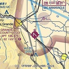
| Sectional chart |
|---|
|
| Airport distance calculator |
|---|
|
|
| Sunrise and sunset |
|---|
|
Times for 17-May-2025
| | Local
(UTC-7) | | Zulu
(UTC) |
|---|
| Morning civil twilight | | 04:46 | | 11:46 |
| Sunrise | | 05:21 | | 12:21 |
| Sunset | | 20:16 | | 03:16 |
| Evening civil twilight | | 20:51 | | 03:51 |
|
| Current date and time |
|---|
| Zulu (UTC) | 17-May-2025 13:22:27 |
|---|
| Local (UTC-7) | 17-May-2025 06:22:27 |
|---|
|
| METAR |
|---|
| KLGD | 171256Z AUTO 30004KT 10SM SCT100 06/06 A2983 RMK AO2 RAB38E53 SLP105 P0000 T00610056
|
|
| TAF |
|---|
KBKE
28nm S | 171120Z 1712/1812 VRB06KT 6SM -SHRA OVC050 FM171400 VRB04KT P6SM -SHRA FEW015 OVC050 PROB30 1714/1719 VRB10G25KT 5SM -TSRA OVC030CB FM171900 30012KT P6SM -SHRA OVC050 TEMPO 1719/1722 5SM -TSRA OVC030CB FM172200 33012G20KT P6SM -SHRA SCT020 OVC035 FM180500 33015G25KT P6SM OVC050
|
|
| NOTAMs |
|---|
NOTAMs are issued by the DoD/FAA and will open in a separate window not controlled by AirNav.
|
|


