FAA INFORMATION EFFECTIVE 14 MAY 2026
Location
| FAA Identifier: | LHZ |
| Lat/Long: | 36-01-24.0550N 078-19-48.9470W
36-01.400917N 078-19.815783W
36.0233486,-78.3302631
(estimated) |
| Elevation: | 368 ft. / 112.2 m (surveyed) |
| Variation: | 09W (2010) |
| From city: | 5 miles SW of LOUISBURG, NC |
| Time zone: | UTC -4 (UTC -5 during Standard Time) |
| Zip code: | 27549 |
Airport Operations
| Airport use: | Open to the public |
| Activation date: | 03/1993 |
| Control tower: | no |
| ARTCC: | WASHINGTON CENTER |
| FSS: | RALEIGH FLIGHT SERVICE STATION |
| NOTAMs facility: | LHZ (NOTAM-D service available) |
| Attendance: | 0800-1800
ARPT UNATNDD THANKSGIVING & CHRISTMAS. |
| Wind indicator: | lighted |
| Segmented circle: | yes |
| Lights: | ACTVT MALSR RWY 05; REIL RWY 23; HIRL RWY 05/23 - CTAF. PAPI RWY 05 & 23 OPER CONSLY. |
| Beacon: | white-green (lighted land airport)
Operates sunset to sunrise. |
Airport Communications
| CTAF/UNICOM: | 123.0 |
| WX AWOS-3: | 118.325 (919-497-0810) |
| RALEIGH APPROACH: | 125.3 |
| RALEIGH DEPARTURE: | 125.3 |
Nearby radio navigation aids
| VOR radial/distance | | VOR name | | Freq | | Var |
|---|
| RDUr077/23.8 | | RALEIGH/DURHAM VORTAC | | 117.20 | | 09W |
| TYIr280/30.5 | | TAR RIVER VORTAC | | 117.80 | | 05W |
| NDB name | | Hdg/Dist | | Freq | | Var | | ID |
|---|
| HUNTSBORO | | 149/21.7 | | 271 | | 09W | | HXO | .... -..- --- |
Airport Services
| Fuel available: | 100LL JET-A1+ |
| Parking: | tiedowns |
| Airframe service: | MAJOR |
| Powerplant service: | MAJOR |
| Bottled oxygen: | HIGH/LOW |
Runway Information
Runway 5/23
| Dimensions: | 5498 x 100 ft. / 1676 x 30 m |
| Surface: | asphalt/grooved, in excellent condition |
| Weight bearing capacity: | | Single wheel: | 63.0 | | Double wheel: | 91.0 |
|
| Runway edge lights: | high intensity |
| RUNWAY 5 | | RUNWAY 23 |
| Latitude: | 36-01.041347N | | 36-01.760480N |
| Longitude: | 078-20.155160W | | 078-19.476365W |
| Elevation: | 367.9 ft. | | 328.8 ft. |
| Traffic pattern: | right | | left |
| Runway heading: | 046 magnetic, 037 true | | 226 magnetic, 217 true |
| Markings: | precision, in good condition | | nonprecision, in good condition |
| Visual slope indicator: | 4-light PAPI on left (3.00 degrees glide path) | | 4-light PAPI on left (3.00 degrees glide path) |
| Approach lights: | MALSR: 1,400 foot medium intensity approach lighting system with runway alignment indicator lights | | |
| Runway end identifier lights: | no | | yes |
| Touchdown point: | yes, no lights | | yes, no lights |
| Instrument approach: | ILS/DME | | |
| Obstructions: | 41 ft. trees, 1640 ft. from runway, 352 ft. left of centerline, 35:1 slope to clear | | 41 ft. trees, 1537 ft. from runway, 502 ft. left of centerline, 32:1 slope to clear
2 FT RISING GND 157 FT FM THR BOTH SIDES OF CNTRLN. |
Airport Ownership and Management from official FAA records
| Ownership: | Publicly-owned |
| Owner: | FRANKLIN COUNTY
113 MARKET STREET
LOUISBURG, NC 27549
Phone 919-554-1863 |
| Manager: | BO CARSON
440 AIRPORT DRIVE
LOUISBURG, NC 27549
Phone 919-496-1234 |
Additional Remarks
| A39-05/23 | PCR VALUE: 240/F/C/X/T |
| - | ARPT PHONE 919-496-1234; MAKE PRIOR ARNGMTS DRG FBO HRS FOR SVCS AFT HRS. |
| - | BIRDS ON & INVOF ARPT. |
| - | HEL FLT TNG DLY PRIMRLY ON W SIDE OF ARPT AND TWY. |
| - | DLY SKYDIVING OPS. |
| - | GLIDER ACT DALGT HRS WKENDS. |
| - | FOR CD CTC RALEIGH APCH AT 919-380-3144. |
Instrument Procedures
NOTE: All procedures below are presented as PDF files. If you need a reader for these files, you should download the free Adobe Reader.NOT FOR NAVIGATION. Please procure official charts for flight.
FAA instrument procedures published for use from 14 May 2026 at 0901Z to 11 June 2026 at 0900Z.
IAPs - Instrument Approach Procedures |
|---|
| ILS OR LOC RWY 05 | |
download (322KB) |
| RNAV (GPS) RWY 05 | |
download (270KB) |
| RNAV (GPS) RWY 23 | |
download (265KB) |
| VOR-A | |
download (202KB) |
| NOTE: Special Alternate Minimums apply | |
download (145KB) |
| NOTE: Special Take-Off Minimums/Departure Procedures apply | |
download (357KB) |
Other nearby airports with instrument procedures:
KHNZ - Henderson/Oxford Airport (22 nm NW)
W03 - Wilson Industrial Air Center Airport (23 nm SE)
KRWI - Rocky Mount/Wilson Regional Airport (24 nm SE)
KRDU - Raleigh-Durham International Airport (24 nm W)
KJNX - Johnston Regional Airport (29 nm S)
|
|

Road maps at:
MapQuest
Bing
Google
| Aerial photo |
|---|
WARNING: Photo may not be current or correct

Do you have a better or more recent aerial photo of Triangle North Executive Airport that you would like to share? If so, please send us your photo.
|
| Sectional chart |
|---|
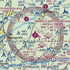
|
| Airport distance calculator |
|---|
|
|
| Sunrise and sunset |
|---|
|
Times for 28-May-2026
| | Local
(UTC-4) | | Zulu
(UTC) |
|---|
| Morning civil twilight | | 05:31 | | 09:31 |
| Sunrise | | 06:00 | | 10:00 |
| Sunset | | 20:21 | | 00:21 |
| Evening civil twilight | | 20:50 | | 00:50 |
|
| Current date and time |
|---|
| Zulu (UTC) | 28-May-2026 21:29:54 |
|---|
| Local (UTC-4) | 28-May-2026 17:29:54 |
|---|
|
| METAR |
|---|
| KLHZ | 282115Z AUTO 02005KT 10SM CLR 30/16 A2992 RMK AO2
|
|
| TAF |
|---|
KRWI
23nm SE | 281720Z 2818/2918 36009G17KT P6SM SCT060 SCT250 FM290000 04004KT P6SM BKN250
|
KRDU
24nm SW | 281720Z 2818/2918 36010G17KT P6SM SCT060 SCT250 FM290000 05004KT P6SM BKN250
|
|
| NOTAMs |
|---|
NOTAMs are issued by the DoD/FAA and will open in a separate window not controlled by AirNav.
|
|


