FAA INFORMATION EFFECTIVE 14 MAY 2026
Location
| FAA Identifier: | EIW |
| Lat/Long: | 36-32-07.1000N 089-35-59.0000W
36-32.118333N 089-35.983333W
36.5353056,-89.5997222
(estimated) |
| Elevation: | 295.8 ft. / 90.2 m (surveyed) |
| Variation: | 00E (2000) |
| From city: | 4 miles SW of NEW MADRID, MO |
| Time zone: | UTC -5 (UTC -6 during Standard Time) |
| Zip code: | 63866 |
Airport Operations
| Airport use: | Open to the public |
| Control tower: | no |
| ARTCC: | MEMPHIS CENTER |
| FSS: | SAINT LOUIS FLIGHT SERVICE STATION |
| NOTAMs facility: | STL (NOTAM-D service available) |
| Attendance: | OCT-MAR MON-FRI 0800-1630, APR-SEP MON-FRI 0800-1730, ALL SAT-SUN 0900-1630 |
| Wind indicator: | lighted |
| Segmented circle: | yes |
| Lights: | MIRL RWY 18/36 PRESET ON MED INTST; TO INCR INTST & ACTVT MIRL RWY 18/36 - CTAF. |
| Beacon: | white-green (lighted land airport)
Operates sunset to sunrise. |
Airport Communications
| CTAF/UNICOM: | 122.8 |
| WX AWOS-3PT at MAW (19 nm W): | 119.825 (573-276-9970) |
- UNICOM UNMON.
- APCH/DEP SVC PRVDD BY MEMPHIS ARTCC ON FREQS 133.65/292.15 (PADUCAH RCAG).
Airport Services
| Fuel available: | 100LL
100LL:FOR SVC AFT HRS, CALL ARPT MGR AT (573) 643-2403 OR (573) 934-3734. |
| Parking: | hangars and tiedowns |
| Powerplant service: | NONE |
Runway Information
Runway 18/36
| Dimensions: | 3200 x 60 ft. / 975 x 18 m |
| Surface: | asphalt, in good condition |
| Runway edge lights: | medium intensity |
| RUNWAY 18 | | RUNWAY 36 |
| Latitude: | 36-32.382167N | | 36-31.854833N |
| Longitude: | 089-35.984500W | | 089-35.982333W |
| Elevation: | 294.8 ft. | | 295.8 ft. |
| Traffic pattern: | left | | left |
| Runway heading: | 180 | | 360 |
| Markings: | nonprecision, in good condition | | nonprecision, in good condition |
| Touchdown point: | yes, no lights | | yes, no lights |
| Obstructions: | 15 ft. road, 300 ft. from runway, 250 ft. left and right of centerline, 6:1 slope to clear | | 22 ft. trees, 550 ft. from runway, 300 ft. left and right of centerline, 15:1 slope to clear |
Airport Ownership and Management from official FAA records
| Ownership: | Publicly-owned |
| Owner: | COUNTY OF NEW MADRID
450 MAIN STREET, PO BOX 68
NEW MADRID, MO 63869
Phone 573-748-2524 |
| Manager: | KEENAN CARLISLE
P.O. BOX 173
NEW MADRID, MO 63866
Phone 573-748-0302
COUNTY CLERK. |
Additional Remarks
| - | CROP DUSTING ACFT ON & INVOF ARPT. |
| - | WATERFOWL INVOF ARPT. |
| - | FOR CD CTC MEMPHIS ARTCC AT 901-368-8453/8449. |
Instrument Procedures
NOTE: All procedures below are presented as PDF files. If you need a reader for these files, you should download the free Adobe Reader.NOT FOR NAVIGATION. Please procure official charts for flight.
FAA instrument procedures published for use from 14 May 2026 at 0901Z to 11 June 2026 at 0900Z.
IAPs - Instrument Approach Procedures |
|---|
| RNAV (GPS) RWY 18 | |
download (209KB) |
| RNAV (GPS) RWY 36 | |
download (216KB) |
| NOTE: Special Take-Off Minimums/Departure Procedures apply | |
download (421KB) |
Other nearby airports with instrument procedures:
M85 - Gideon Memorial Airport (16 nm W)
KMAW - Malden Regional Airport (19 nm W)
KCHQ - Mississippi County Airport (22 nm NE)
KDXE - Dexter Municipal Airport (22 nm NW)
KSIK - Sikeston Memorial Municipal Airport (22 nm N)
|
|

Road maps at:
MapQuest
Bing
Google
| Aerial photo |
|---|
WARNING: Photo may not be current or correct

Do you have a better or more recent aerial photo of County Memorial Airport that you would like to share? If so, please send us your photo.
|
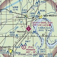
| Sectional chart |
|---|
|
| Airport distance calculator |
|---|
|
|
| Sunrise and sunset |
|---|
|
Times for 06-Jun-2026
| | Local
(UTC-5) | | Zulu
(UTC) |
|---|
| Morning civil twilight | | 05:11 | | 10:11 |
| Sunrise | | 05:41 | | 10:41 |
| Sunset | | 20:13 | | 01:13 |
| Evening civil twilight | | 20:43 | | 01:43 |
|
| Current date and time |
|---|
| Zulu (UTC) | 07-Jun-2026 00:13:51 |
|---|
| Local (UTC-5) | 06-Jun-2026 19:13:51 |
|---|
|
| METAR |
|---|
KMAW
19nm W | 062355Z AUTO 00000KT 10SM CLR 30/18 A2992 RMK AO1 LTG DSNT SW
|
KSIK
22nm N | 062355Z AUTO 00000KT 8SM FEW065 SCT100 OVC210 26/24 A2991 RMK AO2 60000 T02620237 10300 20253 58014 $
|
KTKX
28nm SW | 062355Z AUTO 14008KT 10SM CLR 30/21 A2989 RMK AO2
|
KUCY
31nm E | 062355Z AUTO 00000KT 10SM CLR 28/24 A2991 RMK A01
|
KCIR
37nm NE | 062355Z AUTO 00000KT 10SM SCT090 27/22 A2993 RMK AO2 T02700221 10293 20265
|
KPOF
37nm W | 062353Z AUTO 18004KT 10SM CLR 28/20 A2990 RMK AO2 SLP120 T02830200 10294 20278 56017
|
KHKA
38nm S | 062353Z AUTO 15008KT 10SM CLR 29/21 A2990 RMK AO2 SLP122 T02890206 10306 20289 58016 PWINO $
|
|
| TAF |
|---|
KCGI
42nm N | 061720Z 0618/0718 22006KT P6SM BKN060 FM070100 00000KT P6SM SCT050 BKN130 FM071400 17006KT P6SM SCT040 BKN080
|
|
| NOTAMs |
|---|
NOTAMs are issued by the DoD/FAA and will open in a separate window not controlled by AirNav.
|
|

