FAA INFORMATION EFFECTIVE 19 MARCH 2026
Location
| FAA Identifier: | MKO |
| Lat/Long: | 35-39-27.9000N 095-21-41.9000W
35-39.465000N 095-21.698333W
35.6577500,-95.3616389
(estimated) |
| Elevation: | 611.5 ft. / 186.4 m (surveyed) |
| Variation: | 06E (1985) |
| From city: | 6 miles S of MUSKOGEE, OK |
| Time zone: | UTC -5 (UTC -6 during Standard Time) |
| Zip code: | 74403 |
Airport Operations
| Airport use: | Open to the public |
| Activation date: | 04/1943 |
| Control tower: | no |
| ARTCC: | FORT WORTH CENTER |
| FSS: | MC ALESTER FLIGHT SERVICE STATION |
| NOTAMs facility: | MKO (NOTAM-D service available) |
| Attendance: | MON-SAT 0800-1700 |
| Wind indicator: | lighted |
| Segmented circle: | yes |
| Lights: | ACTVT MALS RWY 31; REIL RWY 13; MIRL RWY 13/31 - CTAF. PAPI RWY 13/31 ON CONSLY. |
| Beacon: | white-green (lighted land airport)
Operates sunset to sunrise. |
Airport Communications
| CTAF/UNICOM: | 122.8 |
| WX ASOS: | 135.025 (918-683-6987) |
- APCH/DEP CTL SVC PRVDD BY FORT WORTH ARTCC (ZFW) ON FREQS 132.2/338.35 (MC ALESTER RCAG).
Nearby radio navigation aids
| VOR radial/distance | | VOR name | | Freq | | Var |
|---|
| OKMr087/24.7 | | OKMULGEE VOR/DME | | 114.90 | | 08E |
| TULr139/38.4 | | TULSA VORTAC | | 114.40 | | 08E |
| NDB name | | Hdg/Dist | | Freq | | Var | | ID |
|---|
| HENRYETTA | | 060/35.3 | | 267 | | 04E | | HET | .... . - |
Airport Services
| Fuel available: | 100LL JET-A+
100LL:100LL AVBL H24 SELF SVC. |
| Parking: | hangars and tiedowns |
| Airframe service: | MINOR |
| Powerplant service: | MINOR |
| Bottled oxygen: | NONE |
| Bulk oxygen: | NONE |
Runway Information
Runway 13/31
| Dimensions: | 7202 x 150 ft. / 2195 x 46 m |
| Surface: | asphalt, in good condition |
| Weight bearing capacity: | | Single wheel: | 59.0 | | Double wheel: | 78.0 | | Double tandem: | 131.0 |
|
| Runway edge lights: | medium intensity |
| RUNWAY 13 | | RUNWAY 31 |
| Latitude: | 35-39.654667N | | 35-38.815717N |
| Longitude: | 095-22.031180W | | 095-21.002378W |
| Elevation: | 606.8 ft. | | 581.0 ft. |
| Traffic pattern: | left | | left |
| Runway heading: | 129 magnetic, 135 true | | 309 magnetic, 315 true |
| Markings: | nonprecision, in good condition | | nonprecision, in good condition |
| Visual slope indicator: | 4-light PAPI on left (3.00 degrees glide path) | | 4-light PAPI on left (3.00 degrees glide path) |
| Approach lights: | | | MALS: 1,400 foot medium intensity approach lighting system |
| Runway end identifier lights: | yes | | |
| Touchdown point: | yes, no lights | | yes, no lights |
Runway 4/22
| Dimensions: | 4498 x 75 ft. / 1371 x 23 m |
| Surface: | asphalt, in good condition |
| RUNWAY 4 | | RUNWAY 22 |
| Latitude: | 35-39.425788N | | 35-39.950172N |
| Longitude: | 095-22.289908W | | 095-21.647693W |
| Elevation: | 610.7 ft. | | 596.3 ft. |
| Traffic pattern: | left | | left |
| Runway heading: | 039 magnetic, 045 true | | 219 magnetic, 225 true |
| Markings: | nonprecision, in good condition | | nonprecision, in good condition |
| Touchdown point: | yes, no lights | | yes, no lights |
| Obstructions: | 26 ft. trees, 831 ft. from runway, 207 ft. right of centerline, 24:1 slope to clear | | none |
Runway 18/36
| Dimensions: | 1904 x 60 ft. / 580 x 18 m |
| Surface: | asphalt, in fair condition |
| RUNWAY 18 | | RUNWAY 36 |
| Latitude: | 35-39.959120N | | 35-39.645358N |
| Longitude: | 095-21.747653W | | 095-21.747848W |
| Elevation: | 596.8 ft. | | 596.1 ft. |
| Traffic pattern: | left | | left |
| Runway heading: | 174 magnetic, 180 true | | 354 magnetic, 000 true |
| Markings: | basic, in fair condition | | basic, in fair condition |
| Touchdown point: | yes, no lights | | yes, no lights |
Airport Ownership and Management from official FAA records
| Ownership: | Publicly-owned |
| Owner: | CITY OF MUSKOGEE
MUNICIPAL BLDG, P.O. BOX 1927
MUSKOGEE, OK 74402
Phone (918) 684-6201 |
| Manager: | TYLER EVANS
1201 SABRE ST
MUSKOGEE, OK 74403
Phone 918-684-6234
AFTER HRS FUEL CALL 918-869-8410. |
Additional Remarks
| - | TWY B CLSD TO ACFT OVER 25,000 LBS. |
| - | OCNL COYOTES ON & INVOF RWY. |
| - | AIRPORT USED FOR OKLAHOMA NATIONAL GUARD ATC TRAINING EVENTS - IRREGULAR SCHEDULE. CONTACT ATCT ON 118.95 WHEN OPERATIONAL. |
| - | FOR CD IF UNA TO CTC ON FSS FREQ, CTC FORT WORTH ARTCC AT 817-858-7584. |
Instrument Procedures
NOTE: All procedures below are presented as PDF files. If you need a reader for these files, you should download the free Adobe Reader.NOT FOR NAVIGATION. Please procure official charts for flight.
FAA instrument procedures published for use from 19 March 2026 at 0901Z to 16 April 2026 at 0900Z.
IAPs - Instrument Approach Procedures |
|---|
| RNAV (GPS) RWY 04 | |
download (250KB) |
| RNAV (GPS) RWY 13 | |
download (307KB) |
| RNAV (GPS) RWY 22 | |
download (272KB) |
| RNAV (GPS) RWY 31 | |
download (310KB) |
| NOTE: Special Alternate Minimums apply | |
download (122KB) |
| NOTE: Special Take-Off Minimums/Departure Procedures apply | |
download (401KB) |
Other nearby airports with instrument procedures:
H68 - Hefner-Easley Airport (19 nm N)
KTQH - Tahlequah Municipal Airport (24 nm NE)
KGZL - Stigler Regional Airport (26 nm SE)
KOKM - Okmulgee Regional Airport/Paul and Betty Abbott Field (29 nm W)
KJSV - Sallisaw Municipal Airport (30 nm SE)
|
|

Road maps at:
MapQuest
Bing
Google
| Aerial photo |
|---|
WARNING: Photo may not be current or correct
 Photo taken 09-Sep-2011
looking east.
Photo taken 09-Sep-2011
looking east.
Do you have a better or more recent aerial photo of Muskogee-Davis Regional Airport that you would like to share? If so, please send us your photo.
|
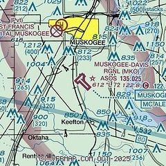
| Sectional chart |
|---|
|
| Airport distance calculator |
|---|
|
|
| Sunrise and sunset |
|---|
|
Times for 22-Mar-2026
| | Local
(UTC-5) | | Zulu
(UTC) |
|---|
| Morning civil twilight | | 06:58 | | 11:58 |
| Sunrise | | 07:23 | | 12:23 |
| Sunset | | 19:34 | | 00:34 |
| Evening civil twilight | | 19:59 | | 00:59 |
|
| Current date and time |
|---|
| Zulu (UTC) | 22-Mar-2026 13:41:45 |
|---|
| Local (UTC-5) | 22-Mar-2026 08:41:45 |
|---|
|
| METAR |
|---|
| KMKO | 221253Z AUTO 18009KT 10SM CLR 21/12 A2973 RMK AO2 SLP061 T02060122
|
|
| TAF |
|---|
KRVS
38nm NW | 221121Z 2212/2312 18008KT P6SM SCT250 WS020/22040KT FM221500 21014G23KT P6SM SCT250 FM222100 36018G28KT P6SM SCT080 SCT250 FM230300 02016G25KT P6SM BKN250
|
KTUL
41nm NW | 221121Z 2212/2312 17012KT P6SM SCT250 WS020/22040KT FM221500 21016G25KT P6SM SCT250 FM222100 35020G30KT P6SM SCT080 SCT250 FM230300 01016G25KT P6SM BKN250
|
|
| NOTAMs |
|---|
NOTAMs are issued by the DoD/FAA and will open in a separate window not controlled by AirNav.
|
|


