FAA INFORMATION EFFECTIVE 16 APRIL 2026
Location
| FAA Identifier: | TQH |
| Lat/Long: | 35-55-49.0000N 095-00-16.3000W
35-55.816667N 095-00.271667W
35.9302778,-95.0045278
(estimated) |
| Elevation: | 874.1 ft. / 266.4 m (surveyed) |
| Variation: | 05E (1995) |
| From city: | 2 miles NW of TAHLEQUAH, OK |
| Time zone: | UTC -5 (UTC -6 during Standard Time) |
| Zip code: | 74464 |
Airport Operations
| Airport use: | Open to the public |
| Activation date: | 10/1948 |
| Control tower: | no |
| ARTCC: | MEMPHIS CENTER |
| FSS: | MC ALESTER FLIGHT SERVICE STATION |
| NOTAMs facility: | TQH (NOTAM-D service available) |
| Attendance: | MON-FRI 0800-1700 |
| Wind indicator: | yes |
| Segmented circle: | yes |
| Lights: | ACTVT REIL RWY 17 & 35; MIRL RWY 17/35 - CTAF. PAPI RWY 17 & 35 ON CONSLY. |
| Beacon: | white-green (lighted land airport)
Operates sunset to sunrise. |
Airport Communications
| CTAF/UNICOM: | 122.8 |
| WX AWOS-3P: | 118.425 (918-453-2729) |
- APCH/DEP SVC PRVDD BY MEMPHIS ARTCC ON FREQS 126.1/269.0 (FAYETTEVILLE RCAG).
Nearby radio navigation aids
| NDB name | | Hdg/Dist | | Freq | | Var | | ID |
|---|
| SILOAM SPRINGS | | 234/29.5 | | 284 | | 04E | | SLG | ... .-.. --. |
Airport Services
| Fuel available: | 100LL JET-A+ |
| Parking: | hangars and tiedowns |
| Airframe service: | MAJOR |
| Powerplant service: | MAJOR |
Runway Information
Runway 17/35
| Dimensions: | 5001 x 75 ft. / 1524 x 23 m |
| Surface: | asphalt, in fair condition |
| Weight bearing capacity: | |
| Runway edge lights: | medium intensity |
| RUNWAY 17 | | RUNWAY 35 |
| Latitude: | 35-56.228988N | | 35-55.405447N |
| Longitude: | 095-00.251395W | | 095-00.290892W |
| Elevation: | 869.4 ft. | | 851.2 ft. |
| Traffic pattern: | left | | left |
| Runway heading: | 177 magnetic, 182 true | | 357 magnetic, 002 true |
| Markings: | nonprecision, in fair condition | | nonprecision, in fair condition |
| Visual slope indicator: | 4-light PAPI on left (3.50 degrees glide path) | | 4-light PAPI on left (3.00 degrees glide path)
PAPI UNUSBL BYD 8 DEGS RIGHT OF CNTRLN. |
| Runway end identifier lights: | yes | | yes |
| Touchdown point: | yes, no lights | | yes, no lights |
| Obstructions: | 68 ft. trees, 1280 ft. from runway, 343 ft. right of centerline, 15:1 slope to clear | | 31 ft. trees, 239 ft. from runway, 112 ft. left of centerline, 1:1 slope to clear
28 FT TREE 156 FT FM RWY END 131 FT L OF CNTRLN. |
Airport Ownership and Management from official FAA records
| Ownership: | Publicly-owned |
| Owner: | CITY OF TAHLEQUAH
CITY HALL, 111 S. CHEROKEE
TAHLEQUAH, OK 74464
Phone 918-456-0561 |
| Manager: | BRIAN LAMBERT
2100 AIRPORT PARKWAY
TAHLEQUAH, OK 74464
Phone (918) 708-5600 |
Additional Remarks
| - | FOR CD CTC MEMPHIS ARTCC AT 901-368-8453/8449. |
| - | SELF SVC CREDIT CARD FUEL H24. |
Instrument Procedures
NOTE: All procedures below are presented as PDF files. If you need a reader for these files, you should download the free Adobe Reader.NOT FOR NAVIGATION. Please procure official charts for flight.
FAA instrument procedures published for use from 16 April 2026 at 0901Z to 14 May 2026 at 0900Z.
IAPs - Instrument Approach Procedures |
|---|
| RNAV (GPS) RWY 17 | |
download (237KB) |
| RNAV (GPS) RWY 35 | |
download (236KB) |
| NOTE: Special Alternate Minimums apply | |
download (122KB) |
| NOTE: Special Take-Off Minimums/Departure Procedures apply | |
download (131KB) |
Other nearby airports with instrument procedures:
H68 - Hefner-Easley Airport (17 nm W)
H71 - Mid-America Industrial Airport (24 nm NW)
KMKO - Muskogee-Davis Regional Airport (24 nm SW)
KSLG - Smith Field Airport (29 nm NE)
KJSV - Sallisaw Municipal Airport (31 nm S)
|
|

Road maps at:
MapQuest
Bing
Google
| Aerial photo |
|---|
WARNING: Photo may not be current or correct
 Photo by Renee LaCombe
Photo taken 07-Nov-2013
looking north.
Photo by Renee LaCombe
Photo taken 07-Nov-2013
looking north.
Do you have a better or more recent aerial photo of Tahlequah Municipal Airport that you would like to share? If so, please send us your photo.
|
| Sectional chart |
|---|
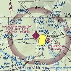
|
| Airport distance calculator |
|---|
|
|
| Sunrise and sunset |
|---|
|
Times for 01-May-2026
| | Local
(UTC-5) | | Zulu
(UTC) |
|---|
| Morning civil twilight | | 06:01 | | 11:01 |
| Sunrise | | 06:29 | | 11:29 |
| Sunset | | 20:06 | | 01:06 |
| Evening civil twilight | | 20:33 | | 01:33 |
|
| Current date and time |
|---|
| Zulu (UTC) | 02-May-2026 00:29:20 |
|---|
| Local (UTC-5) | 01-May-2026 19:29:20 |
|---|
|
| TAF |
|---|
KXNA
40nm NE | 011720Z 0118/0218 36008KT P6SM FEW060 BKN250 FM020200 00000KT P6SM BKN250 FM021500 31007KT P6SM FEW030 SCT070
|
KFYV
41nm E | 011720Z 0118/0218 35007KT P6SM FEW050 SCT100 BKN250 FM020200 00000KT P6SM FEW200 BKN250 FM021500 31007KT P6SM FEW030 SCT070
|
KTUL
46nm W | 011720Z 0118/0218 03008KT P6SM FEW060 SCT200 BKN250 FM020600 VRB03KT P6SM VCSH BKN070 OVC120 PROB30 0207/0212 6SM -SHRA BR FM021500 33004KT P6SM SCT060 SCT120
|
KFSM
47nm SE | 011720Z 0118/0218 05009KT P6SM FEW050 FEW150 BKN250 FM012100 36010KT P6SM FEW060 SCT200 BKN250 FM020300 VRB03KT P6SM BKN250 FM021500 30007KT P6SM FEW060 SCT100 SCT150
|
KRVS
48nm W | 011720Z 0118/0218 04008KT P6SM FEW060 SCT200 BKN250 FM020600 00000KT P6SM VCSH BKN070 OVC120 PROB30 0207/0212 6SM -SHRA BR FM021500 VRB04KT P6SM SCT060 SCT120
|
|
| NOTAMs |
|---|
NOTAMs are issued by the DoD/FAA and will open in a separate window not controlled by AirNav.
|
|

