FAA INFORMATION EFFECTIVE 19 MARCH 2026
Location
| FAA Identifier: | MMK |
| Lat/Long: | 41-30-31.3730N 072-49-46.1220W
41-30.522883N 072-49.768700W
41.5087147,-72.8294783
(estimated) |
| Elevation: | 103 ft. / 31.4 m (surveyed) |
| Variation: | 14W (1995) |
| From city: | 3 miles SW of MERIDEN, CT |
| Time zone: | UTC -4 (UTC -5 during Standard Time) |
| Zip code: | 06492 |
Airport Operations
| Airport use: | Open to the public |
| Activation date: | 04/1940 |
| Control tower: | no |
| ARTCC: | BOSTON CENTER |
| FSS: | BRIDGEPORT FLIGHT SERVICE STATION |
| NOTAMs facility: | MMK (NOTAM-D service available) |
| Attendance: | MON-SUN 0900-1700 |
| Wind indicator: | lighted |
| Segmented circle: | yes |
| Lights: | ACTVT REIL RWY 36; MIRL RWY 18/36 - CTAF. |
| Beacon: | white-green (lighted land airport)
Operates sunset to sunrise. |
Airport Communications
| CTAF/UNICOM: | 123.05 |
| WX ASOS: | 134.925 (203-639-9405) |
| BRADLEY APPROACH: | 127.8 |
| BRADLEY DEPARTURE: | 127.8 |
| CLEARANCE DELIVERY: | 120.65 |
| WX AWOS-3PT at 4B8 (11 nm N): | 119.175 (860-351-5362) |
| WX AWOS-AV at CT71 (12 nm N): | 129.825 |
| WX AWOS-3PT at OXC (14 nm W): | 132.975 (203-262-1190) |
| WX ASOS at HVN (15 nm S): | PHONE 203-466-6205 |
| WX ASOS at HFD (16 nm NE): | PHONE 860-952-9954 |
| WX AWOS-3 at SNC (16 nm SE): | 118.325 (860-526-1551) |
Nearby radio navigation aids
| VOR radial/distance | | VOR name | | Freq | | Var |
|---|
| MADr345/13.2 | | MADISON VOR/DME | | 110.40 | | 13W |
| HFDr251/14.9 | | HARTFORD VOR/DME | | 114.90 | | 13W |
| BDRr044/24.8 | | BRIDGEPORT VOR/DME | | 108.80 | | 12W |
| CCCr011/34.8 | | CALVERTON VOR/DME | | 114.55 | | 13W |
| CMKr080/36.5 | | CARMEL VOR/DME | | 116.60 | | 12W |
| GONr301/36.6 | | GROTON VOR/DME | | 110.85 | | 14W |
| ORWr280/37.4 | | NORWICH VOR/DME | | 110.00 | | 14W |
| PWLr126/38.0 | | PAWLING VOR/DME | | 114.30 | | 12W |
| BAFr201/39.5 | | BARNES VORTAC | | 113.00 | | 14W |
Airport Services
| Fuel available: | 100LL
100LL:SELF SVC FUEL. |
| Parking: | tiedowns |
| Airframe service: | MAJOR |
| Powerplant service: | MAJOR |
| Bottled oxygen: | NONE |
| Bulk oxygen: | NONE |
Runway Information
Runway 18/36
| Dimensions: | 3100 x 75 ft. / 945 x 23 m |
| Surface: | asphalt, in good condition |
| Weight bearing capacity: | |
| Runway edge lights: | medium intensity |
| RUNWAY 18 | | RUNWAY 36 |
| Latitude: | 41-30.765183N | | 41-30.280600N |
| Longitude: | 072-49.875433W | | 072-49.661983W |
| Elevation: | 103.0 ft. | | 98.6 ft. |
| Traffic pattern: | left | | left |
| Runway heading: | 176 magnetic, 162 true | | 356 magnetic, 342 true |
| Markings: | nonprecision, in good condition | | nonprecision, in good condition |
| Visual slope indicator: | | | 4-light PAPI on left (3.50 degrees glide path) |
| Runway end identifier lights: | | | yes |
| Touchdown point: | yes, no lights | | yes, no lights |
| Obstructions: | 60 ft. tree, 700 ft. from runway, 250 ft. left of centerline, 8:1 slope to clear
5 FT BRUSH, 0 FT DSTC, 161 FT R, 8 FT BR, 190 FT DSTC. | | 75 ft. tree, marked and lighted, 975 ft. from runway, 305 ft. right of centerline, 10:1 slope to clear |
Airport Ownership and Management from official FAA records
| Ownership: | Publicly-owned |
| Owner: | CITY OF MERIDEN
CITY MANAGER, CITY HALL, 142 E MAIN ST
MERIDEN, CT 06450
Phone (203) 630-4115 |
| Manager: | CONSTANCE CASTILLO
213 EVANSVILLE AVENUE
MERIDEN, CT 06451
Phone 203-630-2878 |
Additional Remarks
| - | RWY 36 NO TGLS. |
| - | CRANES 150 FT AGL, 0.25 MI NW AER 18, LGTD. OPER INTMT DALGT HRS. |
| - | PPR FOR JET ACFT. |
| - | CALM WIND RWY 18. |
| - | STD LEFT TFC, BOTH RWYS. |
| - | FOR CD CTC BRADLEY APCH AT 860-386-3597. |
| - | CTN DEER, COYOTES & BIRDS ON & INVOF ARPT. |
Instrument Procedures
NOTE: All procedures below are presented as PDF files. If you need a reader for these files, you should download the free Adobe Reader.NOT FOR NAVIGATION. Please procure official charts for flight.
FAA instrument procedures published for use from 19 March 2026 at 0901Z to 16 April 2026 at 0900Z.
IAPs - Instrument Approach Procedures |
|---|
| RNAV (GPS) RWY 36 | |
download (190KB) |
| VOR RWY 36 | |
download (247KB) |
| NOTE: Special Alternate Minimums apply | |
download (81KB) |
| NOTE: Special Take-Off Minimums/Departure Procedures apply | |
download (178KB) |
Other nearby airports with instrument procedures:
4B8 - Robertson Field Airport (11 nm N)
KOXC - Waterbury-Oxford Airport (14 nm W)
KHVN - Tweed/New Haven Airport (15 nm S)
KHFD - Hartford-Brainard Airport (16 nm NE)
KSNC - Chester Airport (16 nm SE)
|
|

Road maps at:
MapQuest
Bing
Google
| Aerial photo |
|---|
WARNING: Photo may not be current or correct
 Photo courtesy of Stephen Taylor Photo
Photo taken 19-Aug-2012
looking southeast.
Photo courtesy of Stephen Taylor Photo
Photo taken 19-Aug-2012
looking southeast.
Do you have a better or more recent aerial photo of Meriden Markham Municipal Airport that you would like to share? If so, please send us your photo.
|
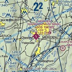
| Sectional chart |
|---|
|
| Airport distance calculator |
|---|
|
|
| Sunrise and sunset |
|---|
|
Times for 28-Mar-2026
| | Local
(UTC-4) | | Zulu
(UTC) |
|---|
| Morning civil twilight | | 06:14 | | 10:14 |
| Sunrise | | 06:42 | | 10:42 |
| Sunset | | 19:11 | | 23:11 |
| Evening civil twilight | | 19:39 | | 23:39 |
|
| Current date and time |
|---|
| Zulu (UTC) | 28-Mar-2026 23:01:01 |
|---|
| Local (UTC-4) | 28-Mar-2026 19:01:01 |
|---|
|
| METAR |
|---|
| KMMK | 282253Z AUTO VRB06KT 10SM CLR 03/M14 A3041 RMK AO2 SLP300 T00331139
|
KOXC
13nm W | 282156Z 28008G20KT 240V310 10SM FEW065 03/M13 A3038 RMK AO2 SLP310 T00281133 $
|
KHVN
15nm S | 282253Z 32010G17KT 300V360 10SM CLR 03/M13 A3042 RMK AO2 SLP300 T00331128 $
|
KHFD
16nm NE | 282253Z 30009G20KT 10SM FEW050 BKN070 02/M11 A3041 RMK AO2 SLP299 T00221111
|
KSNC
16nm SE | 282255Z AUTO VRB06KT 10SM SCT070 SCT080 03/M14 A3040 RMK AO2
|
|
| TAF |
|---|
KBDR
25nm SW | 281946Z 2820/2918 30012G19KT P6SM BKN080 FM282200 31010KT P6SM SCT070 FM290000 32005KT P6SM FEW150 FM290600 VRB03KT P6SM BKN150 FM291300 22007KT P6SM BKN150 FM291600 21013G20KT P6SM BKN150
|
KBDL
26nm N | 282031Z 2821/2924 32013G22KT P6SM BKN070 FM290000 30007KT P6SM FEW250 FM290500 24003KT P6SM SCT200 FM291600 22010G20KT P6SM FEW200
|
|
| NOTAMs |
|---|
NOTAMs are issued by the DoD/FAA and will open in a separate window not controlled by AirNav.
|
|

