FAA INFORMATION EFFECTIVE 22 JANUARY 2026
Location
| FAA Identifier: | MTW |
| Lat/Long: | 44-07-43.6000N 087-40-50.1000W
44-07.726667N 087-40.835000W
44.1287778,-87.6805833
(estimated) |
| Elevation: | 650.9 ft. / 198.4 m (surveyed) |
| Variation: | 02W (1985) |
| From city: | 2 miles NW of MANITOWOC, WI |
| Time zone: | UTC -6 (UTC -5 during Daylight Saving Time) |
| Zip code: | 54220 |
Airport Operations
| Airport use: | Open to the public |
| Activation date: | 10/1937 |
| Control tower: | no |
| ARTCC: | MINNEAPOLIS CENTER |
| FSS: | GREEN BAY FLIGHT SERVICE STATION |
| NOTAMs facility: | MTW (NOTAM-D service available) |
| Attendance: | MON-FRI 0700-1700, ALL SAT 0700-1300
AFT HRS CTC AMGR. |
| Wind indicator: | lighted |
| Segmented circle: | no |
| Lights: | HIRL RWY 17/35 PRESET TO LOW SS-SR; TO INCR INTST AND ACTVT MALSR RWY 17; REIL RWY 35; PAPI RWY 17 & 35; HIRL RWY 17/35; MIRL RWY 07/25 - CTAF. |
| Beacon: | white-green (lighted land airport)
Operates sunset to sunrise. |
Airport Communications
| CTAF/UNICOM: | 122.8 |
| WX AWOS-3PT: | 123.775 (920-682-1164) |
| GREEN BAY APPROACH: | 120.2 [0600-2300] |
| GREEN BAY DEPARTURE: | 120.2 [0600-2300] |
- APCH/DEP SVC PRVDD BY MINNEAPOLIS ARTCC ON 124.4/317.7 (MOSINEE RCAG) WHEN GREEN BAY APCH CLSD.
Nearby radio navigation aids
| VOR radial/distance | | VOR name | | Freq | | Var |
|---|
| GRBr138/33.8 | | GREEN BAY VORTAC | | 115.50 | | 01E |
| OSHr076/38.6 | | OSHKOSH VORTAC | | 116.75 | | 02E |
| NDB name | | Hdg/Dist | | Freq | | Var | | ID |
|---|
| MAWOC | | 170/4.4 | | 362 | | 02W | | MT | -- - |
Airport Services
| Fuel available: | 100LL JET-A+ MOGAS
100LL:24 HR SELF SVC FUEL AVBL WITH CREDIT CARD. |
| Parking: | hangars and tiedowns |
| Airframe service: | MINOR |
| Powerplant service: | MINOR |
| Bottled oxygen: | NONE |
| Bulk oxygen: | NONE |
Runway Information
Runway 17/35
| Dimensions: | 5001 x 100 ft. / 1524 x 30 m |
| Surface: | asphalt, in good condition |
| Weight bearing capacity: | | PCN 15 /F/D/X/T | | Single wheel: | 60.0 |
|
| Runway edge lights: | high intensity |
| RUNWAY 17 | | RUNWAY 35 |
| Latitude: | 44-08.051900N | | 44-07.241377N |
| Longitude: | 087-41.025920W | | 087-40.827112W |
| Elevation: | 646.2 ft. | | 650.0 ft. |
| Traffic pattern: | left | | left |
| Runway heading: | 172 magnetic, 170 true | | 352 magnetic, 350 true |
| Markings: | precision, in good condition | | precision, in good condition |
| Visual slope indicator: | 4-light PAPI on left (3.00 degrees glide path) | | 4-light PAPI on left (3.00 degrees glide path) |
| Approach lights: | MALSR: 1,400 foot medium intensity approach lighting system with runway alignment indicator lights | | |
| Runway end identifier lights: | | | yes |
| Touchdown point: | yes, no lights | | yes, no lights |
| Instrument approach: | ILS | | |
| Obstructions: | 20 ft. trees, 200 ft. from runway, 480 ft. left of centerline | | 66 ft. trees, 1400 ft. from runway, 575 ft. right of centerline, 18:1 slope to clear |
Runway 7/25
| Dimensions: | 3341 x 100 ft. / 1018 x 30 m |
| Surface: | asphalt, in good condition |
| Weight bearing capacity: | | PCN 6 /F/D/X/T | | Single wheel: | 12.0 |
|
| Runway edge lights: | medium intensity |
| RUNWAY 7 | | RUNWAY 25 |
| Latitude: | 44-07.751867N | | 44-07.937653N |
| Longitude: | 087-41.058603W | | 087-40.340033W |
| Elevation: | 650.9 ft. | | 638.3 ft. |
| Traffic pattern: | left | | left |
| Runway heading: | 072 magnetic, 070 true | | 252 magnetic, 250 true |
| Markings: | nonprecision, in good condition | | nonprecision, in good condition |
| Runway end identifier lights: | no | | no |
| Touchdown point: | yes, no lights | | yes, no lights |
Airport Ownership and Management from official FAA records
| Ownership: | Publicly-owned |
| Owner: | COUNTY OF MANITOWOC
1010 S 8TH
MANITOWOC, WI 54220
Phone 920-683-4594 |
| Manager: | BRYAN BARBEAU
1815 FREEDOM WAY
MANITOWOC, WI 54220
Phone 920-323-6522 |
Additional Remarks
| - | GEESE & NUMEROUS BIRDS ON & INVOF ARPT. |
Instrument Procedures
NOTE: All procedures below are presented as PDF files. If you need a reader for these files, you should download the free Adobe Reader.NOT FOR NAVIGATION. Please procure official charts for flight.
FAA instrument procedures published for use from 22 January 2026 at 0901Z to 19 February 2026 at 0900z.
IAPs - Instrument Approach Procedures |
|---|
| ILS OR LOC RWY 17 | |
download (232KB) |
| RNAV (GPS) RWY 17 | |
download (216KB) |
| RNAV (GPS) RWY 35 | |
download (216KB) |
| NOTE: Special Alternate Minimums apply | |
download (145KB) |
| NOTE: Special Take-Off Minimums/Departure Procedures apply | |
download (201KB) |
Other nearby airports with instrument procedures:
8D1 - New Holstein Municipal Airport (22 nm SW)
KSBM - Sheboygan County Memorial International Airport (23 nm S)
KGRB - Green Bay/Austin Straubel International Airport (29 nm NW)
KATW - Appleton International Airport (37 nm W)
KOSH - Wittman Regional Airport (39 nm W)
|
|

Road maps at:
MapQuest
Bing
Google
| Aerial photo |
|---|
WARNING: Photo may not be current or correct
 Photo by Nick Tognacci
Photo taken 24-May-2014
looking north.
Photo by Nick Tognacci
Photo taken 24-May-2014
looking north.
Do you have a better or more recent aerial photo of Manitowoc County Airport that you would like to share? If so, please send us your photo.
|
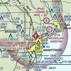
| Sectional chart |
|---|
|
| Airport distance calculator |
|---|
|
|
| Sunrise and sunset |
|---|
|
Times for 23-Jan-2026
| | Local
(UTC-6) | | Zulu
(UTC) |
|---|
| Morning civil twilight | | 06:47 | | 12:47 |
| Sunrise | | 07:18 | | 13:18 |
| Sunset | | 16:47 | | 22:47 |
| Evening civil twilight | | 17:19 | | 23:19 |
|
| Current date and time |
|---|
| Zulu (UTC) | 23-Jan-2026 18:08:12 |
|---|
| Local (UTC-6) | 23-Jan-2026 12:08:12 |
|---|
|
| METAR |
|---|
| KMTW | 231756Z AUTO 29013G21KT 10SM CLR M23/M31 A3066 RMK AO2 SLP404 T12281311 11228 21272 50015 FZRANO $
|
|
| TAF |
|---|
| KMTW | 231743Z 2318/2418 30011G19KT P6SM SKC FM240000 30011KT P6SM SKC FM240800 29007KT P6SM SCT250
|
|
| NOTAMs |
|---|
NOTAMs are issued by the DoD/FAA and will open in a separate window not controlled by AirNav.
|
|


