FAA INFORMATION EFFECTIVE 19 FEBRUARY 2026
Location
| FAA Identifier: | OUN |
| Lat/Long: | 35-14-44.0000N 097-28-19.7000W
35-14.733333N 097-28.328333W
35.2455556,-97.4721389
(estimated) |
| Elevation: | 1181.7 ft. / 360.2 m (surveyed) |
| Variation: | 03E (2020) |
| From city: | 3 miles NW of NORMAN, OK |
| Time zone: | UTC -6 (UTC -5 during Daylight Saving Time) |
| Zip code: | 73069 |
Airport Operations
| Airport use: | Open to the public |
| Activation date: | 01/1941 |
| Control tower: | yes |
| ARTCC: | FORT WORTH CENTER |
| FSS: | MC ALESTER FLIGHT SERVICE STATION |
| NOTAMs facility: | OUN (NOTAM-D service available) |
| Attendance: | 0600-2200 |
| Wind indicator: | lighted |
| Segmented circle: | yes |
| Lights: | WHEN ATCT CLSD ACTVT MIRL RYS 03/21 & 18/36; REIL RY 36;MALSR RY 18 & MALS RY 03 - CTAF. |
| Beacon: | white-green (lighted land airport)
Operates sunset to sunrise. |
| Landing fee: | yes, SPL EVENT FEE FOR ALL ACFT THE DAY BEFORE AND DAY OF A UNIVERSITY HOME FOOTBALL GAME. |
Airport Communications
| CTAF: | 118.0 |
| UNICOM: | 122.95 |
| WX AWOS-3PT: | 119.55 (405-325-7302) |
| WESTHEIMER GROUND: | 121.6 [0800-2200] |
| WESTHEIMER TOWER: | 118.0 [0800-2200] |
| OKE CITY APPROACH: | 120.45 |
| OKE CITY DEPARTURE: | 120.45 |
| BASTS RNAV STAR: | 124.6 |
| CCASH RNAV STAR: | 124.6 |
| DAWKS RNAV STAR: | 124.6 |
| FAKEY RNAV STAR: | 124.6 |
| JUDDG RNAV STAR: | 124.2 |
| KRMSN DP: | 120.45 ;SOUTH 133.6 ;NORTH |
| WAYMAN RNAV STAR: | 124.2 |
| WX ASOS at OKC (11 nm NW): | PHONE 405-674-4013 |
| WX ASOS at PWA (19 nm NW): | PHONE 405-798-2013 |
Nearby radio navigation aids
| VOR radial/distance | | VOR name | | Freq | | Var |
|---|
| IRWr128/9.5 | | WILL ROGERS VORTAC | | 114.10 | | 07E |
| PWAr146/19.3 | | WILEY POST VOR/DME | | 113.40 | | 08E |
Airport Services
| Fuel available: | 100LL JET-A+ |
| Parking: | hangars and tiedowns |
| Airframe service: | MAJOR |
| Powerplant service: | MAJOR |
| Bottled oxygen: | NONE |
| Bulk oxygen: | NONE |
Runway Information
Runway 18/36
| Dimensions: | 5199 x 100 ft. / 1585 x 30 m |
| Surface: | asphalt/grooved, in good condition |
| Weight bearing capacity: | | Single wheel: | 30.0 | | Double wheel: | 50.0 | | Double tandem: | 100.0 |
|
| Runway edge lights: | medium intensity |
| RUNWAY 18 | | RUNWAY 36 |
| Latitude: | 35-15.386387N | | 35-14.529492N |
| Longitude: | 097-28.386863W | | 097-28.380738W |
| Elevation: | 1181.6 ft. | | 1177.2 ft. |
| Traffic pattern: | right | | left |
| Runway heading: | 177 magnetic, 180 true | | 357 magnetic, 360 true |
| Markings: | precision, in good condition | | nonprecision, in good condition |
| Visual slope indicator: | 4-light PAPI on left (3.00 degrees glide path) | | 4-light PAPI on left (3.00 degrees glide path) |
| Approach lights: | MALSR: 1,400 foot medium intensity approach lighting system with runway alignment indicator lights | | |
| Runway end identifier lights: | | | yes |
| Touchdown point: | yes, no lights | | yes, no lights |
| Instrument approach: | ILS/DME | | |
Runway 3/21
| Dimensions: | 4748 x 100 ft. / 1447 x 30 m |
| Surface: | asphalt, in good condition |
| Weight bearing capacity: | | Single wheel: | 30.0 | | Double wheel: | 50.0 | | Double tandem: | 100.0 |
|
| Runway edge lights: | medium intensity |
| RUNWAY 3 | | RUNWAY 21 |
| Latitude: | 35-14.172888N | | 35-14.804358N |
| Longitude: | 097-28.547933W | | 097-27.984340W |
| Elevation: | 1175.2 ft. | | 1179.1 ft. |
| Traffic pattern: | left | | right |
| Runway heading: | 033 magnetic, 036 true | | 213 magnetic, 216 true |
| Markings: | nonprecision, in fair condition | | nonprecision, in fair condition |
| Visual slope indicator: | 4-light PAPI on left (3.00 degrees glide path) | | 4-light PAPI on left (3.00 degrees glide path) |
| Approach lights: | MALS: 1,400 foot medium intensity approach lighting system | | |
| Touchdown point: | yes, no lights | | yes, no lights |
| Instrument approach: | LOC/DME | | |
Airport Ownership and Management from official FAA records
| Ownership: | Publicly-owned |
| Owner: | UNIV OF OKLAHOMA
1700 LEXINGTON AVE
NORMAN, OK 73069
Phone 405-325-7233 |
| Manager: | LANCE LAMKIN
1700 LEXINGTON AVE, SUITE 212
NORMAN, OK 73069
Phone 405-325-7233 |
Additional Remarks
| - | 180 DEG TURNS PROHIBITED ON RWYS FOR ALL OTHER THAN SINGLE ENGINE LIGHT ACFT. |
| - | CTN: COYOTES & BIRDS ON & INVOF OF RWYS. |
| - | HIGH DENSITY STUDENT OPNS INVOF ARPT & 5 MILES SOUTH. |
| - | TPA FOR HELS 500 FT AGL; SINGLE ENGINE 1000 FT AGL; MULTI-ENGINE & JETS 1500 FT AGL. |
| - | FOR CD IFUN TO CTC TWR, CTC OKE CITY APCH AT 405-681-5683. |
| - | PPR RQRD ALL TSNT ACFT DAY BFR & DAY OF UNIVERSITY HOME FOOTBALL GAME AT 405-360-3900. |
| - | PILOTS CONDUCTING EFVS OPS; BE AWARE LED ALS IN USE RWY 03. |
Instrument Procedures
NOTE: All procedures below are presented as PDF files. If you need a reader for these files, you should download the free Adobe Reader.NOT FOR NAVIGATION. Please procure official charts for flight.
FAA instrument procedures published for use from 19 February 2026 at 0901Z to 19 March 2026 at 0900Z.
STARs - Standard Terminal Arrivals |
|---|
| BASTS ONE (RNAV) | |
download (175KB) |
| CCASH ONE (RNAV) | |
download (177KB) |
| DAWKS ONE (RNAV) | |
download (178KB) |
| FAKEY ONE (RNAV) | |
download (114KB) |
| GULLI THREE | |
2 pages:
[1] [2] (336KB) |
| JUDDG TWO (RNAV) | |
download (249KB) |
| WAYMN ONE (RNAV) | |
download (185KB) |
IAPs - Instrument Approach Procedures |
|---|
| ILS OR LOC RWY 18 | |
download (336KB) |
| RNAV (GPS) RWY 03 | |
download (317KB) |
| RNAV (GPS) RWY 18 | |
download (249KB) |
| RNAV (GPS) RWY 36 | |
download (267KB) |
| LOC RWY 03 | |
download (284KB) |
| NOTE: Special Alternate Minimums apply | |
download (39KB) |
Departure Procedures |
|---|
| FUNNL THREE (RNAV) | |
download (205KB) |
| KRMSN FOUR (RNAV) **CHANGED** | |
download (220KB) |
| MUDDE THREE (RNAV) | |
download (219KB) |
| OLGUY THREE (RNAV) | |
download (220KB) |
| RDHWK THREE (RNAV) | |
download (204KB) |
| SSYKO THREE (RNAV) | |
download (211KB) |
| STPHN THREE (RNAV) | |
download (210KB) |
| TEBRD THREE (RNAV) | |
download (207KB) |
| THRPE THREE (RNAV) | |
download (214KB) |
| TRUPR THREE (RNAV) | |
download (223KB) |
| WENDY THREE (RNAV) | |
download (222KB) |
| NOTE: Special Take-Off Minimums/Departure Procedures apply | |
download (186KB) |
Other nearby airports with instrument procedures:
1K4 - David Jay Perry Airport (5 nm S)
KOKC - OKC Will Rogers International Airport (11 nm NW)
KTIK - Tinker Air Force Base (11 nm N)
KHMY - Muldrow Army Heliport (18 nm SE)
KPWA - Wiley Post Airport (19 nm NW)
|
|

Road maps at:
MapQuest
Bing
Google
| Aerial photo |
|---|
WARNING: Photo may not be current or correct
 Photo by Matthew Hopson
Photo taken from 3400 ft AGL
Photo by Matthew Hopson
Photo taken from 3400 ft AGL
Do you have a better or more recent aerial photo of University of Oklahoma Westheimer Airport that you would like to share? If so, please send us your photo.
|
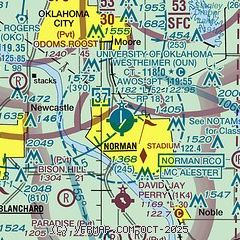
| Sectional chart |
|---|
|
 Download PDF
of official airport diagram from the FAA
| Airport distance calculator |
|---|
|
|
| Sunrise and sunset |
|---|
|
Times for 18-Mar-2026
| | Local
(UTC-5) | | Zulu
(UTC) |
|---|
| Morning civil twilight | | 07:12 | | 12:12 |
| Sunrise | | 07:37 | | 12:37 |
| Sunset | | 19:39 | | 00:39 |
| Evening civil twilight | | 20:04 | | 01:04 |
|
| Current date and time |
|---|
| Zulu (UTC) | 18-Mar-2026 18:06:49 |
|---|
| Local (UTC-5) | 18-Mar-2026 13:06:49 |
|---|
|
| METAR |
|---|
KOUN
2nm SE | 181745Z 19012KT 10SM CLR 22/M06 A3005
|
KOKC
10nm NW | 181752Z 24011KT 10SM SCT200 BKN250 22/M05 A3006 RMK AO2 SLP174 T02221050 10222 20089 50008
|
KTIK
11nm NE | 181755Z AUTO 22011KT 10SM CLR 22/M07 A3006 RMK AO2 SLP176 T02221066 10223 20094 51011
|
KPWA
19nm NW | 181753Z 20011KT 10SM CLR 21/M03 A3006 RMK AO2 SLP174 T02111033 10211 20100 51010
|
|
| TAF |
|---|
KOUN
2nm SE | 181720Z 1818/1918 21012KT P6SM BKN250 FM190200 17007KT P6SM SCT250
|
KOKC
10nm NW | 181720Z 1818/1918 23010KT P6SM BKN250 FM190200 17007KT P6SM SCT250
|
KTIK
11nm NE | 181700Z 1817/1923 23012G18KT 9999 FEW150 SCT200 QNH3005INS BECMG 1819/1820 20009KT 9999 SCT150 QNH3006INS TX23/1822Z TN11/1913Z
|
|
| NOTAMs |
|---|
NOTAMs are issued by the DoD/FAA and will open in a separate window not controlled by AirNav.
|
|


