FAA INFORMATION EFFECTIVE 15 MAY 2025
Location
| FAA Identifier: | OXB |
| Lat/Long: | 38-18-37.7250N 075-07-26.4910W
38-18.628750N 075-07.441517W
38.3104792,-75.1240253
(estimated) |
| Elevation: | 15.9 ft. / 4.8 m (surveyed) |
| Variation: | 12W (2000) |
| From city: | 2 miles SW of OCEAN CITY, MD |
| Time zone: | UTC -4 (UTC -5 during Standard Time) |
| Zip code: | 21811 |
Airport Operations
| Airport use: | Open to the public |
| Activation date: | 10/1960 |
| Control tower: | no |
| ARTCC: | WASHINGTON CENTER |
| FSS: | LEESBURG FLIGHT SERVICE STATION |
| NOTAMs facility: | OXB (NOTAM-D service available) |
| Attendance: | 0800-1700 |
| Wind indicator: | lighted |
| Segmented circle: | yes |
| Lights: | ACTVT REIL RWY 14 & 32 - CTAF. REIL RWY 02 & 20; PAPI RWY 02, 14, 20, & 32; MIRL RWY 14/32 & RWY 02/20 OPR CONSLY. |
| Beacon: | white-green (lighted land airport)
Operates sunset to sunrise. |
Airport Communications
| CTAF/UNICOM: | 123.05 |
| WX ASOS: | 119.025 (410-213-1530) |
| PATUXENT APPROACH: | 127.95 |
| POTOMAC APPROACH: | 127.2 ;WHEN NHK APCH CLSD |
| PATUXENT DEPARTURE: | 127.95 |
| POTOMAC DEPARTURE: | 127.2 ;WHEN NHK APCH CLSD |
| CLEARANCE DELIVERY: | 127.25 ;WHEN NHK APCH CLSD 121.75 |
| WX ASOS at SBY (18 nm W): | 118.325 (410-341-0868) |
- APCH/DEP SVC PRVDD BY POTOMAC TRACON ON 127.2/281.475 WHEN PATUXENT APCH CTL CLSD.
Nearby radio navigation aids
| VOR radial/distance | | VOR name | | Freq | | Var |
|---|
| SBYr108/18.3 | | SALISBURY VORTAC | | 111.20 | | 12W |
| SWLr054/22.1 | | SNOW HILL VORTAC | | 112.40 | | 08W |
| ATRr181/30.2 | | WATERLOO VOR/DME | | 112.60 | | 09W |
Airport Services
| Fuel available: | 100LL JET-A
100LL:24 HR SELF SERVE 100LL AVAILABLE WITH CREDIT CARD. |
| Parking: | hangars and tiedowns |
| Airframe service: | MAJOR |
| Powerplant service: | MAJOR |
| Bottled oxygen: | NONE |
| Bulk oxygen: | NONE |
Runway Information
Runway 14/32
| Dimensions: | 4074 x 75 ft. / 1242 x 23 m |
| Surface: | asphalt/grooved, in good condition |
| Weight bearing capacity: | | Single wheel: | 45.0 | | Double wheel: | 75.0 |
|
| Runway edge lights: | medium intensity |
| RUNWAY 14 | | RUNWAY 32 |
| Latitude: | 38-18.844040N | | 38-18.385200N |
| Longitude: | 075-07.624007W | | 075-07.002245W |
| Elevation: | 15.9 ft. | | 11.2 ft. |
| Traffic pattern: | left | | left |
| Runway heading: | 145 magnetic, 133 true | | 325 magnetic, 313 true |
| Markings: | nonprecision, in good condition | | nonprecision, in good condition |
| Visual slope indicator: | 2-light PAPI on left (4.00 degrees glide path) | | 4-light PAPI on left (3.00 degrees glide path) |
| Runway end identifier lights: | yes | | yes |
| Touchdown point: | yes, no lights | | yes, no lights |
| Instrument approach: | | | LOC/DME |
| Obstructions: | 70 ft. trees, 1460 ft. from runway, 76 ft. left of centerline, 17:1 slope to clear
8 FT GRND/BRSH 180 FT 'R' OF RWY CNTRLN. | | none |
Runway 2/20
| Dimensions: | 3204 x 75 ft. / 977 x 23 m |
| Surface: | asphalt, in good condition |
| Runway edge lights: | medium intensity |
| RUNWAY 2 | | RUNWAY 20 |
| Latitude: | 38-18.386870N | | 38-18.906512N |
| Longitude: | 075-07.663732W | | 075-07.545812W |
| Elevation: | 8.8 ft. | | 11.1 ft. |
| Traffic pattern: | left | | left |
| Runway heading: | 022 magnetic, 010 true | | 202 magnetic, 190 true |
| Markings: | nonprecision, in good condition | | nonprecision, in good condition |
| Visual slope indicator: | 2-light PAPI on left (3.00 degrees glide path)
PAPI UNUSBL 6 DEG LEFT OF CNTRLN. | | 2-light PAPI on left (4.00 degrees glide path) |
| Runway end identifier lights: | yes | | yes |
| Touchdown point: | yes, no lights | | yes, no lights |
| Obstructions: | none
40 FT TREES 177 FT 'L' OF RWY CNTRLN. | | 67 ft. trees, 1340 ft. from runway, 334 ft. left of centerline, 17:1 slope to clear |
Airport Ownership and Management from official FAA records
| Ownership: | Publicly-owned |
| Owner: | MAYOR & CITY COUNCIL
CITY HALL, PO BOX 158
OCEAN CITY, MD 21842
Phone 410-213-2471 |
| Manager: | JAIME GIANDOMENICO
12724 AIRPORT RD
BERLIN, MD 21811
Phone (443) 235-4434 |
Additional Remarks
| - | DEER & BIRDS ON & INVOF ARPT. |
| - | TRUCKS AND VEHICLES CROSSING TWY, NORTH OF HOLD BLOCK RWY 02. |
| - | FOR CD CTC PATUXENT APCH AT 301-342-3740, WHEN PATUXENT APCH IS CLSD CTC POTOMAC APCH AT 866-640-4124. |
Instrument Procedures
NOTE: All procedures below are presented as PDF files. If you need a reader for these files, you should download the free Adobe Reader.NOT FOR NAVIGATION. Please procure official charts for flight.
FAA instrument procedures published for use from 15 May 2025 at 0901Z to 13 June 2025 at 0900z.
IAPs - Instrument Approach Procedures |
|---|
| RNAV (GPS) RWY 02 | |
download (235KB) |
| RNAV (GPS) RWY 14 | |
download (204KB) |
| RNAV (GPS) RWY 32 | |
download (205KB) |
| LOC RWY 32 | |
download (246KB) |
| VOR-A | |
download (246KB) |
| NOTE: Special Alternate Minimums apply | |
download (167KB) |
| NOTE: Special Take-Off Minimums/Departure Procedures apply | |
download (352KB) |
Other nearby airports with instrument procedures:
KSBY - Salisbury-Ocean City Wicomico Regional Airport (18 nm W)
KGED - Delaware Coastal Airport (25 nm NW)
N06 - Laurel Airport (26 nm NW)
KWAL - Wallops Flight Facility (27 nm SW)
W41 - Crisfield-Somerset County Airport (38 nm SW)
|
|

Road maps at:
MapQuest
Bing
Google
| Aerial photo |
|---|
WARNING: Photo may not be current or correct
 Photo taken 14-Oct-2016
looking north.
Photo taken 14-Oct-2016
looking north.
Do you have a better or more recent aerial photo of Ocean City Municipal Airport that you would like to share? If so, please send us your photo.
|
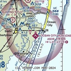
| Sectional chart |
|---|
|
| Airport distance calculator |
|---|
|
|
| Sunrise and sunset |
|---|
|
Times for 16-May-2025
| | Local
(UTC-4) | | Zulu
(UTC) |
|---|
| Morning civil twilight | | 05:20 | | 09:20 |
| Sunrise | | 05:50 | | 09:50 |
| Sunset | | 20:04 | | 00:04 |
| Evening civil twilight | | 20:34 | | 00:34 |
|
| Current date and time |
|---|
| Zulu (UTC) | 17-May-2025 00:16:11 |
|---|
| Local (UTC-4) | 16-May-2025 20:16:11 |
|---|
|
| METAR |
|---|
| KOXB | 162355Z AUTO 21006KT 4SM -TSRA BR FEW012 BKN028 OVC100 19/18 A2981 RMK AO2 LTG DSNT ALQDS PRESFR P0000 T01940183
|
KSBY
18nm W | 162354Z 09006KT 10SM FEW019 FEW040 19/18 A2977 RMK AO2 PK WND 25048/2306 LTG DSNT N-SE RAB03E36 TSB00E47 SLP082 P0046 60046 T01940183 10311 20189 53007
|
|
| TAF |
|---|
KSBY
18nm W | 162142Z 1622/1718 12008KT P6SM BKN050 TEMPO 1622/1624 VRB20G45KT 1SM +TSRA OVC035CB FM170100 20005KT P6SM BKN050 FM170300 22005KT P6SM VCSH BKN050 FM171300 22010KT P6SM BKN250 FM171700 24014G23KT P6SM SCT050
|
|
| NOTAMs |
|---|
NOTAMs are issued by the DoD/FAA and will open in a separate window not controlled by AirNav.
|
|


