FAA INFORMATION EFFECTIVE 27 NOVEMBER 2025
Location
| FAA Identifier: | RSW |
| Lat/Long: | 26-32-10.1900N 081-45-18.5580W
26-32.169833N 081-45.309300W
26.5361639,-81.7551550
(estimated) |
| Elevation: | 29.9 ft. / 9.1 m (surveyed) |
| Variation: | 04W (2000) |
| From city: | 10 miles SE of FORT MYERS, FL |
| Time zone: | UTC -5 (UTC -4 during Daylight Saving Time) |
| Zip code: | 33913 |
Airport Operations
| Airport use: | Open to the public |
| Activation date: | 03/1983 |
| Control tower: | yes |
| ARTCC: | MIAMI CENTER |
| FSS: | MIAMI FLIGHT SERVICE STATION |
| NOTAMs facility: | RSW (NOTAM-D service available) |
| Attendance: | 0700-0100 |
| Wind indicator: | lighted |
| Segmented circle: | yes |
| Lights: | ACTVT MALSR RWY 06 - CTAF. ALL OTHER LGTS OPR CONSLY. |
| Beacon: | white-green (lighted land airport)
Operates sunset to sunrise. |
| Landing fee: | yes, FEES FOR CHARTER, TRAVEL CLUBS & REVENUE PRODUCING ACFT. |
| Fire and rescue: | ARFF index D |
| International operations: | customs landing rights airport
US CUSTOMS USER FEE ARPT. |
Airport Communications
| CTAF: | 128.75 |
| UNICOM: | 122.95 |
| WX ASOS: | 124.65 (239-416-1031) |
| FORT MYERS GROUND: | 121.9 257.8 [0600-0000] |
| FORT MYERS TOWER: | 128.75 257.8 [0600-0000] |
| FORT MYERS APPROACH: | 119.75 ;181-240 124.125 ;121-180 125.15 ;RWY 06 126.8 ;001-120 126.8 ;RWY 24 127.05 ;301-360 134.425 ;241-300 306.2 ;241-120 306.2 371.85 ;121-240 [0600-0000] |
| FORT MYERS DEPARTURE: | 119.75 ;181-240 124.125 ;121-180 126.8 ;001-120 127.05 ;301-360 134.425 ;241-300 306.2 ;241-120 306.2 371.85 ;121-240 [0600-0000] |
| CLEARANCE DELIVERY: | 132.075 |
| ALICO DP: | 126.8 ;RWY 06 134.425 ;RWY 24 306.2 ;RWY 06/24 |
| CLASS C: | 119.75 ;181-240 124.125 ;121-180 126.8 ;001-120 127.05 ;301-360 134.425 ;241-300 306.2 ;241-120 371.85 ;121-240 |
| CSHEL DP: | 126.8 ;RWY 06 134.425 ;RWY 24 306.2 ;RWY 06/24 |
| D-ATIS: | 124.65 |
| IC: | 125.15 ;RWY 06 126.8 ;RWY 24 306.2 |
| JOSFF STAR: | 134.425 306.2 |
| MOOKY DP: | 124.125 ;RWY 06 134.425 ;RWY 24 306.2 ;RWY 24 371.85 ;RWY 06 |
| PUMPP STAR: | 134.425 306.2 |
| SCUBY DP: | 119.75 ;RWY 24 124.125 ;RWY 06 371.85 |
| SHFTY STAR: | 126.8 |
| TYNEE STAR: | 134.425 306.2 |
| WX ASOS at FMY (7 nm NW): | 123.725 (239-936-2318) |
- APCH/DEP SVC PRVDD BY MIAMI ARTCC ON FREQS 134.75/322.5 (FORT MYERS RCAG) WHEN FORT MYERS APCH CTL CLSD.
Nearby radio navigation aids
| VOR radial/distance | | VOR name | | Freq | | Var |
|---|
| RSWr073/1.2 | | LEE COUNTY VORTAC | | 114.15 | | 02W |
| NDB name | | Hdg/Dist | | Freq | | Var | | ID |
|---|
| CALOO | | 086/10.5 | | 341 | | 03W | | FM | ..-. -- |
Airport Services
| Fuel available: | 100LL JET-A JET-A+ |
| Parking: | hangars and tiedowns |
| Airframe service: | MAJOR |
| Powerplant service: | MAJOR |
| Bottled oxygen: | HIGH/LOW |
| Bulk oxygen: | HIGH/LOW |
Runway Information
Runway 6/24
| Dimensions: | 12000 x 150 ft. / 3658 x 46 m |
| Surface: | asphalt/grooved, in fair condition |
| Weight bearing capacity: | | Single wheel: | 120.0 | | Double wheel: | 250.0 | | Double tandem: | 550.0 | | Dual double tandem: | 1120.0 |
|
| Runway edge lights: | high intensity |
| RUNWAY 6 | | RUNWAY 24 |
| Latitude: | 26-31.589148N | | 26-32.750437N |
| Longitude: | 081-46.201153W | | 081-44.417290W |
| Elevation: | 26.6 ft. | | 29.8 ft. |
| Traffic pattern: | right | | left |
| Runway heading: | 058 magnetic, 054 true | | 238 magnetic, 234 true |
| Markings: | precision, in good condition | | precision, in good condition |
| Visual slope indicator: | 4-light PAPI on left (3.00 degrees glide path) | | 4-light PAPI on left (3.00 degrees glide path) |
| RVR equipment: | touchdown | | rollout |
| Approach lights: | MALSR: 1,400 foot medium intensity approach lighting system with runway alignment indicator lights | | |
| Runway end identifier lights: | | | yes |
| Centerline lights: | yes | | yes |
| Touchdown point: | yes, lighted | | yes, no lights |
| Instrument approach: | ILS/DME | | |
Airport Ownership and Management from official FAA records
| Ownership: | Publicly-owned |
| Owner: | BOARD OF COM LEE CO PORT AUTH
PO BOX 398
FORT MYERS, FL 33902
Phone 239-590-4800 |
| Manager: | STEVEN HENNIGAN, C.M., A.C.E.
11000 TERMINAL ACCESS RD.
FORT MYERS, FL 33913
Phone 239-590-4810 |
Additional Remarks
| A39-06/24 | PCR VALUE: 740/F/A/X/T |
| - | CAUTION: OPEN BAGGAGE BAYS & CONST WITHIN TERMINAL RAMP AREA. AIRCREWS USE MINIMUM THRUST SETTINGS IN THESE AREAS, SPCLY DURG SINGLE ENG TAXI. CROSS-BLEED STARTS ONLY ALLOWED AFT REACHING THE TUG RELEASE POINT. |
| - | TFC PROCD DRCTLY TO GATE UNLESS DRCTD BY ATC; ADVISE ATC IF GATE IS NOT AVBL. |
| - | DEP - ACFT MUST OBTAIN APVL FM GND CTL PRIOR TO PUSHBACK FM GATES B7, B9, C8, C9, D9 AND D11. PILOTS ADVISE TUG OPRS THAT YOU HAVE OBTAINED CLNC FM GND CTL PRIOR TO ENTERING TWY G. |
| - | GATES B7 & B9 EXP CALL SPOT 7. GATES C8 & C9 EXP CALL SPOT 4. |
| - | FOR CD IFUN TO CTC ON MIAMI CTR FREQ, CTC MIAMI ARTCC AT 305-716-1731 (0100-0700). |
| - | TWY A5 BTN FBO RAMP AND TWY A CLSD TO ACFT WINGSPAN MORE THAN 118 FT. |
| - | CAUTION: GS ANT 130 FT SW OF TWY A CNTRLN BTN TWY A1 & TWY A2. |
| - | OPERATE TRANSPONDERS WITH ALTITUDE REPORTING MODE AND ADS-B (IF EQUIPPED) ENABLED ON ALL AIRPORT SURFACES. |
| - | ALL ACFT ON RAMP EXP CLKWS FLOW. OBND TFC FM GATES D6, D8 & D10 PCD TO CALL SPOT 1; GATES D9 AND D11 EXP CALL SPOT 2. OBND TFC FM GATES C2, C4, C6, D1, D3, D5 & D7 PCD TO CALL SPOT 3; OBND TFC FM GATES B2, B4, B6, B8, C1, C3, C5 & C7 PCD TO CALL SPOT 5; OBND TFC FM GATES B1, B3 & B5 PCD TO CALL SPOT 9; ALL OBND TFC REQ TAXI INSTRUCTIONS. |
| - | NO HELI OPS PERMITTED ON TRML APRON. |
| - | LGTS ON PARALLEL ROAD & PARKING LOT NW OF RWY 06/24 CAN BE MISTAKEN FOR RWY & APCH ENVIRONMENT. |
| - | GND CLNC RQRD PRIOR TO ENTERING TWY G. |
| - | RWY USE PROGRAM IN EFFECT; USE DISTANT NOISE ABATEMENT DEP PROFILE. VISUAL APCH TO RWY 06 W OF FORT MYERS BEACH MAINTAIN 3000 FT UNTIL CROSSING SHORELINE 12 NM SW OF ARPT. RWY 24 PREFERRED BTN 2200-0600. FOR NOISE ABATEMENT PROC CTC AMGR. |
Instrument Procedures
NOTE: All procedures below are presented as PDF files. If you need a reader for these files, you should download the free Adobe Reader.NOT FOR NAVIGATION. Please procure official charts for flight.
FAA instrument procedures published for use from 27 November 2025 at 0901Z to 25 December 2025 at 0900Z.
STARs - Standard Terminal Arrivals |
|---|
| PUMPP TWO | |
download (132KB) |
| SHFTY SIX (RNAV) | |
2 pages:
[1] [2] (474KB) |
| TYNEE FOUR (RNAV) | |
2 pages:
[1] [2] (386KB) |
IAPs - Instrument Approach Procedures |
|---|
| ILS OR LOC RWY 06 | |
download (278KB) |
| RNAV (RNP) Z RWY 06 | |
download (246KB) |
| RNAV (RNP) Z RWY 24 | |
download (209KB) |
| RNAV (GPS) Y RWY 06 | |
download (294KB) |
| RNAV (GPS) Y RWY 24 | |
download (241KB) |
| VOR OR TACAN RWY 24 | |
download (222KB) |
| NOTE: Special Alternate Minimums apply | |
download (147KB) |
Departure Procedures |
|---|
| ALICO SEVEN | |
download (189KB) |
| CSHEL SEVEN (RNAV) | |
2 pages:
[1] [2] (380KB) |
| MOOKY SIX | |
download (164KB) |
| SCUBY EIGHT | |
download (168KB) |
| NOTE: Special Take-Off Minimums/Departure Procedures apply | |
download (162KB) |
Other nearby airports with instrument procedures:
KFMY - Page Field Airport (7 nm NW)
KIMM - Immokalee Regional Airport (20 nm E)
X14 - La Belle Municipal Airport (21 nm NE)
KAPF - Naples Municipal Airport (23 nm S)
KPGD - Punta Gorda Airport (26 nm NW)
|
|

Road maps at:
MapQuest
Bing
Google
| Aerial photo |
|---|
WARNING: Photo may not be current or correct
 Photo by Dave Fogarty ATP/CFI-MEI
Photo taken 15-Sep-2017
looking northeast at 3,500'.
Photo by Dave Fogarty ATP/CFI-MEI
Photo taken 15-Sep-2017
looking northeast at 3,500'.
Do you have a better or more recent aerial photo of Southwest Florida International Airport that you would like to share? If so, please send us your photo.
|
| Sectional chart |
|---|
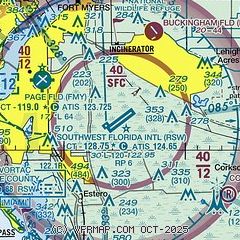
|
 Download PDF
of official airport diagram from the FAA
| Airport distance calculator |
|---|
|
|
| Sunrise and sunset |
|---|
|
Times for 20-Dec-2025
| | Local
(UTC-5) | | Zulu
(UTC) |
|---|
| Morning civil twilight | | 06:46 | | 11:46 |
| Sunrise | | 07:11 | | 12:11 |
| Sunset | | 17:38 | | 22:38 |
| Evening civil twilight | | 18:03 | | 23:03 |
|
| Current date and time |
|---|
| Zulu (UTC) | 20-Dec-2025 18:30:59 |
|---|
| Local (UTC-5) | 20-Dec-2025 13:30:59 |
|---|
|
| METAR |
|---|
| KRSW | 201753Z 00000KT 10SM CLR 27/12 A3010 RMK AO2 SLP191 T02670117 10267 20139 58025 $
|
KFMY
7nm NW | 201753Z 34003KT 10SM CLR 26/11 A3010 RMK AO2 SLP194 T02610106 10261 20128 58023 $
|
KIMM
20nm E | 201815Z AUTO 00000KT 10SM CLR 26/17 A3008 RMK AO2
|
|
| TAF |
|---|
| KRSW | 201720Z 2018/2118 05005KT P6SM FEW250 FM210900 VRB03KT 6SM BR SCT008 TEMPO 2110/2113 2SM BR FM211400 06005KT P6SM FEW025
|
KFMY
7nm NW | 201720Z 2018/2118 34005KT P6SM FEW250 FM210900 VRB03KT 6SM BR SCT008 TEMPO 2110/2113 2SM BR FM211400 06005KT P6SM SCT025
|
|
| NOTAMs |
|---|
NOTAMs are issued by the DoD/FAA and will open in a separate window not controlled by AirNav.
|
|


