FAA INFORMATION EFFECTIVE 12 JUNE 2025
Location
| FAA Identifier: | TGC |
| Lat/Long: | 35-55-56.8370N 088-50-56.1850W
35-55.947283N 088-50.936417W
35.9324547,-88.8489403
(estimated) |
| Elevation: | 358.4 ft. / 109.2 m (surveyed) |
| Variation: | 02W (2020) |
| From city: | 5 miles SE of TRENTON, TN |
| Time zone: | UTC -5 (UTC -6 during Standard Time) |
| Zip code: | 38358 |
Airport Operations
| Airport use: | Open to the public |
| Control tower: | no |
| ARTCC: | MEMPHIS CENTER |
| FSS: | JACKSON FLIGHT SERVICE STATION |
| NOTAMs facility: | MKL (NOTAM-D service available) |
| Attendance: | MON-SAT 0800-1630 |
| Wind indicator: | lighted |
| Segmented circle: | yes |
| Lights: | SS-SR |
| Beacon: | white-green (lighted land airport)
Operates sunset to sunrise. |
Airport Communications
- APCH/DEP SVC PRVDD BY MEMPHIS ARTCC ON FREQS 134.65/316.15 (MCKELLAR RCAG).
Nearby radio navigation aids
| VOR radial/distance | | VOR name | | Freq | | Var |
|---|
| MKLr010/20.0 | | MC KELLAR VOR/DME | | 114.85 | | 01W |
Airport Services
| Fuel available: | 100LL JET-A+
100LL:SELF SERVICE AVAILABLE 24/7 WITH CREDIT CARD. |
| Parking: | hangars and tiedowns |
Runway Information
Runway 1/19
| Dimensions: | 4802 x 75 ft. / 1464 x 23 m |
| Surface: | asphalt, in good condition |
| Weight bearing capacity: | |
| Runway edge lights: | medium intensity |
| RUNWAY 1 | | RUNWAY 19 |
| Latitude: | 35-55.556222N | | 35-56.338162N |
| Longitude: | 088-51.011577W | | 088-50.861455W |
| Elevation: | 358.0 ft. | | 355.1 ft. |
| Traffic pattern: | left | | left |
| Runway heading: | 011 magnetic, 009 true | | 191 magnetic, 189 true |
| Markings: | nonprecision, in good condition | | nonprecision, in good condition |
| Visual slope indicator: | 2-light PAPI on left (3.00 degrees glide path) | | 2-light PAPI on left (3.00 degrees glide path) |
| Runway end identifier lights: | yes | | yes |
| Touchdown point: | yes, no lights | | yes, no lights |
| Obstructions: | 17 ft. tree, 284 ft. from runway, 37 ft. right of centerline, 4:1 slope to clear | | 102 ft. tree, 1379 ft. from runway, 256 ft. left of centerline, 11:1 slope to clear |
Airport Ownership and Management from official FAA records
| Ownership: | Publicly-owned |
| Owner: | GIBSON COUNTY
ONE COURT SQUARE, SUITE 200
TRENTON, TN 38382
Phone 731-855-7613 |
| Manager: | ART HOPPERS
56 AIRPORT RD
MILAN, TN 38358
Phone 731-723-9596 |
Additional Remarks
| - | FOR CD CTC MEMPHIS ARTCC AT 901-368-8453/8449. |
Instrument Procedures
NOTE: All procedures below are presented as PDF files. If you need a reader for these files, you should download the free Adobe Reader.NOT FOR NAVIGATION. Please procure official charts for flight.
FAA instrument procedures published for use from 12 June 2025 at 0901Z to 10 July 2025 at 0900z.
IAPs - Instrument Approach Procedures |
|---|
| RNAV (GPS) RWY 01 | |
download (216KB) |
| RNAV (GPS) RWY 19 | |
download (218KB) |
| NOTE: Special Take-Off Minimums/Departure Procedures apply | |
download (272KB) |
Other nearby airports with instrument procedures:
M53 - Humboldt Municipal Airport (8 nm S)
KMKL - Jackson Regional Airport (20 nm S)
KHZD - Carroll County Airport (21 nm NE)
KDYR - Dyersburg Regional Airport (27 nm W)
KUCY - Everett-Stewart Regional Airport (28 nm N)
|
|

Road maps at:
MapQuest
Bing
Google
| Aerial photo |
|---|
WARNING: Photo may not be current or correct
 Photo taken 03-Nov-2007
from FL270
Photo taken 03-Nov-2007
from FL270
Do you have a better or more recent aerial photo of Gibson County Airport that you would like to share? If so, please send us your photo.
|
| Sectional chart |
|---|
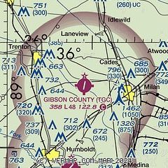
|
| Airport distance calculator |
|---|
|
|
| Sunrise and sunset |
|---|
|
Times for 25-Jun-2025
| | Local
(UTC-5) | | Zulu
(UTC) |
|---|
| Morning civil twilight | | 05:11 | | 10:11 |
| Sunrise | | 05:41 | | 10:41 |
| Sunset | | 20:15 | | 01:15 |
| Evening civil twilight | | 20:45 | | 01:45 |
|
| Current date and time |
|---|
| Zulu (UTC) | 25-Jun-2025 05:52:40 |
|---|
| Local (UTC-5) | 25-Jun-2025 00:52:40 |
|---|
|
| METAR |
|---|
KMKL
20nm S | 250453Z AUTO 00000KT 8SM CLR 26/24 A3020 RMK AO1 SLP222 T02560244 $
|
KHZD
21nm NE | 250515Z AUTO 00000KT 9SM CLR 25/25 A3019 RMK A01
|
KDYR
27nm W | 250456Z AUTO 00000KT 10SM CLR 26/ A3020 RMK AO2 SLP229 T0261
|
KUCY
28nm N | 250510Z AUTO 00000KT 10SM CLR 25/25 A3017 RMK A01
|
KPHT
33nm NE | 250515Z AUTO 00000KT 10SM CLR 25/25 A3019 RMK A01
|
|
| TAF |
|---|
KMKL
20nm S | 241725Z 2418/2518 20004KT P6SM SCT045 FM250100 00000KT P6SM SKC FM251600 22004KT P6SM FEW035
|
|
| NOTAMs |
|---|
NOTAMs are issued by the DoD/FAA and will open in a separate window not controlled by AirNav.
|
|


