FAA INFORMATION EFFECTIVE 11 JUNE 2026
Location
| FAA Identifier: | TTD |
| Lat/Long: | 45-32-57.7000N 122-24-04.5000W
45-32.961667N 122-24.075000W
45.5493611,-122.4012500
(estimated) |
| Elevation: | 38.9 ft. / 11.9 m (surveyed) |
| Variation: | 16E (2015) |
| From city: | 10 miles E of PORTLAND, OR |
| Time zone: | UTC -7 (UTC -8 during Standard Time) |
| Zip code: | 97060 |
Airport Operations
| Airport use: | Open to the public |
| Activation date: | 02/1939 |
| Control tower: | yes |
| ARTCC: | SEATTLE CENTER |
| FSS: | MC MINNVILLE FLIGHT SERVICE STATION |
| NOTAMs facility: | TTD (NOTAM-D service available) |
| Attendance: | 0700-2200 |
| Wind indicator: | lighted |
| Segmented circle: | yes |
| Lights: | ACTVT MIRL RY 07/25 - CTAF. RY 07 VASI & RY 25 PAPI OPER CONT. |
| Beacon: | white-green (lighted land airport)
Operates sunset to sunrise. |
| Landing fee: | yes, COMMERCIAL ACFT & OPERATORS OF ACFT WITH AN FAA CERTIFIED MAX GROSS LANDING WEIGHT THAT EXCEEDS 10000 LBS ARE REQUIRED TO PAY A LANDING FEE. |
Airport Communications
| CTAF: | 120.9 |
| UNICOM: | 122.95 |
| ATIS: | 135.625 |
| WX ASOS: | 135.625 (503-492-2887) |
| TROUTDALE GROUND: | 121.8 [0700-2200] |
| TROUTDALE TOWER: | 120.9 254.3 [0700-2200] |
| PORTLAND APPROACH: | 118.1 ;100-279, HIGH 124.35 |
| PORTLAND DEPARTURE: | 124.35 |
| HELNS STAR: | 124.35 |
| OCITY STAR: | 124.35 |
| WX ASOS at PDX (9 nm W): | PHONE 458-212-2405 |
| WX ASOS at VUO (12 nm W): | 135.125 (360-696-1280) |
Nearby radio navigation aids
| VOR radial/distance | | VOR name | | Freq | | Var |
|---|
| BTGr125/14.3 | | BATTLE GROUND VORTAC | | 116.60 | | 21E |
| UBGr043/27.0 | | NEWBERG VOR/DME | | 117.40 | | 21E |
| NDB name | | Hdg/Dist | | Freq | | Var | | ID |
|---|
| BANKS | | 084/27.5 | | 356 | | 16E | | PND | .--. -. -.. |
Airport Services
| Fuel available: | 100LL JET-A |
| Parking: | hangars and tiedowns |
| Airframe service: | MAJOR |
| Powerplant service: | MAJOR |
| Bottled oxygen: | NONE |
| Bulk oxygen: | HIGH |
Runway Information
Runway 7/25
| Dimensions: | 5399 x 150 ft. / 1646 x 46 m |
| Surface: | asphalt, in good condition |
| Weight bearing capacity: | | Single wheel: | 19.0 | | Double wheel: | 25.0 |
|
| Runway edge lights: | medium intensity |
| RUNWAY 7 | | RUNWAY 25 |
| Latitude: | 45-32.951990N | | 45-32.972372N |
| Longitude: | 122-24.707093W | | 122-23.443107W |
| Elevation: | 27.8 ft. | | 38.9 ft. |
| Traffic pattern: | left | | left |
| Runway heading: | 073 magnetic, 089 true | | 253 magnetic, 269 true |
| Displaced threshold: | no | | 353 ft. |
| Declared distances: | | | TORA:5399 TODA:5399 ASDA:5399 LDA:5046 |
| Markings: | nonprecision, in good condition | | nonprecision, in good condition |
| Visual slope indicator: | 4-box VASI on left (3.00 degrees glide path) | | 4-light PAPI on left (3.10 degrees glide path)
RY 25 PAPI IS BAFFLED 08 DEG L AND R OF CNTRLN. |
| Runway end identifier lights: | yes | | yes |
| Touchdown point: | yes, no lights | | yes, no lights |
| Obstructions: | 105 ft. trees, 2100 ft. from runway, 18:1 slope to clear
APCH CLNC SLOPE FROM DTHR IS 45:1 BASED ON 21' ROAD AT 817'. | | 63 ft. trees, 1653 ft. from runway, 23:1 slope to clear
APCH RATIO 27:1; DIKE AT 588' LGTD. |
Airport Ownership and Management from official FAA records
| Ownership: | Publicly-owned |
| Owner: | THE PORT OF PORTLAND
BOX 3529
PORTLAND, OR 97208
Phone 503-944-7000 |
| Manager: | KAMA SIMONDS
PORT OF PORTLAND BOX 3529
PORTLAND, OR 97208
Phone 503-415-6119 |
Additional Remarks
| - | MIGRATORY FLOCKSOF WATERFOWL ON & INVOF ARPT. |
| - | FOR CD CTC PORTLAND APCH AT 503-493-7545. |
| - | PORTLAND INTL ARPT RY 10L/28R EXTNDD CENTERLINE CROSSES ARPT, ATCT MAY ISSUE RESTRICCTIONS DUE TO PDX TFC. |
| - | NOISE ABATEMENT PROCEDURES IN EFFECT. CALL 503-460-4100 OR 800-938-6647. |
| - | NOISE SENSITIVE AREAS BORDER THE ARPT WEST AND SOUTH. |
| - | AVOID LOW-LEVEL OVERFLIGHTS OF RESIDENTIAL AREAS. |
| - | RECOMMEND BETWEEN SS AND SR, RY 7 LEFT TFC AND RY 25 RIGHT TFC DUE TO BLUFF 5000 FT SOUTH OF ARPT. |
| - | EXTENSIVE HELICOPTER OPS ON AND ADJACENT TO WEST ENDS OF THE PARALLEL TWYS, NO EARLY TURNOUTS. |
| - | MULTIPLE CONST CRANES 110 FT AGL OR BLO LOCATED 2700 FT SW OF RY 25 THLD. |
Instrument Procedures
NOTE: All procedures below are presented as PDF files. If you need a reader for these files, you should download the free Adobe Reader.NOT FOR NAVIGATION. Please procure official charts for flight.
FAA instrument procedures published for use from 11 June 2026 at 0901Z to 09 July 2026 at 0900z.
IAPs - Instrument Approach Procedures |
|---|
| RNAV (GPS)-A | |
download (187KB) |
| NOTE: Special Alternate Minimums apply | |
download (59KB) |
Departure Procedures |
|---|
| BLUE LAKE THREE | |
download (190KB) |
| NOTE: Special Take-Off Minimums/Departure Procedures apply | |
download (394KB) |
Other nearby airports with instrument procedures:
KPDX - Portland International Airport (9 nm W)
KVUO - Pearson Field Airport (12 nm W)
KHIO - Portland-Hillsboro Airport (23 nm W)
KSPB - Scappoose Airport (23 nm NW)
KUAO - Aurora State Airport (24 nm SW)
|
|

Road maps at:
MapQuest
Bing
Google
| Aerial photo |
|---|
WARNING: Photo may not be current or correct
 Photo taken 03-Sep-2008
on a 1/2 mile final for runway 25, shows taxiway B expansion and widening in progress
Photo taken 03-Sep-2008
on a 1/2 mile final for runway 25, shows taxiway B expansion and widening in progress
Do you have a better or more recent aerial photo of Portland-Troutdale Airport that you would like to share? If so, please send us your photo.
|
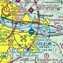
| Sectional chart |
|---|
|
CAUTION: Diagram may not be current
 Download PDF
of official airport diagram from the FAA
| Airport distance calculator |
|---|
|
|
| Sunrise and sunset |
|---|
|
Times for 11-Jun-2026
| | Local
(UTC-7) | | Zulu
(UTC) |
|---|
| Morning civil twilight | | 04:44 | | 11:44 |
| Sunrise | | 05:21 | | 12:21 |
| Sunset | | 20:57 | | 03:57 |
| Evening civil twilight | | 21:35 | | 04:35 |
|
| Current date and time |
|---|
| Zulu (UTC) | 11-Jun-2026 13:25:45 |
|---|
| Local (UTC-7) | 11-Jun-2026 06:25:45 |
|---|
|
| METAR |
|---|
| KTTD | 111253Z AUTO 11003KT 10SM CLR 07/06 A3018 RMK AO2 SLP220 T00720061
|
KPDX
9nm W | 111253Z 00000KT 10SM CLR 10/08 A3018 RMK AO2 SLP219 T01000078 $
|
KVUO
11nm W | 111253Z AUTO 00000KT 10SM CLR 09/08 A3020 RMK AO2 SLP225 T00940078
|
|
| TAF |
|---|
| KTTD | 111120Z 1112/1212 VRB04KT P6SM SKC
|
KPDX
9nm W | 111120Z 1112/1212 33005KT P6SM SKC
|
|
| NOTAMs |
|---|
NOTAMs are issued by the DoD/FAA and will open in a separate window not controlled by AirNav.
|
|


