FAA INFORMATION EFFECTIVE 14 MAY 2026
Location
| FAA Identifier: | TYQ |
| Lat/Long: | 40-01-42.9940N 086-15-05.0600W
40-01.716567N 086-15.084333W
40.0286094,-86.2514056
(estimated) |
| Elevation: | 922.2 ft. / 281.1 m (surveyed) |
| Variation: | 03W (1995) |
| From city: | 14 miles NW of INDIANAPOLIS, IN |
| Time zone: | UTC -4 (UTC -5 during Standard Time) |
| Zip code: | 46077 |
Airport Operations
| Airport use: | Open to the public |
| Control tower: | no |
| ARTCC: | INDIANAPOLIS CENTER |
| FSS: | TERRE HAUTE FLIGHT SERVICE STATION |
| NOTAMs facility: | HUF (NOTAM-D service available) |
| Attendance: | 0600-2000
SVC AFT HR - 317-769-4487. |
| Wind indicator: | lighted |
| Segmented circle: | no |
| Lights: | ACTVT REIL RWY 18 & 36; HIRL RWY 18/36 - CTAF. HIRL RWY 18/36 PRESET MED INTST DUSK - DAWN; INCR INTST- CTAF. PAPI RWY 18 & 36 OPR CONSLY. |
| Beacon: | white-green (lighted land airport)
Operates sunset to sunrise. |
Airport Communications
| CTAF/UNICOM: | 123.05 |
| WX AWOS-3PT: | 120.725 (317-769-3154) |
| INDIANAPOLIS APPROACH: | 124.65 ;ACTIVE RWY 05/23 AT IND 127.15 ;ACTIVE RWY 14/32 AT IND |
| INDIANAPOLIS DEPARTURE: | 124.65 ;ACTIVE RWY 05/23 AT IND 127.15 ;ACTIVE RWY 14/32 AT IND |
| CLEARANCE DELIVERY: | 118.175 |
| CLANG RNAV STAR: | 128.175 |
| RACYR STAR: | 128.175 |
| WX AWOS-3PT at UMP (11 nm SE): | 119.375 (317-842-3911) |
| WX ASOS at EYE (12 nm S): | 121.575 (317-329-1754) |
| WX AWOS-3 at 8A4 (16 nm S): | 135.525 (317-955-3160) |
| WX ASOS at IND (19 nm S): | PHONE 317-220-6243 |
| WX AWOS-3PT at MQJ (20 nm SE): | 124.175 (317-335-3037) |
| WX AWOS-3PT at 2R2 (20 nm SW): | 118.025 (317-718-4872) |
- APCH/DEP SVC PRVDD BY INDIANAPOLIS ATCT/TRACON ON 124.65 (ACTIVE RWY 05/23 AT IND) AND 127.15 (ACTIVE RWY 14/32 AT IND) AND ON 317.8.
Nearby radio navigation aids
| VOR radial/distance | | VOR name | | Freq | | Var |
|---|
| VHPr022/13.9 | | BRICKYARD VORTAC | | 116.30 | | 01E |
| SHBr319/30.9 | | SHELBYVILLE VOR/DME | | 116.15 | | 01E |
| MZZr226/38.3 | | MARION VOR/DME | | 108.60 | | 03W |
| NDB name | | Hdg/Dist | | Freq | | Var | | ID |
|---|
| CRAWFORDSVILLE | | 089/30.7 | | 388 | | 04W | | CFJ | -.-. ..-. .--- |
Airport Services
| Fuel available: | 100LL JET-A JET-A+
100LL:100LL SELF SVC H24 WITH CREDIT CARD. |
| Parking: | hangars and tiedowns |
| Airframe service: | MAJOR |
| Powerplant service: | MAJOR |
| Bottled oxygen: | HIGH |
| Bulk oxygen: | HIGH/LOW |
Runway Information
Runway 18/36
| Dimensions: | 7001 x 100 ft. / 2134 x 30 m |
| Surface: | concrete/grooved, in excellent condition |
| Weight bearing capacity: | | PCN 37 /R/B/W/T | | Single wheel: | 45.0 | | Double wheel: | 90.0 |
|
| Runway edge lights: | high intensity |
| Operational restrictions: | RWY 36 CALM/XWIND RWY. |
| RUNWAY 18 | | RUNWAY 36 |
| Latitude: | 40-02.293083N | | 40-01.140047N |
| Longitude: | 086-15.091233W | | 086-15.077447W |
| Elevation: | 921.9 ft. | | 921.9 ft. |
| Traffic pattern: | left | | left |
| Runway heading: | 182 magnetic, 179 true | | 002 magnetic, 359 true |
| Markings: | nonprecision, in good condition | | precision, in good condition |
| Visual slope indicator: | 4-light PAPI on left (3.00 degrees glide path) | | 4-light PAPI on left (3.00 degrees glide path) |
| Runway end identifier lights: | yes | | yes |
| Touchdown point: | yes, no lights | | yes, no lights |
| Instrument approach: | | | ILS |
| Obstructions: | 24 ft. hangar, 670 ft. from runway, 540 ft. right of centerline, 19:1 slope to clear
10 FT CROPS 230 FT E OF RWY CNTRLN. | | 35 ft. tree, 1175 ft. from runway, 200 ft. right of centerline, 27:1 slope to clear |
Airport Ownership and Management from official FAA records
| Ownership: | Publicly-owned |
| Owner: | HAMILTON COUNTY AIRPORT AUTHORITY
11329 E. STATE RD 32
ZIONSVILLE, IN 46077
Phone (317) 385-3015 |
| Manager: | SAM SACHS
11329 E. STATE RD 32
ZIONSVILLE, IN 46077
Phone 317-385-3015 |
Additional Remarks
| - | BIRDS ON & INVOF ARPT |
| - | FOR CD CTC INDIANAPOLIS APCH AT 317-227-5743. |
| - | COND NOT MNT 2000-0600. |
| - | REMOTE CTL ACFT ACT 0.1 NM W OF RWY 18/36 SFC-400 FT. |
| - | FUEL & SVC - 130.4 |
Instrument Procedures
NOTE: All procedures below are presented as PDF files. If you need a reader for these files, you should download the free Adobe Reader.NOT FOR NAVIGATION. Please procure official charts for flight.
FAA instrument procedures published for use from 14 May 2026 at 0901Z to 11 June 2026 at 0900Z.
STARs - Standard Terminal Arrivals |
|---|
| CLANG ONE (RNAV) **NEW** | |
download (139KB) |
| RACYR SIX | |
download (204KB) |
IAPs - Instrument Approach Procedures |
|---|
| ILS OR LOC RWY 36 | |
download (189KB) |
| RNAV (GPS) RWY 18 | |
download (222KB) |
| RNAV (GPS) RWY 36 | |
download (199KB) |
| VOR RWY 18 | |
download (180KB) |
| NOTE: Special Alternate Minimums apply | |
download (168KB) |
Departure Procedures |
|---|
| DAWNN ONE | |
2 pages:
[1] [2] (256KB) |
| HOOSIER FIVE | |
download (190KB) |
| MAREO ONE (RNAV) **NEW** | |
download (140KB) |
| MEARZ SEVEN | |
download (192KB) |
| ROCKY ONE | |
download (204KB) |
| NOTE: Special Take-Off Minimums/Departure Procedures apply | |
download (470KB) |
Other nearby airports with instrument procedures:
5I4 - Sheridan Airport (9 nm N)
KUMP - Indianapolis Metro Airport (11 nm SE)
KEYE - Eagle Creek Airpark (12 nm S)
KIND - Indianapolis International Airport (19 nm S)
KMQJ - Indianapolis Regional Airport (20 nm SE)
2R2 - Hendricks County Airport-Gordon Graham Field (20 nm SW)
|
|

Road maps at:
MapQuest
Bing
Google
| Aerial photo |
|---|
WARNING: Photo may not be current or correct
 Photo by Tom Nasser
Taken in October 2008
Photo by Tom Nasser
Taken in October 2008
Do you have a better or more recent aerial photo of Indianapolis Executive Airport that you would like to share? If so, please send us your photo.
|
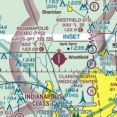
| Sectional chart |
|---|
|
CAUTION: Diagram may not be current

| Airport distance calculator |
|---|
|
|
| Sunrise and sunset |
|---|
|
Times for 08-Jun-2026
| | Local
(UTC-4) | | Zulu
(UTC) |
|---|
| Morning civil twilight | | 05:44 | | 09:44 |
| Sunrise | | 06:17 | | 10:17 |
| Sunset | | 21:11 | | 01:11 |
| Evening civil twilight | | 21:44 | | 01:44 |
|
| Current date and time |
|---|
| Zulu (UTC) | 08-Jun-2026 04:19:04 |
|---|
| Local (UTC-4) | 08-Jun-2026 00:19:04 |
|---|
|
| METAR |
|---|
| KTYQ | 080355Z AUTO 00000KT 4SM BR CLR 21/20 A2999 RMK AO2 T02100203 402990188
|
KUMP
11nm SE | 080355Z AUTO 00000KT 8SM BKN200 21/21 A2999 RMK AO2 T02100210
|
KEYE
12nm S | 080353Z AUTO 06004KT 10SM CLR 22/21 A2998 RMK AO2 SLP143 T02220206
|
KIND
19nm S | 080354Z 07006KT 10SM FEW160 SCT200 BKN250 24/21 A2998 RMK AO2 SLP143 T02440206
|
KMQJ
20nm SE | 080355Z AUTO 12003KT 10SM SCT047 BKN200 21/21 A2999 RMK AO2 T02130213
|
|
| TAF |
|---|
KIND
19nm S | 072151Z 0722/0824 09010KT P6SM VCTS BKN040CB PROB30 0722/0801 2SM TSRA OVC035CB FM080100 12005KT P6SM BKN040 FM081400 14009KT P6SM VCSH BKN020 OVC090 FM081700 18009KT P6SM VCSH OVC025 TEMPO 0819/0823 2SM -SHRA BR OVC015
|
|
| NOTAMs |
|---|
NOTAMs are issued by the DoD/FAA and will open in a separate window not controlled by AirNav.
|
|


