FAA INFORMATION EFFECTIVE 14 MAY 2026
Location
| FAA Identifier: | W52 |
| Lat/Long: | 45-49-36.4670N 122-34-36.6820W
45-49.607783N 122-34.611367W
45.8267964,-122.5768561
(estimated) |
| Elevation: | 292 ft. / 89 m (estimated) |
| Variation: | 20E (1985) |
| From city: | 3 miles NW of BATTLE GROUND, WA |
| Time zone: | UTC -7 (UTC -8 during Standard Time) |
| Zip code: | 98604 |
Airport Operations
| Airport use: | Open to the public |
| Activation date: | 02/1971 |
| Control tower: | no |
| ARTCC: | SEATTLE CENTER |
| FSS: | SEATTLE FLIGHT SERVICE STATION |
| NOTAMs facility: | SEA (NOTAM-D service available) |
| Attendance: | CONTINUOUS
OWNER LIVES ON ARPT. |
| Wind indicator: | yes |
| Segmented circle: | no |
| Lights: | ACTVT LIRL RY 15/33 - CTAF. |
Airport Communications
| CTAF: | 122.9 |
| WX ASOS at SPB (12 nm W): | 135.875 (503-543-6401) |
| WX ASOS at VUO (13 nm S): | 135.125 (360-696-1280) |
| WX ASOS at PDX (14 nm S): | PHONE 458-212-2405 |
| WX ASOS at TTD (18 nm SE): | 135.625 (503-492-2887) |
Nearby radio navigation aids
| VOR radial/distance | | VOR name | | Freq | | Var |
|---|
| BTGr346/4.8 | | BATTLE GROUND VORTAC | | 116.60 | | 21E |
| UBGr010/33.0 | | NEWBERG VOR/DME | | 117.40 | | 21E |
| NDB name | | Hdg/Dist | | Freq | | Var | | ID |
|---|
| BANKS | | 043/22.9 | | 356 | | 16E | | PND | .--. -. -.. |
Airport Services
| Parking: | tiedowns |
| Airframe service: | MAJOR |
| Powerplant service: | MAJOR |
| Bulk oxygen: | NONE |
Runway Information
Runway 15/33
| Dimensions: | 2565 x 50 ft. / 782 x 15 m
WIDTH OF 43' OVER CULVERT IN CENTER OF FIELD. |
| Surface: | turf, in good condition
SFC UNEVEN WITH AN INCLINE. |
| Runway edge lights: | low intensity |
| RUNWAY 15 | | RUNWAY 33 |
| Latitude: | 45-49.853517N | | 45-49.446333N |
| Longitude: | 122-34.721833W | | 122-34.563050W |
| Traffic pattern: | left | | left |
| Visual slope indicator: | non-standard VASI system
HAS NSTD SINGLE LIGHT VASI BOTH SIDES OF RY. | | |
| Obstructions: | 128 ft. trees, 770 ft. from runway, 6:1 slope to clear | | 35 ft. pline, lighted, 157 ft. from runway, 46 ft. left of centerline, 4:1 slope to clear |
Runway 7/25
| Dimensions: | 1500 x 48 ft. / 457 x 15 m |
| Surface: | turf, in good condition |
| RUNWAY 7 | | RUNWAY 25 |
| Traffic pattern: | left | | left |
| Obstructions: | 42 ft. tree, 870 ft. from runway, 20:1 slope to clear
3 MKR BALLS ON 45 FT PWR LINE 250 FT FM RWY END. | | 66 ft. tree, marked, 581 ft. from runway, 8:1 slope to clear |
Airport Ownership and Management from official FAA records
| Ownership: | Privately-owned |
| Owner: | GORDON GOHEEN
9304 NE 279 ST
BATTLE GROUND, WA 98604
Phone 360-687-3038 |
| Manager: | MARK SWONGER
9304 NE 279TH ST
BATTLE GROUND, WA 98604
Phone 360-687-3038
ALTN FONE NR 360-600-7949. |
Additional Remarks
| - | RY 07/25 FOR EMERGENCY USE ONLY. |
| - | HNGRS 61 FT AND 67 FT FM EDGE OF RWY 07. |
| - | RWY 25 6 FT FENCE, 16 FT FROM RWY END. |
| - | FOR CD CTC PORTLAND APCH AT 503-493-7545. |
| - | ROAD INTERSECTS RWY 07/25 AT MID-POINT. |
| - | RWY 07 END, BERM, 17 FT RIGHT. |
Instrument Procedures
There are no published instrument procedures at W52.
Some nearby airports with instrument procedures:
KSPB - Scappoose Airport (12 nm W)
KVUO - Pearson Field Airport (13 nm S)
KPDX - Portland International Airport (14 nm S)
KTTD - Portland-Troutdale Airport (18 nm SE)
KKLS - Southwest Washington Regional Airport (22 nm NW)
|
|

Road maps at:
MapQuest
Bing
Google
| Aerial photo |
|---|
WARNING: Photo may not be current or correct

Do you have a better or more recent aerial photo of Goheen Airport that you would like to share? If so, please send us your photo.
|
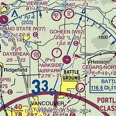
| Sectional chart |
|---|
|
| Airport distance calculator |
|---|
|
|
| Sunrise and sunset |
|---|
|
Times for 30-May-2026
| | Local
(UTC-7) | | Zulu
(UTC) |
|---|
| Morning civil twilight | | 04:49 | | 11:49 |
| Sunrise | | 05:26 | | 12:26 |
| Sunset | | 20:50 | | 03:50 |
| Evening civil twilight | | 21:27 | | 04:27 |
|
| Current date and time |
|---|
| Zulu (UTC) | 30-May-2026 11:57:54 |
|---|
| Local (UTC-7) | 30-May-2026 04:57:54 |
|---|
|
| METAR |
|---|
KSPB
13nm W | 301153Z AUTO 26003KT 10SM FEW039 04/03 A3024 RMK AO2 SLP239 T00440033 10106 20044 53009
|
KVUO
13nm S | 301153Z AUTO 00000KT 10SM CLR 06/04 A3026 RMK AO2 SLP247 70003 T00610039 10117 20056 53009
|
KPDX
15nm S | 301153Z 00000KT 10SM FEW250 08/04 A3025 RMK AO2 SLP241 70003 T00830039 10117 20078 53009 $
|
KTTD
18nm S | 301153Z AUTO 18003KT 10SM CLR 07/04 A3025 RMK AO2 SLP242 70001 T00670039 10117 20061 53012
|
KKLS
22nm NW | 301056Z AUTO 00000KT 10SM CLR 04/03 A3024 RMK AO2 SLP243 T00440028 PNO $
|
KHIO
23nm SW | 291453Z 33011KT 10SM OVC042 12/07 A2999 RMK AO2 SLP154 T01220072 51022
|
|
| TAF |
|---|
KPDX
15nm S | 300520Z 3006/3106 32008KT P6SM SCT050 SCT250 FM301400 30005KT P6SM BKN050 FM302000 31008KT P6SM SCT250
|
KTTD
18nm S | 300520Z 3006/3106 VRB06KT P6SM BKN050 FM302000 28005KT P6SM FEW050 BKN250
|
|
| NOTAMs |
|---|
NOTAMs are issued by the DoD/FAA and will open in a separate window not controlled by AirNav.
|
|

