FAA INFORMATION EFFECTIVE 11 JUNE 2026
Location
| FAA Identifier: | JVY |
| Lat/Long: | 38-21-59.8260N 085-44-17.3210W
38-21.997100N 085-44.288683W
38.3666183,-85.7381447
(estimated) |
| Elevation: | 477.7 ft. / 145.6 m (surveyed) |
| Variation: | 02W (1990) |
| From city: | 5 miles N of JEFFERSONVILLE, IN |
| Time zone: | UTC -4 (UTC -5 during Standard Time) |
| Zip code: | 47172 |
Airport Operations
| Airport use: | Open to the public |
| Activation date: | 12/1981 |
| Control tower: | no |
| ARTCC: | INDIANAPOLIS CENTER |
| FSS: | TERRE HAUTE FLIGHT SERVICE STATION |
| NOTAMs facility: | HUF (NOTAM-D service available) |
| Attendance: | 0600-2300 |
| Pattern altitude: | 1277.7 ft. MSL |
| Wind indicator: | lighted |
| Segmented circle: | yes |
| Lights: | REIL RWY 14 & 32; REIL RWY 36; MIRL RWY 18/36 & 14/32 OPR SS-SR AND PRESET MED INTST; TO INCR INTST AND ACTVT MALSR RWY 18 - CTAF. PAPI RWY 18 & 36; PAPI RWY 14 & 32 OPR CONSLY. |
| Beacon: | white-green (lighted land airport)
Operates sunset to sunrise. |
Airport Communications
| CTAF/UNICOM: | 122.7 |
| WX AWOS-3T: | 118.575 (812-246-1278) |
| LOUISVILLE APPROACH: | 132.075 |
| LOUISVILLE DEPARTURE: | 132.075 |
| CLEARANCE DELIVERY: | 118.05 |
| WX ASOS at LOU (9 nm SE): | PHONE 502-473-0693 |
| WX ASOS at SDF (12 nm S): | PHONE 502-676-6814 |
Nearby radio navigation aids
| VOR radial/distance | | VOR name | | Freq | | Var |
|---|
| IIUr333/17.5 | | LOUISVILLE VORTAC | | 114.80 | | 01E |
| FTKr023/29.7 | | FORT KNOX VOR/DME | | 109.60 | | 01W |
| MYSr041/(37.1) | | MYSTIC VOR | | 108.20 | | 01W |
| NDB name | | Hdg/Dist | | Freq | | Var | | ID |
|---|
| LAANG | | 344/14.2 | | 414 | | 04W | | LK | .-.. -.- |
| GODMAN | | 028/26.9 | | 396 | | 03W | | GOI | --. --- .. |
Airport Services
| Fuel available: | 100LL JET-A
A:AVBL 0600-2300, AFT HRS CALL AHD RQRD. |
| Parking: | hangars and tiedowns |
| Airframe service: | MAJOR |
| Powerplant service: | MAJOR |
| Bottled oxygen: | HIGH |
| Bulk oxygen: | HIGH |
Runway Information
Runway 18/36
| Dimensions: | 7000 x 100 ft. / 2134 x 30 m |
| Surface: | asphalt/grooved, in good condition |
| Weight bearing capacity: | | Single wheel: | 45.0 | | Double wheel: | 60.0 |
|
| Runway edge lights: | medium intensity |
| RUNWAY 18 | | RUNWAY 36 |
| Latitude: | 38-22.568543N | | 38-21.415240N |
| Longitude: | 085-44.273188W | | 085-44.272582W |
| Elevation: | 477.5 ft. | | 461.2 ft. |
| Traffic pattern: | left | | left |
| Runway heading: | 182 magnetic, 180 true | | 002 magnetic, 360 true |
| Markings: | precision, in good condition | | precision, in good condition |
| Visual slope indicator: | 4-light PAPI on left (3.00 degrees glide path) | | 4-light PAPI on left (3.00 degrees glide path) |
| Approach lights: | MALSR: 1,400 foot medium intensity approach lighting system with runway alignment indicator lights | | |
| Runway end identifier lights: | no | | yes |
| Touchdown point: | yes, no lights | | yes, no lights |
| Instrument approach: | ILS | | |
| Obstructions: | 70 ft. pline, 3150 ft. from runway, 894 ft. left of centerline, 42:1 slope to clear | | 36 ft. tree, 750 ft. from runway, 120 ft. left of centerline, 15:1 slope to clear |
Runway 14/32
| Dimensions: | 3899 x 75 ft. / 1188 x 23 m |
| Surface: | asphalt, in good condition |
| Weight bearing capacity: | |
| Runway edge lights: | medium intensity |
| RUNWAY 14 | | RUNWAY 32 |
| Latitude: | 38-22.245062N | | 38-21.767843N |
| Longitude: | 085-44.590125W | | 085-44.044013W |
| Elevation: | 468.8 ft. | | 460.9 ft. |
| Traffic pattern: | left | | left |
| Runway heading: | 140 magnetic, 138 true | | 320 magnetic, 318 true |
| Markings: | basic, in fair condition | | basic, in fair condition |
| Visual slope indicator: | 2-light PAPI on left (3.90 degrees glide path) | | 2-light PAPI on left (3.90 degrees glide path) |
| Runway end identifier lights: | yes | | yes |
| Touchdown point: | yes, no lights | | yes, no lights |
Airport Ownership and Management from official FAA records
| Ownership: | Publicly-owned |
| Owner: | SOUTH CENTRAL REGIONAL AIRPORT AUTH
6003 PROPELLER LANE
SELLERSBURG, IN 47172
Phone 812-246-7460 |
| Manager: | JOHN SECOR
6003 PROPELLER LANE
SELLERSBURG, IN 47172
Phone 812-246-7460 |
Additional Remarks
| - | STUDENT ACT & WILDLIFE ON & INVOF ARPT. |
| - | LNDG FEE FOR NON BASE ACFT. |
| - | EMERG PHONE LCTD N SIDE OF AUTH BLDG - CTAF TO OPEN. |
| - | FOR CD CTC LOUISVILLE APCH AT 502-375-7499 |
Instrument Procedures
NOTE: All procedures below are presented as PDF files. If you need a reader for these files, you should download the free Adobe Reader.NOT FOR NAVIGATION. Please procure official charts for flight.
FAA instrument procedures published for use from 11 June 2026 at 0901Z to 09 July 2026 at 0900z.
STARs - Standard Terminal Arrivals |
|---|
| JMONY TWO (RNAV) **NEW** | |
2 pages:
[1] [2] (361KB) |
| JMONY TWO (RNAV), CONT.2 **NEW** | |
download (361KB) |
| LEDDL ONE (RNAV) **NEW** | |
2 pages:
[1] [2] (514KB) |
| MBELL FIVE (RNAV) **NEW** | |
2 pages:
[1] [2] (593KB) |
IAPs - Instrument Approach Procedures |
|---|
| ILS OR LOC RWY 18 **CHANGED** | |
download (227KB) |
| RNAV (GPS) RWY 18 **CHANGED** | |
download (226KB) |
| RNAV (GPS) RWY 36 **CHANGED** | |
download (218KB) |
| NOTE: Special Alternate Minimums apply | |
download (168KB) |
| NOTE: Special Take-Off Minimums/Departure Procedures apply | |
download (331KB) |
Other nearby airports with instrument procedures:
KLOU - Bowman Field Airport (9 nm SE)
KSDF - Louisville Muhammad Ali International Airport (12 nm S)
KIMS - Madison Regional Airport (27 nm NE)
KFTK - Godman Army Airfield (30 nm S)
KSER - Freeman Municipal Airport (34 nm N)
|
|

Road maps at:
MapQuest
Bing
Google
| Aerial photo |
|---|
WARNING: Photo may not be current or correct
 Photo by Doug Eddins
Photo taken 29-Dec-2009
at 8,500 feet.
Photo by Doug Eddins
Photo taken 29-Dec-2009
at 8,500 feet.
Do you have a better or more recent aerial photo of Clark Regional Airport that you would like to share? If so, please send us your photo.
|
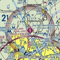
| Sectional chart |
|---|
|
CAUTION: Diagram may not be current

| Airport distance calculator |
|---|
|
|
| Sunrise and sunset |
|---|
|
Times for 16-Jun-2026
| | Local
(UTC-4) | | Zulu
(UTC) |
|---|
| Morning civil twilight | | 05:48 | | 09:48 |
| Sunrise | | 06:20 | | 10:20 |
| Sunset | | 21:08 | | 01:08 |
| Evening civil twilight | | 21:39 | | 01:39 |
|
| Current date and time |
|---|
| Zulu (UTC) | 16-Jun-2026 23:34:14 |
|---|
| Local (UTC-4) | 16-Jun-2026 19:34:14 |
|---|
|
| METAR |
|---|
| KJVY | 162315Z AUTO 20006G12KT 10SM SCT100 23/15 A2973 RMK AO2
|
KLOU
10nm S | 162253Z 22007KT 10SM BKN100 23/12 A2976 RMK AO2 SLP075 T02330117
|
KSDF
11nm S | 162256Z 21008KT 10SM -RA FEW080 BKN100 24/12 A2976 RMK AO2 RAB48 SLP074 P0000 T02390122
|
|
| TAF |
|---|
KSDF
11nm S | 161740Z 1618/1724 24010G18KT P6SM BKN060 FM162300 22008KT P6SM VCSH OVC100 PROB30 1700/1706 -SHRA OVC050 FM170600 19005KT P6SM SCT050 FM171500 20013G23KT P6SM SCT050
|
|
| NOTAMs |
|---|
NOTAMs are issued by the DoD/FAA and will open in a separate window not controlled by AirNav.
|
|


