FAA INFORMATION EFFECTIVE 14 MAY 2026
Location
| FAA Identifier: | ARR |
| Lat/Long: | 41-46-18.9000N 088-28-32.4000W
41-46.315000N 088-28.540000W
41.7719167,-88.4756667
(estimated) |
| Elevation: | 712 ft. / 217.0 m (surveyed) |
| Variation: | 01W (1990) |
| From city: | 38 miles W of central business district of the associated city |
| Time zone: | UTC -5 (UTC -6 during Standard Time) |
| Zip code: | 60554 |
Airport Operations
| Airport use: | Open to the public |
| Activation date: | 04/1966 |
| Control tower: | yes |
| ARTCC: | CHICAGO CENTER |
| FSS: | KANKAKEE FLIGHT SERVICE STATION |
| NOTAMs facility: | ARR (NOTAM-D service available) |
| Attendance: | 0600-2400 |
| Wind indicator: | lighted |
| Segmented circle: | no |
| Lights: | ACTVT MALSR RWY 09, 33; REIL RWY 18, 36,15, 27; TWY LGTS - CTAF. WHEN ATCT CLSD HIRL RWY 15/33, 09/27; MIRL RWY 18/36 PRESET LOW INTST, TO INCR INTST & ACTVT - CTAF. |
| Beacon: | white-green (lighted land airport)
Operates sunset to sunrise. |
Airport Communications
| CTAF: | 120.6 |
| ATIS: | 125.85 |
| WX ASOS: | PHONE 630-466-5649 |
| AURORA GROUND: | 121.7 [0700-2100] |
| AURORA TOWER: | 120.6 [0700-2100] |
| CHICAGO APPROACH: | 133.5 |
| CHICAGO DEPARTURE: | 133.5 |
| CLEARANCE DELIVERY: | 121.7 ;WHEN AURORA TWR CLSD |
| WX ASOS at DPA (13 nm NE): | PHONE 630-587-3668 |
| WX AWOS-3 at DKB (14 nm NW): | 119.075 (815-748-2350) |
| WX AWOS-3PT at LOT (20 nm SE): | 126.675 (815-588-4802) |
- FBO SVCS ON FREQ 122.95 AND 123.50.
- EMERG FREQ 121.5 NOT AVBL AT TWR.
Nearby radio navigation aids
| VOR radial/distance | | VOR name | | Freq | | Var |
|---|
| DPAr216/9.1 | | DUPAGE VOR/DME | | 114.55 | | 02E |
| JOTr330/15.3 | | JOLIET VOR/DME | | 112.30 | | 02E |
| OBKr223/35.7 | | NORTHBROOK VOR/DME | | 113.00 | | 02W |
Airport Services
| Fuel available: | 100 JET-A1 |
| Parking: | hangars and tiedowns |
| Airframe service: | MAJOR |
| Powerplant service: | MAJOR |
| Bottled oxygen: | HIGH/LOW |
| Bulk oxygen: | HIGH/LOW |
Runway Information
Runway 9/27
| Dimensions: | 6501 x 100 ft. / 1982 x 30 m |
| Surface: | concrete/grooved, in good condition |
| Weight bearing capacity: | | Single wheel: | 30.0 | | Double wheel: | 130.0 |
|
| Runway edge lights: | high intensity |
| RUNWAY 9 | | RUNWAY 27 |
| Latitude: | 41-46.209180N | | 41-46.225158N |
| Longitude: | 088-29.121862W | | 088-27.692040W |
| Elevation: | 706.8 ft. | | 707.2 ft. |
| Traffic pattern: | left | | left |
| Runway heading: | 090 magnetic, 089 true | | 270 magnetic, 269 true |
| Declared distances: | ASDA:6972 | | ASDA:6460 LDA:6460 |
| Markings: | precision, in good condition | | precision, in good condition |
| Visual slope indicator: | 4-light PAPI on left (3.00 degrees glide path) | | 4-light PAPI on left (3.00 degrees glide path) |
| Approach lights: | MALSR: 1,400 foot medium intensity approach lighting system with runway alignment indicator lights | | |
| Runway end identifier lights: | no | | yes |
| Touchdown point: | yes, no lights | | yes, no lights |
| Instrument approach: | ILS | | |
Runway 15/33
| Dimensions: | 5503 x 100 ft. / 1677 x 30 m |
| Surface: | concrete/grooved, in good condition |
| Weight bearing capacity: | |
| Runway edge lights: | high intensity |
| RUNWAY 15 | | RUNWAY 33 |
| Latitude: | 41-46.801653N | | 41-46.044280N |
| Longitude: | 088-29.169375W | | 088-28.504982W |
| Elevation: | 712.0 ft. | | 698.5 ft. |
| Traffic pattern: | left | | left |
| Runway heading: | 148 magnetic, 147 true | | 328 magnetic, 327 true |
| Markings: | precision, in good condition | | precision, in good condition |
| Visual slope indicator: | 4-light PAPI on left (3.00 degrees glide path) | | 4-light PAPI on left (3.00 degrees glide path) |
| Approach lights: | | | MALSR: 1,400 foot medium intensity approach lighting system with runway alignment indicator lights |
| Runway end identifier lights: | yes | | no |
| Touchdown point: | yes, no lights | | yes, no lights |
| Instrument approach: | | | LOC/DME |
Runway 18/36
| Dimensions: | 3198 x 75 ft. / 975 x 23 m |
| Surface: | asphalt, in poor condition
SEVERAL LARGE CRACKS & VEGETATIVE GROWTH. |
| Weight bearing capacity: | |
| Runway edge lights: | medium intensity |
| RUNWAY 18 | | RUNWAY 36 |
| Latitude: | 41-46.594900N | | 41-46.068287N |
| Longitude: | 088-28.296967W | | 088-28.296355W |
| Elevation: | 700.1 ft. | | 700.4 ft. |
| Traffic pattern: | left | | left |
| Runway heading: | 181 magnetic, 180 true | | 001 magnetic, 360 true |
| Markings: | basic, in fair condition | | nonprecision, in fair condition |
| Visual slope indicator: | 4-light PAPI on left (3.00 degrees glide path) | | 4-box VASI on left (3.00 degrees glide path) |
| Runway end identifier lights: | yes | | yes |
| Touchdown point: | yes, no lights | | yes, no lights |
Airport Ownership and Management from official FAA records
| Ownership: | Publicly-owned |
| Owner: | CITY OF AURORA
44 E. DOWNER PLACE
AURORA, IL 60507
Phone (630) 256-3120 |
| Manager: | STEVE ANDRAS
43W 636 US30
SUGAR GROVE, IL 60554
Phone (630) 256-3120 |
Additional Remarks
| A58-18 | RISING GROUND +6 FEET. |
| A100 | 800 FT FOR PISTON ACFT, & 1500 FTFOR FOR JET ACFT. |
| - | SEASONAL CROPS IN PART 77 SURFACES RUNWAY 9/27 & 15/33 |
Instrument Procedures
NOTE: All procedures below are presented as PDF files. If you need a reader for these files, you should download the free Adobe Reader.NOT FOR NAVIGATION. Please procure official charts for flight.
FAA instrument procedures published for use from 14 May 2026 at 0901Z to 11 June 2026 at 0900Z.
IAPs - Instrument Approach Procedures |
|---|
| ILS OR LOC RWY 09 | |
download (227KB) |
| RNAV (GPS) RWY 09 | |
download (240KB) |
| RNAV (GPS) RWY 15 | |
download (206KB) |
| RNAV (GPS) RWY 27 | |
download (206KB) |
| RNAV (GPS) RWY 33 | |
download (205KB) |
| LOC RWY 33 | |
download (266KB) |
| NOTE: Special Alternate Minimums apply | |
download (162KB) |
Departure Procedures |
|---|
| ADELL EIGHT (RNAV) | |
download (213KB) |
| BLOKR EIGHT (RNAV) | |
download (224KB) |
| CARYN EIGHT (RNAV) | |
download (202KB) |
| DARCY EIGHT (RNAV) | |
download (219KB) |
| ELANR NINE (RNAV) | |
download (223KB) |
| OBENE THREE (RNAV) | |
2 pages:
[1] [2] (410KB) |
| NOTE: Special Take-Off Minimums/Departure Procedures apply | |
download (201KB) |
Other nearby airports with instrument procedures:
KDPA - DuPage Airport (13 nm NE)
KDKB - De Kalb Taylor Municipal Airport (14 nm NW)
1C5 - Bolingbrook's Clow International Airport (16 nm E)
KLOT - Lewis University Airport (20 nm SE)
C09 - Morris Municipal Airport/James R Washburn Field (21 nm S)
|
|

Road maps at:
MapQuest
Bing
Google
| Aerial photo |
|---|
WARNING: Photo may not be current or correct
 Photo by Gina Cascella
Photo taken 29-Jul-2008
Photo by Gina Cascella
Photo taken 29-Jul-2008
Do you have a better or more recent aerial photo of Aurora Municipal Airport that you would like to share? If so, please send us your photo.
|
| Sectional chart |
|---|
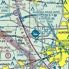
|
CAUTION: Diagram may not be current
 Download PDF
of official airport diagram from the FAA
| Airport distance calculator |
|---|
|
|
| Sunrise and sunset |
|---|
|
Times for 06-Jun-2026
| | Local
(UTC-5) | | Zulu
(UTC) |
|---|
| Morning civil twilight | | 04:47 | | 09:47 |
| Sunrise | | 05:21 | | 10:21 |
| Sunset | | 20:24 | | 01:24 |
| Evening civil twilight | | 20:58 | | 01:58 |
|
| Current date and time |
|---|
| Zulu (UTC) | 07-Jun-2026 01:23:26 |
|---|
| Local (UTC-5) | 06-Jun-2026 20:23:26 |
|---|
|
| METAR |
|---|
| KARR | 070052Z 07009KT 10SM CLR 26/17 A2986 RMK AO2 SLP104 T02610172
|
KDPA
13nm NE | 070052Z 05009KT 10SM CLR 25/15 A2987 RMK AO2 SLP109 T02500150 $
|
KDKB
14nm NW | 070055Z AUTO 08009KT 10SM SCT060 SCT075 BKN085 26/18 A2989 RMK AO2 T02570179
|
KLOT
19nm SE | 070045Z 05010KT 10SM FEW055 26/17 A2987
|
|
| TAF |
|---|
KDPA
13nm NE | 062100Z 0621/0718 07009KT P6SM SCT040 PROB30 0621/0624 5SM -SHRA BKN040 FM070100 07005KT P6SM FEW015 BKN050
|
|
| NOTAMs |
|---|
NOTAMs are issued by the DoD/FAA and will open in a separate window not controlled by AirNav.
|
|


