FAA INFORMATION EFFECTIVE 19 MARCH 2026
Location
| FAA Identifier: | IAH |
| Lat/Long: | 29-59-03.9670N 095-20-29.1930W
29-59.066117N 095-20.486550W
29.9844353,-95.3414425
(estimated) |
| Elevation: | 95.8 ft. / 29.2 m (surveyed) |
| Variation: | 03E (2015) |
| From city: | 15 miles N of HOUSTON, TX |
| Time zone: | UTC -5 (UTC -6 during Standard Time) |
| Zip code: | 77396 |
Airport Operations
| Airport use: | Open to the public |
| Activation date: | 01/1963 |
| Control tower: | yes |
| ARTCC: | HOUSTON CENTER |
| FSS: | MONTGOMERY COUNTY FLIGHT SERVICE STATION |
| NOTAMs facility: | IAH (NOTAM-D service available) |
| Attendance: | CONTINUOUS |
| Wind indicator: | lighted |
| Segmented circle: | no |
| Lights: | SS-SR |
| Beacon: | white-green (lighted land airport)
Operates sunset to sunrise. |
| Fire and rescue: | ARFF index E |
| International operations: | customs landing rights airport |
Airport Communications
| UNICOM: | 122.95 |
| WX ASOS: | PHONE 713-338-9561 |
| HOUSTON GROUND: | 118.575 ;RWY 08L/26R, 08R/26L, 09/27 119.95 121.7 ;RWY 15L/33R, 15R/33L |
| HOUSTON TOWER: | 120.725 ;RWY 08L/26R 125.35 ;RWY 08R/26L 127.3 ;RWY 15L/33R, 15R/33L 135.15 ;RWY 09/27 288.25 ;RWY 15L/33R, 15R/33L 290.2 ;RWY 08L/26R, 08R/26L, 09/27 |
| HOUSTON APPROACH: | 120.05 ;EAST 124.35 ;WEST |
| HOUSTON DEPARTURE: | 119.7 ;NORTH 123.8 ;WEST 127.125 |
| CLEARANCE DELIVERY: | 128.1 |
| ALEXANDRIA DP: | 132.25 |
| BAZBL RNAV STAR: | 134.3 |
| BLTWY RNAV DP: | 132.25 |
| BNDTO DP: | 126.675 |
| CLASS B: | 127.125 ;EAST |
| CRIED DP: | 132.25 |
| D-ATIS: | 124.05 |
| DOOBI STAR: | 120.05 |
| DRLLR STAR: | 124.35 |
| DUUUK STAR: | 119.175 |
| EL DORADO DP: | 132.25 |
| EMERG: | 121.5 |
| FLYZA RNAV DP: | 127.125 |
| GESNR STAR: | 120.05 |
| GIFFA DP: | 132.25 |
| GILCO STAR: | 119.625 |
| GUMBY DP: | 127.125 |
| GUSHR STAR: | 124.35 |
| HOODO RNAV DP: | 127.125 |
| HTOWN STAR: | 119.175 |
| HUDZY STAR: | 120.05 |
| IC: | 120.05 ;EAST 124.35 ;WEST |
| INDIE DP: | 132.25 |
| JUNCTION DP: | 126.675 |
| LAKE CHARLES DP: | 127.125 |
| LEONA DP: | 132.25 |
| LINKK STAR: | 119.625 |
| LUFKIN DP: | 132.25 |
| LURIC RNAV DP: | 132.25 |
| METERING: | 119.95 |
| MMUGS RNAV DP: | 127.125 |
| MSCOT STAR: | 124.35 |
| NNCEE STAR: | 119.625 |
| OHIIO STAR: | 120.05 |
| PITZZ RNAV DP: | 126.675 |
| RIICE STAR: | 124.35 |
| RITAA RNAV DP: | 127.125 |
| SKNRD STAR: | 120.05 |
| SOULL STAR: | 119.625 |
| STRYA RNAV DP: | 132.25 |
| STYCK RNAV DP: | 132.25 |
| TEJAS STAR: | 119.175 |
| TRUAX DP: | 127.125 |
| TTORO STAR: | 124.35 |
| WYLSN RNAV DP: | 132.25 |
| ZEEKK STAR: | 120.05 |
| WX ASOS at DWH (12 nm NW): | 128.375 (281-251-7853) |
- ACFT EQUIPPED WITH DUAL ANTENNAS SHOULD USE TOP ANTENNA.
- ASDE-X IN USE. OPERATE TRANSPONDERS WITH ALTITUDE REPORTING MODE AND ADS-B (IF EQUIPPED) ENABLED ON ALL AIRPORT SURFACES.
Nearby radio navigation aids
| VOR radial/distance | | VOR name | | Freq | | Var |
|---|
| IAHr003/1.7 | | HUMBLE VORTAC | | 116.60 | | 05E |
| DASr246/38.2 | | DAISETTA VORTAC | | 116.90 | | 05E |
Airport Services
| Fuel available: | 100LL JET-A |
| Parking: | hangars and tiedowns |
| Airframe service: | MAJOR |
| Powerplant service: | MAJOR |
| Bottled oxygen: | NONE |
| Bulk oxygen: | LOW |
Runway Information
Runway 15L/33R
| Dimensions: | 12001 x 150 ft. / 3658 x 46 m |
| Surface: | concrete/grooved, in good condition |
| Weight bearing capacity: | | Single wheel: | 100.0 | | Double wheel: | 200.0 | | Double tandem: | 400.0 | | Dual double tandem: | 800.0 |
|
| Runway edge lights: | high intensity |
| RUNWAY 15L | | RUNWAY 33R |
| Latitude: | 29-59.273377N | | 29-57.525842N |
| Longitude: | 095-21.472225W | | 095-20.403150W |
| Elevation: | 94.6 ft. | | 84.9 ft. |
| Traffic pattern: | left | | left |
| Runway heading: | 149 magnetic, 152 true | | 329 magnetic, 332 true |
| Declared distances: | TORA:12001 TODA:12001 ASDA:12001 LDA:12001 | | TORA:12001 TODA:12001 ASDA:12001 LDA:12001 |
| Markings: | nonprecision, in good condition | | precision, in good condition |
| Visual slope indicator: | 4-light PAPI on right (3.00 degrees glide path) | | |
| RVR equipment: | touchdown, midfield, rollout | | touchdown, midfield, rollout |
| Approach lights: | | | MALSR: 1,400 foot medium intensity approach lighting system with runway alignment indicator lights |
| Centerline lights: | yes | | yes |
| Touchdown point: | yes, no lights | | yes, no lights |
| Instrument approach: | | | ILS |
Runway 9/27
| Dimensions: | 10000 x 150 ft. / 3048 x 46 m |
| Surface: | concrete/grooved, in good condition |
| Weight bearing capacity: | | Double wheel: | 210.0 | | Double tandem: | 560.0 |
|
| Runway edge lights: | high intensity |
| RUNWAY 9 | | RUNWAY 27 |
| Latitude: | 29-58.655605N | | 29-58.656785N |
| Longitude: | 095-20.046485W | | 095-18.151580W |
| Elevation: | 89.9 ft. | | 84.3 ft. |
| Traffic pattern: | left | | left |
| Runway heading: | 087 magnetic, 090 true | | 267 magnetic, 270 true |
| Declared distances: | TORA:10000 TODA:10000 ASDA:10000 LDA:10000 | | TORA:10000 TODA:10000 ASDA:10000 LDA:10000 |
| Markings: | precision, in good condition | | precision, in good condition |
| Visual slope indicator: | 4-light PAPI on right (3.00 degrees glide path) | | 4-light PAPI on left (3.00 degrees glide path) |
| RVR equipment: | touchdown, midfield, rollout | | touchdown, midfield, rollout |
| Approach lights: | MALSR: 1,400 foot medium intensity approach lighting system with runway alignment indicator lights | | ALSF2: standard 2,400 foot high intensity approach lighting system with centerline sequenced flashers (category II or III) |
| Centerline lights: | yes | | yes |
| Touchdown point: | yes, no lights | | yes, lighted |
| Instrument approach: | ILS/DME | | ILS/DME |
Runway 15R/33L
| Dimensions: | 10000 x 150 ft. / 3048 x 46 m |
| Surface: | concrete/grooved, in good condition |
| Weight bearing capacity: | | Single wheel: | 75.0 | | Double wheel: | 200.0 | | Double tandem: | 400.0 | | Dual double tandem: | 873.0 |
|
| Runway edge lights: | high intensity |
| RUNWAY 15R | | RUNWAY 33L |
| Latitude: | 29-59.268470N | | 29-57.812457N |
| Longitude: | 095-21.683973W | | 095-20.793018W |
| Elevation: | 94.8 ft. | | 86.5 ft. |
| Traffic pattern: | left | | left |
| Runway heading: | 149 magnetic, 152 true | | 329 magnetic, 332 true |
| Declared distances: | TORA:10000 TODA:10000 ASDA:10000 LDA:10000 | | TORA:10000 TODA:10000 ASDA:10000 LDA:10000 |
| Markings: | precision, in good condition | | nonprecision, in good condition |
| Visual slope indicator: | 4-light PAPI on left (3.00 degrees glide path) | | 4-light PAPI on right (3.00 degrees glide path) |
| RVR equipment: | touchdown, midfield, rollout | | touchdown, midfield, rollout |
| Approach lights: | MALSR: 1,400 foot medium intensity approach lighting system with runway alignment indicator lights | | |
| Centerline lights: | yes | | yes |
| Touchdown point: | yes, lighted | | yes, lighted |
| Instrument approach: | LOC/GS | | |
Runway 8R/26L
| Dimensions: | 9402 x 150 ft. / 2866 x 46 m |
| Surface: | concrete/grooved, in good condition |
| Weight bearing capacity: | | Single wheel: | 75.0 | | Double wheel: | 210.0 | | Double tandem: | 498.0 | | Dual double tandem: | 873.0 |
|
| Runway edge lights: | high intensity |
| RUNWAY 8R | | RUNWAY 26L |
| Latitude: | 29-59.605047N | | 29-59.606362N |
| Longitude: | 095-21.297838W | | 095-19.515898W |
| Elevation: | 94.3 ft. | | 92.3 ft. |
| Traffic pattern: | left | | left |
| Runway heading: | 087 magnetic, 090 true | | 267 magnetic, 270 true |
| Declared distances: | TORA:9402 TODA:9402 ASDA:9402 LDA:9402 | | TORA:9402 TODA:9402 ASDA:9402 LDA:9402 |
| Markings: | precision, in good condition | | precision, in good condition |
| Visual slope indicator: | 4-light PAPI on left (3.00 degrees glide path) | | 4-light PAPI on right (3.00 degrees glide path) |
| RVR equipment: | touchdown, midfield, rollout | | touchdown, midfield, rollout |
| Approach lights: | MALSR: 1,400 foot medium intensity approach lighting system with runway alignment indicator lights | | ALSF2: standard 2,400 foot high intensity approach lighting system with centerline sequenced flashers (category II or III) |
| Centerline lights: | yes | | yes |
| Touchdown point: | yes, lighted | | yes, lighted |
| Instrument approach: | ILS/DME | | ILS/DME |
Runway 8L/26R
| Dimensions: | 9000 x 150 ft. / 2743 x 46 m |
| Surface: | concrete/grooved, in excellent condition |
| Weight bearing capacity: | | Single wheel: | 75.0 | | Double wheel: | 210.0 | | Double tandem: | 409.0 | | Dual double tandem: | 873.0 |
|
| Runway edge lights: | high intensity |
| RUNWAY 8L | | RUNWAY 26R |
| Latitude: | 30-00.429693N | | 30-00.431020N |
| Longitude: | 095-21.527455W | | 095-19.821485W |
| Elevation: | 90.6 ft. | | 94.2 ft. |
| Traffic pattern: | left | | left |
| Runway heading: | 087 magnetic, 090 true | | 267 magnetic, 270 true |
| Declared distances: | TORA:9000 TODA:9000 ASDA:9000 LDA:9000 | | TORA:9000 TODA:9000 ASDA:9000 LDA:9000 |
| Markings: | precision, in good condition | | precision, in good condition |
| RVR equipment: | touchdown, midfield, rollout | | touchdown, midfield, rollout |
| Approach lights: | ALSF2: standard 2,400 foot high intensity approach lighting system with centerline sequenced flashers (category II or III) | | ALSF2: standard 2,400 foot high intensity approach lighting system with centerline sequenced flashers (category II or III) |
| Centerline lights: | yes | | yes |
| Touchdown point: | yes, lighted | | yes, lighted |
| Instrument approach: | ILS/DME | | ILS/DME |
Airport Ownership and Management from official FAA records
| Ownership: | Publicly-owned |
| Owner: | CITY OF HOUSTON
PO BOX 60106
HOUSTON, TX 77205
Phone 281-233-1131
DEPT OF AVIATION, ADMIN OFFICE. |
| Manager: | STEVEN RUNGE
PO BOX 60106
HOUSTON, TX 77205
Phone 281-233-1131 |
Additional Remarks
| A39-15L/33R | PCR VALUE: 870/R/B/W/T |
| A39-08L/26R | PCR VALUE: 1100/R/A/W/T |
| A39-09/27 | PCR VALUE: 690/R/A/W/T |
| A39-15R/33L | PCR VALUE: 980/R/A/W/T |
| A39-08R/26L | PCR VALUE: 1090/R/A/W/T |
| - | TWY 'NR' CLSD TO ACFT WITH WING SPANS GREATER THAN 125 FT BTN TWY 'WD' & TWY 'WB'. |
| - | TWY 'SF' BTN TWY 'NB' AND TXL 'RA' IS DSGND NON-MOV AREA. |
| - | DUAL TWY OPNS TWY NK BTN TWY NB & NORTH RAMP; WEST CNTRLN RSTRD TO ACFT MAX WING SPANS 125 FT & EAST CNTRLN MAX WING SPANS 214 FT. |
| - | BIRDS ON & INVOF ARPT. |
| - | THE FLWG MOV AREAS ARE NOT VSB FM THE ATCT: PORTIONS OF TWYS 'WA' & 'WB' FM TWY 'WH' TO THE AER 33R; TWYS 'WA' & 'WB' FM TWY 'WD' NORTH FOR 400 FT; TWY 'WD' FM TWY 'WA' TO TWY 'NR'; TWY 'NR'; TWY 'WL' FM RWY 15L TO TWY 'WB' & TWY 'WM'. |
| - | TXLN 'RA', 'RB', 'RC', 'R2', AND TWY 'SC' NORTH OF TWY 'SB' ARE DSGND NON-MOVEMENT AREAS OPERD BY UAL RAMP CTL. |
| - | RWY 15L/33R MAGNETIC ANOMALIES MAY AFFECT COMPASS HDG FOR TKOF. |
| - | TWYS WA & WB MAGNETIC ANOMALIES MAY AFFECT COMPASS HDG. |
| - | APRON TERMINAL ALPHA NORTH RAMP NORTH-SOUTH TXL CLSD TO ACFT WINGSPAN MORE THAN 125 FT. |
| - | TWY WC WEST OF RWY 15R/33L RSTRD TO ACFT WITH 118 FT WING SPAN AND BLW. |
| - | NOISE SENSITIVE AREA N, E AND W OF ARPT. |
| - | RWY STATUS LGTS ARE IN OPN. |
| - | TWY WW RUN UP PAD FOR RWY 15L CLSD TO ACFT WITH WINGSPAN 135 FT & OVER. |
| - | RWY 09/27 CLSD TO ACFT WITH WINGSPAN 215 FT & ABOVE. |
| - | TWY SF BTN RWY 09/27 UP TO AND INCLUDING THE EAST BRIDGE CLSD TO ACFT WITH WINGSPAN 215 FT & OVER. |
| - | TWY NR BTN TWY NC AND TWY WW CLSD TO ACFT WINGSPAN MORE THAN 214 FT. |
| - | TWY WW BTN TWY NR AND TWY WB CLSD TO ACFT WINGSPAN MORE THAN 214 FT. |
| - | TWY NR BTN WW AND TWY WB DSGND NON-MOVEMENT AREA. |
| - | TWY NK BTN TWY NB AND TERMINAL D RAMP SIMULTANEOUS ACFT OPS PROHIBITED WHEN MIDDLE TAXILANE IN USE. |
| - | HEL HOVER/TAXI RSTRD TO HARD SFC MOV AREAS ONLY. |
| - | 9 FT AGL UNMKD SECURITY FENCE ADJ TO FBO & CORPORATE BASE OPR RAMPS AND NONMOV AREA TXLS. |
| - | GBAS APCH SVC VOL 20NM FR THR, ALL GLS APCHS. |
| - | TWY NA LGT ALL BTN TWY WP AND TWY NP NOT STD |
| - | PILOTS & CREWS SHOULD BE AWARE OF DEP TURNS ON CRS IN EXCESS OF 180 DEGS. PILOT READ BACK OF DRCTN OF TURN IS HIGHLY ENCOURAGED. |
| - | WILDLIFE HAZ BATS INVOF IAH. |
| - | APRON TERMINAL ALPHA NORTH RAMP SPOT 5 CLSD TO ACFT WINGSPAN MORE THAN 118 FT. |
| - | APRON TERMINAL ALPHA NORTH RAMP EAST-WEST TXL CLSD TO ACFT WINGSPAN MORE THAN 118 FT. |
| - | APRON TERMINAL ALPHA NORTH RAMP SPOT 6 CLSD TO ACFT WINGSPAN MORE THAN 125 FT. |
| - | TWY WD BTN TWY NR AND TWY WB CLSD TO ACFT WINGSPAN MORE THAN 171 FT. |
| - | TWY NJ BTN TWY NB AND TERMINAL C RAMP SIMULTANEOUS ACFT OPS PROHIBITED WHEN MIDDLE TAXILANE IN USE, MIDDLE TAXILANE CLSD TO ACFT WINGSPAN MORE THAN 214FT. |
| - | DUAL TWY OPNS TWY NJ BTN TWY NB & TERMINAL C RAMP; WEST CNTRLN RSTRD TO ACFT MAX WING SPANS 118 FT & EAST CNTRLN MAX WING SPANS 118 FT. |
| - | TWY RC CLSD TO ACFT WITH WINGSPAN GTR THAN 118 FT. |
Instrument Procedures
NOTE: All procedures below are presented as PDF files. If you need a reader for these files, you should download the free Adobe Reader.NOT FOR NAVIGATION. Please procure official charts for flight.
FAA instrument procedures published for use from 19 March 2026 at 0901Z to 16 April 2026 at 0900Z.
STARs - Standard Terminal Arrivals |
|---|
| BAZBL ONE (RNAV) | |
download (255KB) |
| DOOBI THREE (RNAV) | |
download (244KB) |
| DRLLR FIVE (RNAV) | |
2 pages:
[1] [2] (535KB) |
| DUUUK FOUR | |
download (225KB) |
| GESNR TWO (RNAV) | |
2 pages:
[1] [2] (414KB) |
| GILCO FIVE | |
2 pages:
[1] [2] (416KB) |
| GUSHR THREE (RNAV) | |
download (266KB) |
| HTOWN THREE (RNAV) | |
download (230KB) |
| HUDZY FIVE | |
2 pages:
[1] [2] (283KB) |
| LINKK ONE (RNAV) | |
2 pages:
[1] [2] (468KB) |
| MSCOT FOUR (RNAV) | |
download (328KB) |
| NNCEE TWO (RNAV) | |
2 pages:
[1] [2] (522KB) |
| OHIIO FOUR | |
download (266KB) |
| RIICE ONE | |
2 pages:
[1] [2] (506KB) |
| SKNRD FIVE (RNAV) | |
2 pages:
[1] [2] (388KB) |
| SOULL ONE (RNAV) | |
2 pages:
[1] [2] (449KB) |
| TEJAS FIVE (RNAV) | |
2 pages:
[1] [2] (537KB) |
| TTORO THREE (RNAV) | |
download (220KB) |
| ZEEKK THREE (RNAV) | |
2 pages:
[1] [2] (366KB) |
IAPs - Instrument Approach Procedures |
|---|
| ILS OR LOC RWY 08L | |
download (263KB) |
| ILS OR LOC RWY 08R | |
download (291KB) |
| ILS OR LOC RWY 09 | |
download (292KB) |
| ILS OR LOC RWY 15R | |
download (261KB) |
| ILS OR LOC RWY 26L | |
download (338KB) |
| ILS OR LOC RWY 26R | |
download (316KB) |
| ILS OR LOC RWY 27 | |
download (366KB) |
| ILS OR LOC RWY 33R | |
download (259KB) |
| ILS RWY 08L (SA CAT I) | |
download (260KB) |
| ILS RWY 26L (SA CAT I) | |
download (323KB) |
| ILS RWY 26R (SA CAT I) | |
download (298KB) |
| ILS RWY 27 (SA CAT I) | |
download (362KB) |
| ILS RWY 08R (SA CAT I - II) | |
download (299KB) |
| ILS RWY 09 (SA CAT I - II) | |
download (304KB) |
| ILS RWY 08L (CAT II - III) | |
download (268KB) |
| ILS RWY 26L (CAT II - III) | |
download (327KB) |
| ILS RWY 26R (CAT II - III) | |
download (314KB) |
| ILS RWY 27 (CAT II - III) | |
download (368KB) |
| GLS RWY 08L | |
download (208KB) |
| GLS RWY 08R | |
download (223KB) |
| GLS RWY 09 | |
download (219KB) |
| GLS RWY 26L | |
download (222KB) |
| GLS RWY 26R | |
download (220KB) |
| GLS RWY 27 | |
download (254KB) |
| RNAV (RNP) Y RWY 08L | |
download (234KB) |
| RNAV (RNP) Y RWY 08R | |
download (249KB) |
| RNAV (RNP) Y RWY 09 | |
download (236KB) |
| RNAV (RNP) Y RWY 26L | |
download (247KB) |
| RNAV (RNP) Y RWY 26R | |
download (276KB) |
| RNAV (RNP) Y RWY 27 | |
download (292KB) |
| RNAV (GPS) RWY 15R | |
download (229KB) |
| RNAV (GPS) RWY 33R | |
download (238KB) |
| RNAV (GPS) Z RWY 08L | |
download (251KB) |
| RNAV (GPS) Z RWY 08R | |
download (273KB) |
| RNAV (GPS) Z RWY 09 | |
download (266KB) |
| RNAV (GPS) Z RWY 26L | |
download (261KB) |
| RNAV (GPS) Z RWY 26R | |
download (257KB) |
| RNAV (GPS) Z RWY 27 | |
download (300KB) |
Departure Procedures |
|---|
| ALEXANDRIA THREE | |
2 pages:
[1] [2] (322KB) |
| BLTWY SEVEN (RNAV) | |
download (208KB) |
| BNDTO SIX (RNAV) | |
2 pages:
[1] [2] (353KB) |
| CRIED ONE | |
download (169KB) |
| EL DORADO ONE **CHANGED** | |
download (184KB) |
| FLYZA FIVE (RNAV) | |
2 pages:
[1] [2] (303KB) |
| GIFFA ONE | |
download (169KB) |
| GUMBY THREE (RNAV) | |
2 pages:
[1] [2] (309KB) |
| HOODO SEVEN (RNAV) | |
2 pages:
[1] [2] (316KB) |
| INDIE EIGHT (RNAV) | |
download (237KB) |
| JUNCTION ONE | |
download (176KB) |
| LAKE CHARLES FIVE | |
download (177KB) |
| LEONA FOUR | |
2 pages:
[1] [2] (345KB) |
| LUFKIN FOUR | |
2 pages:
[1] [2] (256KB) |
| LURIC EIGHT (RNAV) | |
download (257KB) |
| MMUGS FOUR (RNAV) | |
2 pages:
[1] [2] (349KB) |
| PITZZ FIVE (RNAV) | |
2 pages:
[1] [2] (326KB) |
| RITAA SEVEN (RNAV) | |
2 pages:
[1] [2] (349KB) |
| STRYA EIGHT (RNAV) | |
download (245KB) |
| STYCK EIGHT (RNAV) | |
download (233KB) |
| WYLSN EIGHT (RNAV) | |
download (220KB) |
| NOTE: Special Take-Off Minimums/Departure Procedures apply | |
download (221KB) |
Other nearby airports with instrument procedures:
KDWH - David Wayne Hooks Memorial Airport (12 nm NW)
KIWS - West Houston Airport (20 nm SW)
KHOU - William P Hobby Airport (21 nm S)
KCXO - Conroe/North Houston Regional Airport (22 nm N)
KHPY - Baytown Airport (23 nm SE)
|
|

Road maps at:
MapQuest
Bing
Google
| Aerial photo |
|---|
WARNING: Photo may not be current or correct
 Photo by Brian Mensing
Photo taken 27-Mar-2020
looking east.
Photo by Brian Mensing
Photo taken 27-Mar-2020
looking east.
Do you have a better or more recent aerial photo of George Bush Intercontinental/Houston Airport that you would like to share? If so, please send us your photo.
|
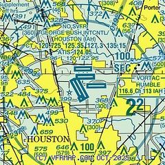
| Sectional chart |
|---|
|
CAUTION: Diagram may not be current
 Download PDF
of official airport diagram from the FAA
| Airport distance calculator |
|---|
|
|
| Sunrise and sunset |
|---|
|
Times for 20-Mar-2026
| | Local
(UTC-5) | | Zulu
(UTC) |
|---|
| Morning civil twilight | | 07:02 | | 12:02 |
| Sunrise | | 07:26 | | 12:26 |
| Sunset | | 19:32 | | 00:32 |
| Evening civil twilight | | 19:55 | | 00:55 |
|
| Current date and time |
|---|
| Zulu (UTC) | 20-Mar-2026 08:42:51 |
|---|
| Local (UTC-5) | 20-Mar-2026 03:42:51 |
|---|
|
| METAR |
|---|
KIAH
2nm NW | 200753Z 18004KT 10SM CLR 17/14 A3014 RMK AO2 SLP206 T01670144
|
KDWH
12nm NW | 200753Z AUTO 00000KT 10SM CLR 13/13 A3014 RMK AO2 SLP206 T01280128
|
|
| TAF |
|---|
KIAH
2nm NW | 200520Z 2006/2112 19005KT P6SM FEW015 TEMPO 2010/2013 5SM BR FM201500 21007KT P6SM SCT020 FM201800 20011KT P6SM FEW050 FM210000 17009KT P6SM SKC FM211000 20004KT 5SM BR SCT010
|
|
| NOTAMs |
|---|
NOTAMs are issued by the DoD/FAA and will open in a separate window not controlled by AirNav.
|
|


