FAA INFORMATION EFFECTIVE 19 MARCH 2026
Location
| FAA Identifier: | LNR |
| Lat/Long: | 43-12-42.7000N 090-10-47.4000W
43-12.711667N 090-10.790000W
43.2118611,-90.1798333
(estimated) |
| Elevation: | 717.3 ft. / 218.6 m (surveyed) |
| Variation: | 00E (1990) |
| From city: | 2 miles N of LONE ROCK, WI |
| Time zone: | UTC -5 (UTC -6 during Standard Time) |
| Zip code: | 53588 |
Airport Operations
| Airport use: | Open to the public |
| Activation date: | 11/1943 |
| Control tower: | no |
| ARTCC: | CHICAGO CENTER |
| FSS: | GREEN BAY FLIGHT SERVICE STATION |
| NOTAMs facility: | LNR (NOTAM-D service available) |
| Attendance: | MON-FRI 0800-1700 |
| Wind indicator: | yes |
| Segmented circle: | yes |
| Lights: | MIRL RWY 09/27 PRESET TO LOW SS-SR; TO INCR INTST & ACTVT REIL 09 & 27; MIRL RWY 09/27; MIRL RWY 18/36 - CTAF. PAPI RWY 09 & 27 OPR CONSLY. |
| Beacon: | white-green (lighted land airport)
Operates sunset to sunrise. |
Airport Communications
| CTAF/UNICOM: | 123.0 |
| WX ASOS: | 119.425 (608-583-2576) |
| MADISON APPROACH: | 135.45 |
| MADISON DEPARTURE: | 135.45 |
| WX AWOS-3 at MRJ (20 nm S): | 118.525 (608-987-2157) |
- APCH/DEP SVC PRVDD BY CHICAGO ARTCC ON FREQS 133.3/257.925 (LONE ROCK RCAG) WHEN MADISON APCH CTL CLSD.
Nearby radio navigation aids
| VOR radial/distance | | VOR name | | Freq | | Var |
|---|
| DLLr219/27.3 | | DELLS VORTAC | | 117.00 | | 03E |
| MSNr273/37.0 | | MADISON VORTAC | | 108.60 | | 03E |
Airport Services
| Fuel available: | 100LL JET-A+
100LL:SELF SVC FUEL AVBL H24 VIA CREDIT CARD. |
| Parking: | tiedowns |
| Airframe service: | MAJOR |
| Powerplant service: | MINOR |
| Bottled oxygen: | NONE |
| Bulk oxygen: | NONE |
Runway Information
Runway 9/27
| Dimensions: | 5000 x 75 ft. / 1524 x 23 m |
| Surface: | asphalt, in excellent condition |
| Weight bearing capacity: | |
| Runway edge lights: | medium intensity |
| RUNWAY 9 | | RUNWAY 27 |
| Latitude: | 43-12.755065N | | 43-12.760740N |
| Longitude: | 090-11.230120W | | 090-10.104785W |
| Elevation: | 714.5 ft. | | 716.7 ft. |
| Traffic pattern: | left | | left |
| Runway heading: | 089 | | 269 |
| Markings: | nonprecision, in good condition | | nonprecision, in good condition |
| Visual slope indicator: | 2-light PAPI on left (3.00 degrees glide path)
OPERS CONSLY. | | 2-light PAPI on left (4.00 degrees glide path)
OPERS CONSLY. |
| Runway end identifier lights: | yes | | yes |
| Touchdown point: | yes, no lights | | yes, no lights |
| Instrument approach: | | | LOC/DME |
| Obstructions: | 34 ft. ant, 1070 ft. from runway, 265 ft. left of centerline, 25:1 slope to clear | | 300 ft. trees, 7275 ft. from runway, 1260 ft. right of centerline, 23:1 slope to clear |
Runway 18/36
| Dimensions: | 1850 x 60 ft. / 564 x 18 m |
| Surface: | asphalt, in good condition |
| Weight bearing capacity: | |
| Runway edge lights: | medium intensity |
| RUNWAY 18 | | RUNWAY 36 |
| Latitude: | 43-12.739153N | | 43-12.434612N |
| Longitude: | 090-11.120877W | | 090-11.124095W |
| Elevation: | 714.6 ft. | | 715.9 ft. |
| Traffic pattern: | left | | left |
| Runway heading: | 180 | | 360 |
| Markings: | basic, in good condition | | basic, in good condition |
| Touchdown point: | yes, no lights | | yes, no lights |
| Obstructions: | 375 ft. trees, marked and lighted, 5000 ft. from runway, 530 ft. right of centerline, 12:1 slope to clear | | 15 ft. road, marked and lighted, 380 ft. from runway, 12:1 slope to clear |
Airport Ownership and Management from official FAA records
| Ownership: | Publicly-owned |
| Owner: | SAUK & RICHLAND COUNTIES
181 W SEMINARY ST
RICHLAND CENTER, WI 53581
Phone 608-649-3001 |
| Manager: | MARK HIGGS
E2525 CO. HWY JJ
SPRING GREEN, WI 53588
Phone 608-583-2600
EMAIL ADDRESS: MARKHIGGSTCA@YAHOO.COM (ALL LOWER CASE) |
Additional Remarks
| - | FOR CD CTC MADISON APP/DEP CON AT 608-249-8240. WHEN MADISON APCH CLSD, FOR CD CTC CHICAGO ARTCC AT 630-906-8921. |
| - | COLD TEMPERATURE AIRPORT. ALTITUDE CORRECTION REQUIRED AT OR BELOW -31C. |
Instrument Procedures
NOTE: All procedures below are presented as PDF files. If you need a reader for these files, you should download the free Adobe Reader.NOT FOR NAVIGATION. Please procure official charts for flight.
FAA instrument procedures published for use from 19 March 2026 at 0901Z to 16 April 2026 at 0900Z.
IAPs - Instrument Approach Procedures |
|---|
| RNAV (GPS) RWY 09 | |
download (273KB) |
| RNAV (GPS) RWY 27 | |
download (278KB) |
| LOC RWY 27 | |
download (283KB) |
| NOTE: Special Alternate Minimums apply | |
download (145KB) |
| NOTE: Special Take-Off Minimums/Departure Procedures apply | |
download (201KB) |
Other nearby airports with instrument procedures:
93C - Richland Airport (7 nm NW)
91C - Sauk/Prairie Airport (19 nm E)
KMRJ - Iowa County Airport (20 nm S)
C35 - Reedsburg Municipal Airport (21 nm NE)
KOVS - Boscobel Airport (22 nm W)
|
|

Road maps at:
MapQuest
Bing
Google
| Aerial photo |
|---|
WARNING: Photo may not be current or correct
 Photo by Mathieu Labs
Photo taken 20-Oct-2007
Photo by Mathieu Labs
Photo taken 20-Oct-2007
Do you have a better or more recent aerial photo of Tri-County Regional Airport that you would like to share? If so, please send us your photo.
|
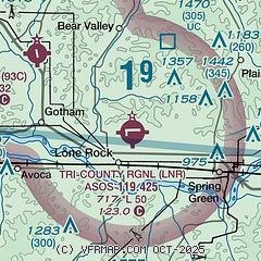
| Sectional chart |
|---|
|
| Airport distance calculator |
|---|
|
|
| Sunrise and sunset |
|---|
|
Times for 27-Mar-2026
| | Local
(UTC-5) | | Zulu
(UTC) |
|---|
| Morning civil twilight | | 06:24 | | 11:24 |
| Sunrise | | 06:52 | | 11:52 |
| Sunset | | 19:20 | | 00:20 |
| Evening civil twilight | | 19:48 | | 00:48 |
|
| Current date and time |
|---|
| Zulu (UTC) | 28-Mar-2026 00:24:05 |
|---|
| Local (UTC-5) | 27-Mar-2026 19:24:05 |
|---|
|
| METAR |
|---|
| KLNR | 272356Z AUTO 30015G26KT 10SM FEW070 03/M11 A3048 RMK AO2 PK WND 31026/2324 SLP327 T00331111 10072 20033 53022
|
|
| TAF |
|---|
KMSN
37nm E | 272219Z 2722/2818 30011G21KT P6SM SCT060 FM280100 32009KT P6SM SCT250 FM280500 VRB03KT P6SM SKC FM281600 21010KT P6SM FEW250
|
KVOK
42nm N | 270900Z 2709/2815 03006KT 9999 SKC 530109 QNH3032INS BECMG 2717/2718 29010G25KT 9999 SCT035 OVC050 530009 530901 QNH3043INS TEMPO 2718/2720 9000 -SN 620503 BECMG 2803/2804 31009KT 9999 SKC 530109 QNH3056INS TX02/2721Z TNM04/2711Z
|
|
| NOTAMs |
|---|
NOTAMs are issued by the DoD/FAA and will open in a separate window not controlled by AirNav.
|
|

