FAA INFORMATION EFFECTIVE 04 SEPTEMBER 2025
Location
| FAA Identifier: | XSA |
| Lat/Long: | 37-51-34.5930N 076-53-38.8300W
37-51.576550N 076-53.647167W
37.8596092,-76.8941194
(estimated) |
| Elevation: | 135.2 ft. / 41.2 m (surveyed) |
| Variation: | 11W (2010) |
| From city: | 5 miles S of TAPPAHANNOCK, VA |
| Time zone: | UTC -4 (UTC -5 during Standard Time) |
| Zip code: | 22454 |
Airport Operations
| Airport use: | Open to the public |
| Activation date: | 08/2007 |
| Control tower: | no |
| ARTCC: | WASHINGTON CENTER |
| FSS: | LEESBURG FLIGHT SERVICE STATION |
| NOTAMs facility: | XSA (NOTAM-D service available) |
| Attendance: | NOV - FEB 0800-1800, MAR - OCT 0900-1900 |
| Wind indicator: | lighted |
| Segmented circle: | no |
| Lights: | ACTVT PAPI RWY 10 & 28; MIRL RWY 10/28 - CTAF. |
| Beacon: | white-green (lighted land airport)
ACTVT ROTG BCN - CTAF. |
Airport Communications
| CTAF/UNICOM: | 122.8 |
| WX AWOS-3: | 125.775 (804-445-8724) |
| POTOMAC APPROACH: | 126.4 |
| POTOMAC DEPARTURE: | 126.4 |
Nearby radio navigation aids
| VOR radial/distance | | VOR name | | Freq | | Var |
|---|
| HCMr348/26.1 | | HARCUM VORTAC | | 108.80 | | 07W |
| RICr052/29.5 | | RICHMOND VORTAC | | 114.10 | | 09W |
| HPWr024/33.5 | | HOPEWELL VORTAC | | 114.35 | | 06W |
| BRVr152/35.9 | | BROOKE VORTAC | | 114.50 | | 09W |
| NDB name | | Hdg/Dist | | Freq | | Var | | ID |
|---|
| PATUXENT | | 232/34.5 | | 400 | | 10W | | NHK | -. .... -.- |
| SHANNON | | 143/35.9 | | 237 | | 10W | | EZF | . --.. ..-. |
Airport Services
| Fuel available: | 100LL JET-A |
| Parking: | hangars and tiedowns |
| Airframe service: | MAJOR |
| Powerplant service: | MAJOR |
Runway Information
Runway 10/28
| Dimensions: | 4300 x 75 ft. / 1311 x 23 m |
| Surface: | asphalt, in good condition |
| Weight bearing capacity: | |
| Runway edge lights: | medium intensity |
| RUNWAY 10 | | RUNWAY 28 |
| Latitude: | 37-51.549600N | | 37-51.603488N |
| Longitude: | 076-54.092648W | | 076-53.201673W |
| Elevation: | 135.2 ft. | | 127.7 ft. |
| Traffic pattern: | left | | left |
| Runway heading: | 097 magnetic, 086 true | | 277 magnetic, 266 true |
| Markings: | nonprecision, in good condition | | nonprecision, in good condition |
| Visual slope indicator: | 2-light PAPI on left (3.00 degrees glide path) | | 2-light PAPI on left (3.00 degrees glide path) |
| Runway end identifier lights: | yes | | yes |
| Touchdown point: | yes, no lights | | yes, no lights |
| Obstructions: | 106 ft. trees, 2374 ft. from runway, 308 ft. left of centerline, 20:1 slope to clear | | 15 ft. tree, 818 ft. from runway, 128 ft. right of centerline, 41:1 slope to clear
6 FT TREE 196 FT FM THLD, 231 L OF CNTRLN ON APCH |
Airport Ownership and Management from official FAA records
| Ownership: | Publicly-owned |
| Owner: | ESSEX COUNTY ARPT AUTH
1450 AVIATION ROAD
TAPPAHANNOCK, VA 22560
Phone 804-443-5885 |
| Manager: | JIM EVANS
1450 AVIATION ROAD
TAPPAHANNOCK, VA 22560
Phone 804-443-5885 |
Additional Remarks
| - | DEER & OTHER WILDLIFE ON & INVOF ARPT. |
| - | FOR CD CTC POTOMAC APCH AT 866-640-4124. |
Instrument Procedures
NOTE: All procedures below are presented as PDF files. If you need a reader for these files, you should download the free Adobe Reader.NOT FOR NAVIGATION. Please procure official charts for flight.
FAA instrument procedures published for use from 04 September 2025 at 0901Z to 02 October 2025 at 0900z.
IAPs - Instrument Approach Procedures |
|---|
| RNAV (GPS) RWY 10 **CHANGED** | |
download (223KB) |
| RNAV (GPS) RWY 28 **CHANGED** | |
download (297KB) |
| NOTE: Special Alternate Minimums apply | |
download (167KB) |
| NOTE: Special Take-Off Minimums/Departure Procedures apply | |
download (357KB) |
Other nearby airports with instrument procedures:
KFYJ - Middle Peninsula Regional Airport (21 nm S)
W96 - New Kent County Airport (24 nm SW)
W75 - Hummel Field Airport (26 nm SE)
KOFP - Hanover County Municipal Airport (27 nm W)
KRIC - Richmond International Airport (29 nm SW)
|
|

Road maps at:
MapQuest
Bing
Google
| Aerial photo |
|---|
WARNING: Photo may not be current or correct
 Taken in 2007
Do you have a better or more recent aerial photo of Tappahannock/Essex County Airport that you would like to share? If so, please send us your photo.
|
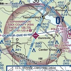
| Sectional chart |
|---|
|
| Airport distance calculator |
|---|
|
|
| Sunrise and sunset |
|---|
|
Times for 28-Sep-2025
| | Local
(UTC-4) | | Zulu
(UTC) |
|---|
| Morning civil twilight | | 06:35 | | 10:35 |
| Sunrise | | 07:01 | | 11:01 |
| Sunset | | 18:55 | | 22:55 |
| Evening civil twilight | | 19:21 | | 23:21 |
|
| Current date and time |
|---|
| Zulu (UTC) | 28-Sep-2025 20:44:02 |
|---|
| Local (UTC-4) | 28-Sep-2025 16:44:02 |
|---|
|
| METAR |
|---|
| KXSA | 282015Z AUTO 36004KT 10SM SCT035 26/18 A3010 RMK AO2 T02560182
|
|
| TAF |
|---|
KRIC
29nm SW | 281722Z 2818/2918 04007KT P6SM SCT015 BKN035 FM290000 VRB01KT P6SM SCT040 BKN100 FM291200 05005KT P6SM SCT025 OVC050
|
KNHK
34nm NE | 2815/2915 02012KT 9999 SCT030 SCT200 532409 533306 QNH3006INS FM282000 01008KT 9999 SCT250 533209 534104 QNH3007INS FM290000 VRB05KT 9999 FEW030 SCT200 500000 QNH3009INS TX25/2820Z TN19/2909Z COR 1627Z FN00296
|
|
| NOTAMs |
|---|
NOTAMs are issued by the DoD/FAA and will open in a separate window not controlled by AirNav.
|
|

