FAA INFORMATION EFFECTIVE 17 APRIL 2025
Location
| FAA Identifier: | PWK |
| Lat/Long: | 42-06-51.4060N 087-54-05.5470W
42-06.856767N 087-54.092450W
42.1142794,-87.9015408
(estimated) |
| Elevation: | 647 ft. / 197.2 m (surveyed) |
| Variation: | 02W (2000) |
| From city: | 18 miles NW of central business district of the associated city |
| Time zone: | UTC -5 (UTC -6 during Standard Time) |
| Zip code: | 60090 |
Airport Operations
| Airport use: | Open to the public |
| Activation date: | 02/1944 |
| Control tower: | yes |
| ARTCC: | CHICAGO CENTER |
| FSS: | KANKAKEE FLIGHT SERVICE STATION |
| NOTAMs facility: | PWK (NOTAM-D service available) |
| Attendance: | CONTINUOUS |
| Wind indicator: | lighted |
| Segmented circle: | yes |
| Lights: | ACTVT REIL RWY 16 & 34; RLLS LGTS RWY 16; HIRL RWY 06/24; 16/34; MIRL RWY 12/30 - CTAF. |
| Beacon: | white-green (lighted land airport)
Operates sunset to sunrise. |
| International operations: | US CUST USER FEE ARPT. FOR CUST CLNC 2 HR MIN ADVN
NOTICE RQRD MON-FRI 1100-1900. CTC CUST AT
847-894-7292. |
Airport Communications
| CTAF: | 119.9 |
| UNICOM: | 122.95 |
| ATIS: | 124.2 |
| WX ASOS: | PHONE 847-465-0291 |
| EXECUTIVE GROUND: | 121.7 [0600-2200 MON-FRI & 0700-2200 SAT-SUN] |
| EXECUTIVE TOWER: | 119.9 [0600-2200 MON-FRI & 0700-2200 SAT-SUN] |
| CHICAGO APPROACH: | 120.55 125.0 |
| CHICAGO DEPARTURE: | 120.55 125.0 |
| CLEARANCE DELIVERY: | 124.7 124.7 ;WHEN TWR CLSD |
| WX ASOS at ORD (8 nm S): | PHONE 773-462-0118 |
| WX AWOS-3 at 06C (12 nm SW): | 128.275 ((847) 895-2887) |
| WX ASOS at UGN (19 nm N): | PHONE 847-782-0876 |
| WX ASOS at DPA (20 nm SW): | PHONE 630-587-3668 |
Nearby radio navigation aids
| VOR radial/distance | | VOR name | | Freq | | Var |
|---|
| OBKr163/6.8 | | NORTHBROOK VOR/DME | | 113.00 | | 02W |
| DPAr054/24.1 | | DUPAGE VOR/DME | | 108.40 | | 02E |
| JOTr027/38.8 | | JOLIET VOR/DME | | 112.30 | | 02E |
| CGTr336/39.1 | | CHICAGO HEIGHTS VORTAC | | 114.20 | | 02E |
Airport Services
| Fuel available: | 100LL JET-A1+ |
| Parking: | hangars and tiedowns |
| Airframe service: | MAJOR |
| Powerplant service: | MAJOR |
| Bottled oxygen: | HIGH/LOW |
| Bulk oxygen: | HIGH/LOW |
Runway Information
Runway 16/34
| Dimensions: | 5001 x 150 ft. / 1524 x 46 m |
| Surface: | asphalt/grooved, in good condition |
| Weight bearing capacity: | | PCN 39 /F/D/X/T | | Single wheel: | 72.0 | | Double wheel: | 98.0 |
|
| Runway edge lights: | high intensity |
| RUNWAY 16 | | RUNWAY 34 |
| Latitude: | 42-07.399733N | | 42-06.633105N |
| Longitude: | 087-54.427585W | | 087-54.024297W |
| Elevation: | 642.8 ft. | | 644.1 ft. |
| Traffic pattern: | left | | left
WHEN CIRCLING E OF THE ARPT FOR RIGHT TFC RWY 34, ACFT HAVE OFTEN MISALIGNED WITH RWY 30. EXER VIGILANCE AND VFY RWY ALNMT. |
| Runway heading: | 161 magnetic, 159 true | | 341 magnetic, 339 true |
| Markings: | precision, in good condition | | precision, in good condition |
| Visual slope indicator: | 4-light PAPI on left (3.00 degrees glide path)
PAPI UNUSBL BYD 8 DEG LEFT & 9 DEG RIGHT OF CNTRLN. | | 4-light PAPI on left (3.00 degrees glide path)
PAPI UNUSBL BYD 8 DEG LEFT & RIGHT OF CNTRLN. |
| Approach lights: | RLLS
NSTD SPACING. | | |
| Runway end identifier lights: | yes | | yes |
| Touchdown point: | yes, no lights | | yes, no lights |
| Instrument approach: | ILS/DME | | |
| Obstructions: | 24 ft. pole, lighted, 629 ft. from runway, 417 ft. left of centerline, 18:1 slope to clear
CONTROLLING OBSTN EXCEEDS A 45 DEG SLP. | | 13 ft. road, 201 ft. from runway, 325 ft. left of centerline |
Runway 12/30
| Dimensions: | 4415 x 75 ft. / 1346 x 23 m |
| Surface: | asphalt/grooved, in good condition |
| Weight bearing capacity: | | PCN 39 /F/D/X/T | | Single wheel: | 18.0 | | Double wheel: | 28.0 |
|
| Runway edge lights: | medium intensity |
| RUNWAY 12 | | RUNWAY 30 |
| Latitude: | 42-06.923542N | | 42-06.582675N |
| Longitude: | 087-54.430120W | | 087-53.568047W |
| Elevation: | 644.9 ft. | | 639.7 ft. |
| Traffic pattern: | left | | right |
| Runway heading: | 120 magnetic, 118 true | | 300 magnetic, 298 true |
| Displaced threshold: | 295 ft. | | 432 ft. |
| Declared distances: | TORA:4415 TODA:4415 ASDA:4079 LDA:3785 | | TORA:4415 TODA:4415 ASDA:4157 LDA:3725 |
| Markings: | nonprecision, in good condition | | nonprecision, in good condition |
| Visual slope indicator: | 4-light PAPI on left (3.00 degrees glide path) | | 4-light PAPI on left (3.00 degrees glide path) |
| Runway end identifier lights: | yes | | yes |
| Touchdown point: | yes, no lights | | yes, no lights |
| Obstructions: | 42 ft. tree, 491 ft. from runway, 6:1 slope to clear
15 FT ROAD & 6 FT FENCE. | | 15 ft. road, 201 ft. from runway
+6 FT FENCE 0 FT FM THR; +20 FT TREES 0 FT & 50 FT FM THR; 15 FT ROAD. |
Runway 6/24
| Dimensions: | 3677 x 50 ft. / 1121 x 15 m |
| Surface: | asphalt, in fair condition |
| Weight bearing capacity: | | Single wheel: | 20.0 | | Double wheel: | 30.0 |
|
| Runway edge lights: | high intensity |
| RUNWAY 6 | | RUNWAY 24 |
| Latitude: | 42-06.628463N | | 42-06.899615N |
| Longitude: | 087-54.386465W | | 087-53.659605W |
| Elevation: | 646.7 ft. | | 637.9 ft. |
| Traffic pattern: | left | | right |
| Runway heading: | 065 magnetic, 063 true | | 245 magnetic, 243 true |
| Displaced threshold: | 373 ft. | | 1248 ft. |
| Markings: | basic, in fair condition | | basic, in fair condition |
| Visual slope indicator: | 4-light PAPI on left (3.00 degrees glide path) | | |
| Runway end identifier lights: | no | | no |
| Touchdown point: | yes, no lights | | yes, no lights |
| Obstructions: | 23 ft. pole, marked, 320 ft. from runway, 130 ft. right of centerline, 5:1 slope to clear
APCH RATIO 22:1 AT DSPLCD THR. | | 74 ft. tree, 382 ft. from runway, 120 ft. right of centerline, 2:1 slope to clear
14 FT ROAD & +40 FT TREES 150 FT & 50 FT L; 6 FT FENCE. |
Airport Ownership and Management from official FAA records
| Ownership: | Publicly-owned |
| Owner: | CITIES OF WHEELING & PROSPECT HGTS
1020 S. PLANT ROAD
WHEELING, IL 60090
Phone 847-537-2580 |
| Manager: | JEFF MILLER
1020 S. PLANT ROAD
WHEELING, IL 60090
Phone 847-537-2580 |
Additional Remarks
| E60-34 | ENGINEERED MATERIALS ARRESTING SYSTEM (EMAS) RY 34 DEP END: 230.82 FT IN LENGTH BY 170.10 FT IN WIDTH, SETBACK 304.18 FT FROM RY END. |
| E60-16 | ENGINEERED MATERIALS ARRESTING SYSTEM (EMAS) RY 16 DEP END: 242.97 FT IN LENGTH BY 170.10 FT IN WIDTH, SETBACK 35 FT FROM RY END. |
| - | NOISE SENSITIVE AREA N AND S OF ARPT. |
| - | CONDS NOT RPRTD; SUN 1530L-0630L ON MON, MON FM 2100L-0630L, TUES FM 1530L-0630L ON WED, WED FM 1530L-0630L ON THURS, THURS FROM 2100L-0630L ON FRI, FRI FM 2100L-0630L ON SAT, SAT 1530L-0630L ON SUN. |
| - | NOISE ABATEMENT PROCS: RWY 34 HOLD PAD PREFERRED RUN UP AREA FOR TURBINE ACFT; ALIGN ACFT AT 190 DEG WHILE WAITING TKOF OR RUN UPS. RWY 16 HOLD PAD; ALIGN ACFT AT 315 DEG. |
| - | NO EDGE LGTS ON TWY F, P, Q, T - REFLECTORS ONLY. |
| - | AREA 2 & 3, HANGAR 5 & 6 APRON, NE T HANGARS, SW T HANGARS PERMITTED TENANT ACFT PRKG ONLY. |
| - | ACFT TRANSVERSING NE HNGRS; ENTER ON QUEBEC EXIT ON PAPA. |
| - | RWY GUARD LGTS NOT AVBL AT ALL RWY AND TWY INTS. |
| - | NMRS CRANES INVOF ARPT. |
| - | FOR CD WHEN ATCT CLSD, AND IF UNA ON FREQ, CTC CHICAGO APCH AT 847-289-0926. |
| - | PREF MAINTENANCE RUN UP AREA: TXY C ABM THE TWR; EXHAUST FACING TWD CNTR OF ARPT. RWY 34 HOLD PAD: ALIGN ACFT AT 190 DEG WHILE WAITING TKOF OR RUN UPS. MAINTENANCE RUNS AT THE 16 HOLD PAD PROHIBITIED. NO TURBINE ENG RUNS BTWN 2200L AND 0700L ALL WEEK. RADIO CTC REQUIRED WITH TOWER AT ALL TIMES. |
| - | TAXILANE P; TWR VIEW PRLY OBSTD BY HNGRS & TREES. TAXILANE Q AND NE HNGRS; TWR VIEW PRLY OBSTD BY BLDGS & TREES. TWY T AND SW HNGRS; TWR VIEW PRLY OBSTD BY HNGRS. |
| - | TWY F CLSD TO ACFT WINGSPAN MORE THAN 40 FT. |
| - | TWY B BTN APCH END RWY 24 AND AREA 2 RAMP CLSD TO ACFT WINGSPAN MORE THAN 40 FT. |
| - | ALL TRAN ACFT CLRG CUSTOMS MUST UTILIZE FBO AFT CLRD. U.S. CBP USER FEES BILLED BY FBOS ONLY. |
| - | PWK ARRIVAL ALERT NOTICE PUBLISHED FOR LANDING NORTHWEST RWY 34 AND RWY 30. VISIT FAA.GOV/AIRPORTS/RUNWAY_SAFETY/HOTSPOTS/AAN/PWK-ARRIVAL-ALERT-NOTICE.PDF |
| - | AREA 3 CLSD PERMLY. |
| - | BIRDS & WILDLIFE ON AND INVOF ARPT. PYROTECHNICS, WILDLIFE LASER BIRD CTL IN USE. |
| - | (CONTACT ADDRESS LINE 1) EMAIL ADDRESS: OPS@CHIEXEC.COM |
| - | (CONTACT NAME) MON-FRI 0700-1530L |
| - | (CONTACT PHONE NR) EXT 119 & EXT 114. |
Instrument Procedures
NOTE: All procedures below are presented as PDF files. If you need a reader for these files, you should download the free Adobe Reader.NOT FOR NAVIGATION. Please procure official charts for flight.
FAA instrument procedures published for use from 17 April 2025 at 0901Z to 15 May 2025 at 0900z.
STARs - Standard Terminal Arrivals |
|---|
| GOPAC THREE (RNAV) | |
download (233KB) |
IAPs - Instrument Approach Procedures |
|---|
| ILS OR LOC RWY 16 | |
download (248KB) |
| RNAV (GPS) RWY 16 | |
download (246KB) |
| RNAV (GPS) RWY 30 | |
download (227KB) |
| VOR RWY 16 | |
download (260KB) |
| NOTE: Special Alternate Minimums apply | |
download (162KB) |
Departure Procedures |
|---|
| JORJO FIVE (RNAV) | |
download (269KB) |
| MONKZ FIVE (RNAV) | |
2 pages:
[1] [2] (374KB) |
| PAL-WAUKEE SIX | |
download (219KB) |
| NOTE: Special Take-Off Minimums/Departure Procedures apply | |
download (482KB) |
Other nearby airports with instrument procedures:
KORD - Chicago O'Hare International Airport (8 nm S)
C81 - Campbell Airport (15 nm NW)
KUGN - Waukegan National Airport (19 nm N)
3CK - Lake in the Hills Airport (20 nm W)
KDPA - DuPage Airport (20 nm SW)
|
|

Road maps at:
MapQuest
Bing
Google
| Aerial photo |
|---|
WARNING: Photo may not be current or correct
 Photo credit: Chicago Jet Charter Flights by GiveJet jetcharterrewards.com/chicago.htm
Photo taken 20-Nov-2014
looking northwest.
Photo credit: Chicago Jet Charter Flights by GiveJet jetcharterrewards.com/chicago.htm
Photo taken 20-Nov-2014
looking northwest.
Do you have a better or more recent aerial photo of Chicago Executive Airport that you would like to share? If so, please send us your photo.
|
| Sectional chart |
|---|
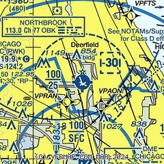
|
CAUTION: Diagram may not be current
 Download PDF
of official airport diagram from the FAA
| Airport distance calculator |
|---|
|
|
| Sunrise and sunset |
|---|
|
Times for 06-May-2025
| | Local
(UTC-5) | | Zulu
(UTC) |
|---|
| Morning civil twilight | | 05:11 | | 10:11 |
| Sunrise | | 05:42 | | 10:42 |
| Sunset | | 19:55 | | 00:55 |
| Evening civil twilight | | 20:26 | | 01:26 |
|
| Current date and time |
|---|
| Zulu (UTC) | 07-May-2025 00:49:07 |
|---|
| Local (UTC-5) | 06-May-2025 19:49:07 |
|---|
|
| METAR |
|---|
| KPWK | 062352Z 06006KT 10SM CLR 19/09 A3000 RMK AO2 SLP159 T01940094 10250 20194 53009 $
|
KORD
8nm S | 062351Z 04009KT 10SM FEW070 SCT085 23/10 A2997 RMK AO2 SLP148 T02330100 10250 20217 53003
|
K06C
12nm SW | 070015Z AUTO 00000KT 10SM SCT080 23/10 A2998 RMK AO2 T02300095
|
KUGN
18nm N | 062351Z 15005KT 10SM CLR 17/ A2998 RMK AO2 SLP150 T0172 10250 20161 53003 $
|
KDPA
20nm SW | 062352Z 32008KT 10SM SCT090 23/09 A2997 RMK AO2 SLP149 T02280089 10250 20217 53001
|
|
| TAF |
|---|
KORD
8nm S | 062243Z 0623/0724 30010KT P6SM BKN060 FM062330 05008KT P6SM FEW060 FM070100 VRB05KT P6SM SKC FM071400 03010KT P6SM SKC FM072000 02015G25KT P6SM SCT250
|
KDPA
20nm SW | 062100Z 0621/0718 30011KT P6SM BKN060 FM070100 26005KT P6SM FEW080 FM071500 05007KT P6SM SCT250
|
|
| NOTAMs |
|---|
NOTAMs are issued by the DoD/FAA and will open in a separate window not controlled by AirNav.
|
|


