FAA INFORMATION EFFECTIVE 19 MARCH 2026
Location
| FAA Identifier: | S19 |
| Lat/Long: | 33-54-29.1490N 082-16-00.9480W
33-54.485817N 082-16.015800W
33.9080969,-82.2669300
(estimated) |
| Elevation: | 459.4 ft. / 140.0 m (surveyed) |
| Variation: | 04W (1985) |
| From city: | 1 mile SE of MC CORMICK, SC |
| Time zone: | UTC -4 (UTC -5 during Standard Time) |
| Zip code: | 29835 |
Airport Operations
| Airport use: | Open to the public |
| Activation date: | 09/1979 |
| Control tower: | no |
| ARTCC: | ATLANTA CENTER |
| FSS: | ANDERSON FLIGHT SERVICE STATION |
| NOTAMs facility: | AND (NOTAM-D service available) |
| Attendance: | UNATNDD |
| Wind indicator: | yes |
| Segmented circle: | yes |
| Beacon: | white-green (lighted land airport)
BCN O/S. BCN O/S. |
Airport Communications
Nearby radio navigation aids
| VOR radial/distance | | VOR name | | Freq | | Var |
|---|
| IRQr341/13.1 | | COLLIERS VORTAC | | 113.90 | | 04W |
| NDB name | | Hdg/Dist | | Freq | | Var | | ID |
|---|
| EMORY | | 337/29.9 | | 385 | | 04W | | EMR | . -- .-. |
| AIKEN | | 304/33.2 | | 347 | | 06W | | AIK | .- .. -.- |
Airport Services
| Parking: | tiedowns |
| Airframe service: | NONE |
| Powerplant service: | NONE |
| Bottled oxygen: | NONE |
| Bulk oxygen: | NONE |
Runway Information
Runway 18/36
| Dimensions: | 3598 x 75 ft. / 1097 x 23 m |
| Surface: | asphalt, in fair condition |
| Weight bearing capacity: | |
| RUNWAY 18 | | RUNWAY 36 |
| Latitude: | 33-54.781567N | | 33-54.189033N |
| Longitude: | 082-16.032250W | | 082-15.997867W |
| Elevation: | 451.3 ft. | | 459.4 ft. |
| Traffic pattern: | left | | right |
| Runway heading: | 181 magnetic, 177 true | | 001 magnetic, 357 true |
| Markings: | basic, in good condition | | basic, in good condition |
| Runway end identifier lights: | no | | no |
| Touchdown point: | yes, no lights | | yes, no lights |
| Obstructions: | 32 ft. tree, 766 ft. from runway, 110 ft. left of centerline, 17:1 slope to clear
TRRN 15 FT HYR THAN RWY THLD 82 FT L OF CNTRLN. | | 70 ft. tree, 1062 ft. from runway, 174 ft. left of centerline, 12:1 slope to clear |
Airport Ownership and Management from official FAA records
| Ownership: | Publicly-owned |
| Owner: | MC CORMICK COUNTY
RT 2 BOX 84AA
MC CORMICK, SC 29835
Phone 864-852-2231 |
| Manager: | MARK WARNER
610 S. MINE STREET
MC CORMICK, SC 29835
Phone 864-602-9082
COUNTY ADMIR. |
Additional Remarks
| - | NO NGT OPS. |
| - | FOR CD CTC AUGUSTA APCH AT 706-771-1777. WHEN AUGUSTA APCH CLSD, FOR CD CTC ATLANTA ARTCC AT 770-210-7692. |
Instrument Procedures
There are no published instrument procedures at S19.
Some nearby airports with instrument procedures:
KGRD - Greenwood County Airport (21 nm N)
6J4 - Saluda County Airport (24 nm E)
KHQU - Thomson/McDuffie County Airport (26 nm SW)
KIIY - Washington/Wilkes County Airport (28 nm W)
KDNL - Daniel Field Airport (29 nm SE)
|
|

Road maps at:
MapQuest
Bing
Google
| Aerial photo |
|---|
WARNING: Photo may not be current or correct
 Photo by Richard Helton
Do you have a better or more recent aerial photo of Mc Cormick County Airport that you would like to share? If so, please send us your photo.
|
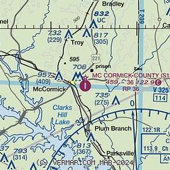
| Sectional chart |
|---|
|
| Airport distance calculator |
|---|
|
|
| Sunrise and sunset |
|---|
|
Times for 08-Apr-2026
| | Local
(UTC-4) | | Zulu
(UTC) |
|---|
| Morning civil twilight | | 06:43 | | 10:43 |
| Sunrise | | 07:08 | | 11:08 |
| Sunset | | 19:54 | | 23:54 |
| Evening civil twilight | | 20:19 | | 00:19 |
|
| Current date and time |
|---|
| Zulu (UTC) | 08-Apr-2026 15:29:58 |
|---|
| Local (UTC-4) | 08-Apr-2026 11:29:58 |
|---|
|
| METAR |
|---|
KGRD
21nm N | 081456Z AUTO 04010G19KT 10SM CLR 13/01 A3047 RMK AO2 SLP315 T01330006 51018
|
KHQU
26nm SW | 081510Z AUTO 08011G15KT 10SM CLR 15/02 A3047 RMK AO2
|
KIIY
28nm W | 081515Z AUTO 06009G16KT 020V090 10SM CLR 14/03 A3044 RMK AO2 T01380025
|
KDNL
29nm SE | 081453Z AUTO 07011KT 10SM CLR 15/00 A3041 RMK AO2 SLP296 T01500000 51022
|
KEBA
30nm W | 081515Z AUTO 06009KT 030V100 10SM CLR 14/02 A3045 RMK AO2 T01350024
|
KAIK
33nm SE | 081515Z AUTO 06014G21KT 10SM CLR 15/M01 A3044 RMK AO2 T01511008
|
KAGS
36nm SE | 081453Z 07010G20KT 10SM CLR 16/01 A3040 RMK AO2 SLP293 T01560011 51023
|
KLUX
39nm NE | 081515Z AUTO 07008G15KT 350V090 10SM CLR 12/00 A3047 RMK AO2
|
KEOE
39nm NE | 081515Z AUTO 04010G16KT M1/4SM HZ VV000 13/M02 A3049 RMK AO2 LTG DSNT NE
|
KAND
42nm NW | 081456Z AUTO 06015KT 10SM CLR 13/01 A3046 RMK AO2 PK WND 06026/1401 SLP312 T01330006 51019
|
|
| TAF |
|---|
KDNL
29nm SE | 081430Z 0814/0912 06015G24KT P6SM SCT250 FM090000 06008KT P6SM SCT250
|
KAIK
33nm SE | 081430Z 0814/0912 06015G24KT P6SM SCT250 FM090000 06006KT P6SM SCT250
|
KAGS
36nm SE | 081430Z 0814/0912 06014G22KT P6SM SCT250 FM090000 06006KT P6SM SCT250
|
|
| NOTAMs |
|---|
NOTAMs are issued by the DoD/FAA and will open in a separate window not controlled by AirNav.
|
|

