FAA INFORMATION EFFECTIVE 09 JULY 2026
Location
| FAA Identifier: | 10G |
| Lat/Long: | 40-32-12.1245N 081-57-21.3882W
40-32.202075N 081-57.356470W
40.5367013,-81.9559412
(estimated) |
| Elevation: | 1226.5 ft. / 373.8 m (surveyed) |
| Variation: | 08W (2015) |
| From city: | 2 miles WSW of MILLERSBURG, OH |
| Time zone: | UTC -4 (UTC -5 during Standard Time) |
| Zip code: | 44654 |
Airport Operations
| Airport use: | Open to the public |
| Activation date: | 03/1962 |
| Control tower: | no |
| ARTCC: | INDIANAPOLIS CENTER |
| FSS: | CLEVELAND FLIGHT SERVICE STATION |
| NOTAMs facility: | 10G (NOTAM-D service available) |
| Attendance: | MON-FRI 0800-1700, ALL SAT 0900-1700, ALL SUN 1200-1700
EXC MAJOR HOLS. |
| Wind indicator: | lighted |
| Segmented circle: | no |
| Lights: | ACTVT REIL RWY 09 & 27; PAPI RWY 27; MIRL RWY 09/27 - 123.4. |
| Beacon: | white-green (lighted land airport)
Operates sunset to sunrise. |
Airport Communications
| CTAF/UNICOM: | 123.0 |
| WX AWOS-3: | 128.325 (330-674-6279) |
| WX AWOS-3 at I40 (14 nm S): | 118.875 (740-295-7370) |
- APCH/DEP SVC PRVDD BY INDIANAPOLIS ARTCC ON FREQS 124.45/323.275 (ZANESVILLE RCAG).
Nearby radio navigation aids
| VOR radial/distance | | VOR name | | Freq | | Var |
|---|
| BSVr247/26.8 | | BRIGGS VOR/DME | | 114.05 | | 04W |
| APEr057/37.0 | | APPLETON VORTAC | | 116.70 | | 06W |
Airport Services
| Fuel available: | 100LL JET-A
A:ANTI-ICING AVBL ON DLVY. |
| Parking: | hangars and tiedowns |
| Airframe service: | MAJOR |
| Powerplant service: | MAJOR |
| Bottled oxygen: | HIGH |
| Bulk oxygen: | NONE |
Runway Information
Runway 9/27
| Dimensions: | 4400 x 75 ft. / 1341 x 23 m |
| Surface: | asphalt, in good condition |
| Weight bearing capacity: | | Single wheel: | 14.0 | | Double wheel: | 25.0 |
|
| Runway edge lights: | medium intensity |
| RUNWAY 9 | | RUNWAY 27 |
| Latitude: | 40-32.182148N | | 40-32.222002N |
| Longitude: | 081-57.830652W | | 081-56.882287W |
| Elevation: | 1226.5 ft. | | 1183.2 ft. |
| Traffic pattern: | left | | left |
| Runway heading: | 095 magnetic, 087 true | | 275 magnetic, 267 true |
| Markings: | nonprecision, in good condition | | nonprecision, in good condition |
| Visual slope indicator: | | | 2-light PAPI on left (3.00 degrees glide path) |
| Runway end identifier lights: | yes | | yes |
| Touchdown point: | yes, no lights | | yes, no lights |
| Obstructions: | 70 ft. trees, 1550 ft. from runway, 215 ft. right of centerline, 19:1 slope to clear | | none |
Airport Ownership and Management from official FAA records
| Ownership: | Publicly-owned |
| Owner: | HOLMES CO ARPT AUTH
10 S CLAY ST
MILLERSBURG, OH 44654-1329
Phone 330-674-8625 |
| Manager: | LARRY CLARK
4501 TOWNSHIP ROAD 307
MILLERSBURG, OH 44654-9656
Phone 330-674-0674
CELL 330-231-3715. |
Additional Remarks
| A30A-27 | CALM WIND RWY. |
| - | FOR CD CTC INDIANAPOLIS ARTCC AT 317-247-2411. |
| - | DEER, BIRDS, & OTR WILDLIFE ON & INVOF ARPT. |
Instrument Procedures
NOTE: All procedures below are presented as PDF files. If you need a reader for these files, you should download the free Adobe Reader.NOT FOR NAVIGATION. Please procure official charts for flight.
FAA instrument procedures published for use from 09 July 2026 at 0901Z to 06 August 2026 at 0900Z.
IAPs - Instrument Approach Procedures |
|---|
| RNAV (GPS) RWY 09 | |
download (190KB) |
| RNAV (GPS) RWY 27 | |
download (199KB) |
| NOTE: Special Alternate Minimums apply | |
download (168KB) |
| NOTE: Special Take-Off Minimums/Departure Procedures apply | |
download (234KB) |
Other nearby airports with instrument procedures:
I40 - Richard Downing Airport (14 nm S)
KBJJ - Wayne County Airport (21 nm N)
KPHD - Harry Clever Field Airport (25 nm E)
3G4 - Ashland County Airport (26 nm NW)
4I3 - Knox County Airport (29 nm SW)
|
|

Road maps at:
MapQuest
Bing
Google
| Aerial photo |
|---|
WARNING: Photo may not be current or correct

Do you have a better or more recent aerial photo of Holmes County Airport that you would like to share? If so, please send us your photo.
|
| Sectional chart |
|---|
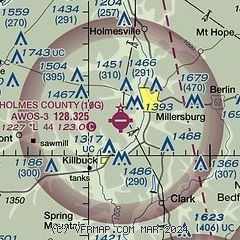
|
| Airport distance calculator |
|---|
|
|
| Sunrise and sunset |
|---|
|
Times for 26-Jul-2026
| | Local
(UTC-4) | | Zulu
(UTC) |
|---|
| Morning civil twilight | | 05:49 | | 09:49 |
| Sunrise | | 06:20 | | 10:20 |
| Sunset | | 20:48 | | 00:48 |
| Evening civil twilight | | 21:20 | | 01:20 |
|
| Current date and time |
|---|
| Zulu (UTC) | 27-Jul-2026 01:04:30 |
|---|
| Local (UTC-4) | 26-Jul-2026 21:04:30 |
|---|
|
| METAR |
|---|
KBJJ
20nm N | 270056Z AUTO 28004KT 10SM CLR 22/19 A2991 RMK AO2 SLP123 T02170189 $
|
KPHD
25nm E | 270053Z AUTO 00000KT 10SM CLR 22/20 A2990 RMK AO2 SLP121 T02220200
|
K4I3
29nm SW | 270055Z AUTO 26002KT 10SM CLR 21/21 A2992 RMK AO2
|
KMFD
31nm NW | 270052Z 00000KT 10SM CLR 22/19 A2992 RMK AO2 SLP124 T02220194 $
|
KCAK
32nm NE | 270051Z 27006KT 10SM FEW036 SCT070 SCT250 23/18 A2990 RMK AO2 SLP117 T02330183
|
KZZV
35nm S | 270053Z AUTO 00000KT 10SM CLR 22/21 A2990 RMK AO2 SLP120 T02220206
|
KAKR
37nm NE | 270054Z AUTO 29005KT 10SM BKN075 24/19 A2989 RMK AO2 RAB2359E25 SLP115 P0002 T02390194
|
KCDI
38nm SE | 270055Z AUTO 00000KT 10SM CLR 21/21 A2991 RMK AO2 T02130207
|
KVTA
39nm SW | 270054Z AUTO 00000KT 10SM CLR 22/20 A2990 RMK AO2 SLP118 T02220200
|
|
| TAF |
|---|
KMFD
31nm NW | 261737Z 2618/2718 26006KT P6SM BKN035 FM270300 21003KT P6SM FEW250 FM271300 25007KT P6SM BKN250
|
KCAK
32nm NE | 261737Z 2618/2718 26006KT P6SM BKN045 FM270300 21003KT P6SM SCT250 FM271400 26007KT P6SM BKN250
|
KZZV
35nm S | 261735Z 2618/2718 28005KT P6SM BKN040 PROB30 2620/2623 6SM -SHRA FM270000 00000KT P6SM SCT100 BKN200
|
|
| NOTAMs |
|---|
NOTAMs are issued by the DoD/FAA and will open in a separate window not controlled by AirNav.
|
|


