FAA INFORMATION EFFECTIVE 18 APRIL 2024
Location
| FAA Identifier: | 1I5 |
| Lat/Long: | 42-21-50.4000N 074-03-54.1000W
42-21.840000N 074-03.901667W
42.3640000,-74.0650278
(estimated) |
| Elevation: | 440 ft. / 134 m (estimated) |
| Variation: | 14W (1985) |
| From city: | 1 mile NW of FREEHOLD, NY |
| Time zone: | UTC -4 (UTC -5 during Standard Time) |
| Zip code: | 12431 |
Airport Operations
| Airport use: | Open to the public |
| Activation date: | 07/1969 |
| Control tower: | no |
| ARTCC: | BOSTON CENTER |
| FSS: | BURLINGTON FLIGHT SERVICE STATION |
| NOTAMs facility: | BTV (NOTAM-D service available) |
| Attendance: | APR-DEC 0900-DUSK |
| Wind indicator: | yes |
| Segmented circle: | no |
Airport Communications
| CTAF: | 122.85 |
| WX AWOS-3 at 1B1 (16 nm E): | 133.525 (518-828-2577) |
Nearby radio navigation aids
| VOR radial/distance | | VOR name | | Freq | | Var |
|---|
| ALBr220/25.7 | | ALBANY VORTAC | | 115.30 | | 13W |
| NDB name | | Hdg/Dist | | Freq | | Var | | ID |
|---|
| PHILMONT | | 307/16.6 | | 272 | | 13W | | PFH | .--. ..-. .... |
| HUNTER | | 205/30.0 | | 356 | | 14W | | HEU | .... . ..- |
| JOHNSTOWN | | 177/39.9 | | 523 | | 14W | | JJH | .--- .--- .... |
Airport Services
| Parking: | tiedowns |
| Airframe service: | NONE |
| Powerplant service: | NONE |
Runway Information
Runway 12/30
| Dimensions: | 2275 x 22 ft. / 693 x 7 m
100 FT BY 2640 FT TURF RWY ADJACENT TO PAVED RWY (S EDGE) BEGINNING AT 735 FT FROM RWY 30 THLD. |
| Surface: | asphalt, in poor condition
SURFACE BROKEN & SPALLING FOR ENTIRE LENGTH. |
| RUNWAY 12 | | RUNWAY 30 |
| Latitude: | 42-21.903982N | | 42-21.777210N |
| Longitude: | 074-04.139745W | | 074-03.664357W |
| Elevation: | 437.0 ft. | | 421.0 ft. |
| Traffic pattern: | left | | left |
| Runway heading: | 124 magnetic, 110 true | | 304 magnetic, 290 true |
| Markings: | none | | none |
| Obstructions: | 70 ft. trees, 812 ft. from runway, 85 ft. right of centerline, 8:1 slope to clear
10 FT HIGH FENCE APPROX. PARALLEL TO RWY, 42 FT LT., 50 - 700 FT FRM THSLD. | | 35 ft. trees, marked, 315 ft. from runway, 35 ft. left of centerline, 3:1 slope to clear
31 FT TREES IN APCH TO RWY 315 FT FM END OF RWY, 35 FT LEFT OF CNTRLN. |
Airport Ownership and Management from official FAA records
| Ownership: | Privately-owned |
| Owner: | FREEHOLD AIRPORT LLC.
C/O GERARD CALAMARI, 115 BURDEN LAKE ROAD
AVERILL PARK, NY 12018
Phone 518-966-8503 |
| Manager: | ROBERT PETT
PO BOX 304
FREEHOLD, NY 12431
Phone 518-253-4859 |
Airport Operational Statistics
| Aircraft based on the field: | | 27 | | Single engine airplanes: | | 13 | | Gliders airplanes: | | 13 | | Ultralights: | | 1 |
| |  | |
| Aircraft operations: avg 50/week * | | 85% | local general aviation | | 11% | transient general aviation | | 4% | military | | * for 12-month period ending 07 July 2023 | |
Additional Remarks
| A30A-12 | RGT TFC FOR GLIDERS RY 12 ONLY. |
| - | EXTENSIVE GLIDER ACTIVITY, ESPECIALLY ON WEEKENDS. |
| - | RY 12 ORCHARDS 100 FT LEFT & 112 FT RIGHT RY CNTRLN & 59 FT TREES IN APCH TO RY 288 FT FM THLD. |
| - | RGT TFC FOR GLIDERS RY 12 ONLY. |
| - | CONTACT AIRPORT MANAGER FOR FIELD CONDITIONS DEC 1 -APR 1; PH. 518-966-8503 |
| - | FOR CD CTC ALBANY APCH AT 518-862-2299. |
Instrument Procedures
There are no published instrument procedures at 1I5.
Some nearby airports with instrument procedures:
4B0 - South Albany Airport (16 nm NE)
1B1 - Columbia County Airport (16 nm E)
20N - Kingston-Ulster Airport (23 nm S)
KALB - Albany International Airport (26 nm NE)
KSCH - Schenectady County Airport (30 nm N)
|
|

Road maps at:
MapQuest
Bing
Google
| Aerial photo |
|---|
WARNING: Photo may not be current or correct
 Photo courtesy of Adam Pass, www.birddogaerials.com
Photo taken 25-Feb-2009
Photo courtesy of Adam Pass, www.birddogaerials.com
Photo taken 25-Feb-2009
Do you have a better or more recent aerial photo of Freehold Airport that you would like to share? If so, please send us your photo.
|
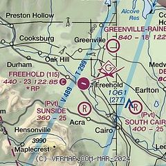
| Sectional chart |
|---|
|
| Airport distance calculator |
|---|
|
|
| Sunrise and sunset |
|---|
|
Times for 25-Apr-2024
| | Local
(UTC-4) | | Zulu
(UTC) |
|---|
| Morning civil twilight | | 05:29 | | 09:29 |
| Sunrise | | 05:59 | | 09:59 |
| Sunset | | 19:49 | | 23:49 |
| Evening civil twilight | | 20:19 | | 00:19 |
|
| Current date and time |
|---|
| Zulu (UTC) | 25-Apr-2024 08:47:18 |
|---|
| Local (UTC-4) | 25-Apr-2024 04:47:18 |
|---|
|
| METAR |
|---|
KALB
26nm NE | 250751Z 34003KT 10SM CLR 00/M03 A3029 RMK AO2 SLP259 T00001033
|
KSCH
30nm N | 250145Z 02008KT 10SM CLR 03/M01 A3018 RMK LAST
|
KPSF
35nm E | 250754Z AUTO 34003KT 10SM CLR M01/M09 A3020 RMK AO2 SLP226 T10111089
|
KAQW
45nm NE | 250752Z AUTO 26004KT 10SM CLR M01/M06 A3026 RMK AO2 SLP251 T10111056
|
KPOU
45nm S | 250753Z AUTO 02008KT 10SM CLR 03/M04 A3024 RMK AO2 SLP236 T00281039
|
|
| TAF |
|---|
KALB
26nm NE | 250520Z 2506/2606 33004KT P6SM SKC FM251200 01008KT P6SM SKC FM251800 32005KT P6SM SKC FM260000 29006KT P6SM SKC
|
|
| NOTAMs |
|---|
NOTAMs are issued by the DoD/FAA and will open in a separate window not controlled by AirNav.
|
|
