FAA INFORMATION EFFECTIVE 19 MARCH 2026
Location
| FAA Identifier: | 2W2 |
| Lat/Long: | 39-28-01.2660N 077-01-02.7550W
39-28.021100N 077-01.045917W
39.4670183,-77.0174319
(estimated) |
| Elevation: | 798.6 ft. / 243.4 m (surveyed) |
| Variation: | 11W (2000) |
| From city: | 7 miles S of WESTMINSTER, MD |
| Time zone: | UTC -4 (UTC -5 during Standard Time) |
| Zip code: | 21157 |
Airport Operations
| Airport use: | Open to the public |
| Activation date: | 07/1966 |
| Control tower: | no |
| ARTCC: | WASHINGTON CENTER |
| FSS: | LEESBURG FLIGHT SERVICE STATION |
| NOTAMs facility: | DCA (NOTAM-D service available) |
| Attendance: | 0900-1700
ARPT UNATNDD THANKSGIVING, CHRISTMAS & NEW YEARS DAY. |
| Wind indicator: | lighted |
| Segmented circle: | no |
| Lights: | ACTVT LIRL RWY 14/32 - CTAF. |
| Beacon: | white-green (lighted land airport)
ACTVT ROTG BCN - CTAF. |
Airport Communications
| CTAF/UNICOM: | 122.8 |
| POTOMAC APPROACH: | 125.525 |
| POTOMAC DEPARTURE: | 125.525 |
| WX AWOS-3 at DMW (8 nm N): | 121.25 (410-876-1281) |
| WX AWOS-3 at FDK (17 nm W): | PHONE 301-600-1457 |
| WX AWOS-3PT at GAI (19 nm S): | 128.275 (301-977-2971) |
Nearby radio navigation aids
| VOR radial/distance | | VOR name | | Freq | | Var |
|---|
| EMIr235/2.5 | | WESTMINSTER VORTAC | | 117.90 | | 08W |
| FDKr087/16.9 | | FREDERICK VOR/DME | | 116.85 | | 08W |
| BALr328/24.3 | | BALTIMORE VORTAC | | 115.10 | | 11W |
| DCAr010/36.5 | | WASHINGTON VOR/DME | | 111.00 | | 09W |
| AMLr041/38.2 | | ARMEL VOR/DME | | 113.50 | | 08W |
| MRBr090/38.8 | | MARTINSBURG VORTAC | | 112.10 | | 07W |
| NDB name | | Hdg/Dist | | Freq | | Var | | ID |
|---|
| ELLICOTT | | 325/15.5 | | 371 | | 11W | | FND | ..-. -. -.. |
| GEORGETOWN | | 018/32.6 | | 323 | | 09W | | GTN | --. - -. |
Airport Services
| Fuel available: | 100LL |
| Parking: | tiedowns |
| Airframe service: | NONE |
| Powerplant service: | NONE |
| Bottled oxygen: | NONE |
| Bulk oxygen: | NONE |
Runway Information
Runway 14/32
| Dimensions: | 1840 x 30 ft. / 561 x 9 m |
| Surface: | asphalt, in good condition |
| Runway edge lights: | low intensity
NSTD - LGTS 20 FT FM RWY EDGE. |
| RUNWAY 14 | | RUNWAY 32 |
| Latitude: | 39-28.107047N | | 39-27.935138N |
| Longitude: | 077-01.206832W | | 077-00.885015W |
| Elevation: | 760.3 ft. | | 798.6 ft. |
| Traffic pattern: | left | | left |
| Runway heading: | 136 magnetic, 125 true | | 316 magnetic, 305 true |
| Displaced threshold: | no | | 277 ft. |
| Markings: | nonprecision, in good condition | | nonprecision, in good condition |
| Visual slope indicator: | panels that may or may not be lighted, on left (4.00 degrees glide path) | | panels that may or may not be lighted, on left (7.00 degrees glide path) |
| Touchdown point: | yes, no lights | | yes, no lights |
| Obstructions: | 34 ft. trees, 693 ft. from runway, 134 ft. left of centerline, 14:1 slope to clear
40 FT TREES, 124 FT LEFT OF THLD. | | 88 ft. trees, 2316 ft. from runway, 121 ft. left of centerline, 24:1 slope to clear
10 FT PVT ROAD AT THLD; 60 FT TREES, 140 FT RIGHT. |
Airport Ownership and Management from official FAA records
| Ownership: | Privately-owned |
| Owner: | CLEARVIEW AIRPORT INC
526 OAK TREE ROAD
WESTMINSTER, MD 21157
Phone 410-795-1176 |
| Manager: | WALTER S. TEGELER, III
519 OAK TREE ROAD
WESTMINSTER, MD 21157
Phone 410-984-2434 |
Additional Remarks
| - | 60 FT DROP OFF 125 FT FM AER 14. |
| - | ULTRALIGHT ACT ON & INVOF ARPT. |
| - | UNL VEHICLE ACES TO ACFT MOVEMENT AREAS. |
| - | FOR CD CTC POTOMAC APCH AT 866-429-5882. |
Instrument Procedures
NOTE: All procedures below are presented as PDF files. If you need a reader for these files, you should download the free Adobe Reader.NOT FOR NAVIGATION. Please procure official charts for flight.
FAA instrument procedures published for use from 19 March 2026 at 0901Z to 16 April 2026 at 0900Z.
STARs - Standard Terminal Arrivals |
|---|
| TRSTN FOUR (RNAV) | |
2 pages:
[1] [2] (318KB) |
IAPs - Instrument Approach Procedures |
|---|
| RNAV (GPS)-B | |
download (166KB) |
| VOR-A | |
download (159KB) |
| NOTE: Special Take-Off Minimums/Departure Procedures apply | |
download (140KB) |
Other nearby airports with instrument procedures:
KDMW - Carroll County Regional Airport/Jack B Poage Field (8 nm N)
W50 - Davis Airport (15 nm SW)
KFDK - Frederick Municipal Airport (17 nm W)
KGAI - Montgomery County Airpark (19 nm S)
KBWI - Baltimore/Washington International Thurgood Marshall Airport (24 nm SE)
|
|

Road maps at:
MapQuest
Bing
Google
| Aerial photo |
|---|
WARNING: Photo may not be current or correct
 Photo by David Newcomer
Photo taken 13-Jan-2018
from 2,500' AGL looking south.
Photo by David Newcomer
Photo taken 13-Jan-2018
from 2,500' AGL looking south.
Do you have a better or more recent aerial photo of Clearview Airpark that you would like to share? If so, please send us your photo.
|
| Sectional chart |
|---|
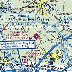
|
| Airport distance calculator |
|---|
|
|
| Sunrise and sunset |
|---|
|
Times for 13-Apr-2026
| | Local
(UTC-4) | | Zulu
(UTC) |
|---|
| Morning civil twilight | | 06:07 | | 10:07 |
| Sunrise | | 06:35 | | 10:35 |
| Sunset | | 19:42 | | 23:42 |
| Evening civil twilight | | 20:10 | | 00:10 |
|
| Current date and time |
|---|
| Zulu (UTC) | 13-Apr-2026 22:04:22 |
|---|
| Local (UTC-4) | 13-Apr-2026 18:04:22 |
|---|
|
| METAR |
|---|
KDMW
8nm N | 132155Z AUTO 23013G20KT 10SM CLR 27/12 A3003 RMK AO2
|
KFDK
16nm W | 132147Z COR 20012KT 10SM SCT110 26/14 A3004
|
KGAI
19nm S | 132156Z AUTO 23009G15KT 10SM CLR 25/12 A3007 RMK AO2 SLP192 T02500117
|
|
| TAF |
|---|
KBWI
24nm SE | 131726Z 1318/1424 22009G17KT P6SM FEW050 BKN150 OVC250 FM140000 24008KT P6SM SCT250 FM140400 25004KT P6SM FEW250 FM141400 24007KT P6SM BKN250 FM141900 23008G16KT P6SM BKN250
|
KMTN
29nm E | 131726Z 1318/1418 25010G19KT P6SM SCT040 OVC090 FM140000 23009KT P6SM SCT250 FM140300 19003KT P6SM SCT250 FM141500 18007KT P6SM SCT250 FM141700 19008G16KT P6SM FEW250
|
|
| NOTAMs |
|---|
NOTAMs are issued by the DoD/FAA and will open in a separate window not controlled by AirNav.
|
|

