FAA INFORMATION EFFECTIVE 09 JULY 2026
Location
| FAA Identifier: | AMT |
| Lat/Long: | 38-51-06.0210N 083-33-57.6260W
38-51.100350N 083-33.960433W
38.8516725,-83.5660072
(estimated) |
| Elevation: | 896 ft. / 273.1 m (surveyed) |
| Variation: | 04W (1985) |
| From city: | 4 miles NW of WEST UNION, OH |
| Time zone: | UTC -4 (UTC -5 during Standard Time) |
| Zip code: | 45693 |
Airport Operations
| Airport use: | Open to the public |
| Activation date: | 03/1972 |
| Control tower: | no |
| ARTCC: | INDIANAPOLIS CENTER |
| FSS: | DAYTON FLIGHT SERVICE STATION |
| NOTAMs facility: | DAY (NOTAM-D service available) |
| Attendance: | MON-FRI IREG, ALL SAT-SUN UNATNDD |
| Wind indicator: | lighted |
| Segmented circle: | no |
| Lights: | ACTVT REIL RWY 05 & 23; PAPI RWY 23; MIRL RWY 05/23 - CTAF. |
| Beacon: | white-green (lighted land airport)
Operates sunset to sunrise. |
Airport Communications
- APCH/DEP SVC PRVDD BY INDIANAPOLIS ARTCC ON FREQS 135.575/290.5 (PORTSMOUTH RCAG).
Nearby radio navigation aids
| VOR radial/distance | | VOR name | | Freq | | Var |
|---|
| MXQr166/36.4 | | MIDWEST VOR/DME | | 112.90 | | 04W |
| FLMr075/36.9 | | FALMOUTH VOR/DME | | 117.00 | | 04W |
| NDB name | | Hdg/Dist | | Freq | | Var | | ID |
|---|
| SPORTYS | | 118/33.2 | | 245 | | 04W | | PWF | .--. .-- ..-. |
Airport Services
| Parking: | tiedowns |
| Airframe service: | NONE |
| Powerplant service: | NONE |
| Bottled oxygen: | NONE |
| Bulk oxygen: | NONE |
Runway Information
Runway 5/23
| Dimensions: | 3558 x 65 ft. / 1084 x 20 m |
| Surface: | asphalt, in fair condition |
| Runway edge lights: | medium intensity |
| Runway edge markings: | FADED. |
| RUNWAY 5 | | RUNWAY 23 |
| Latitude: | 38-50.893600N | | 38-51.307073N |
| Longitude: | 083-34.226117W | | 083-33.694735W |
| Elevation: | 882.9 ft. | | 896.0 ft. |
| Traffic pattern: | left | | left |
| Runway heading: | 049 magnetic, 045 true | | 229 magnetic, 225 true |
| Markings: | nonprecision, in poor condition | | nonprecision, in poor condition |
| Visual slope indicator: | | | 4-light PAPI on left (3.30 degrees glide path) |
| Runway end identifier lights: | yes | | yes |
| Touchdown point: | yes, no lights | | yes, no lights |
| Obstructions: | 75 ft. trees, 546 ft. from runway, 238 ft. left of centerline, 4:1 slope to clear
+5 FT FENCE, 0-200 FT DIST, 210 FT L/R; +32-34 FT BRUSH/TREES, 0-200 FT DIST, 215 FT L. | | none
+5 FT FENCE, 0-200 FT DIST, 200 FT L; +5-15 FT BRUSH, 0-200 FT DIST, 200 FT L. |
Airport Ownership and Management from official FAA records
| Ownership: | Publicly-owned |
| Owner: | ADAMS CO ARPT AUTH
ADAMS CO COURTHOUSE, 110 W MAIN ST
WEST UNION, OH 45693-1347
Phone 937-544-3286 |
| Manager: | DAN MUSIC
3399 CROSS RD
WINCHESTER, OH 45697-9477
Phone 937-402-7207 |
Additional Remarks
| - | TWY MKD WITH REFLECTORS. |
| - | DEER, BIRDS, & OTR WILDLIFE ON & INVOF ARPT. |
| - | FOR CD CTC INDIANAPOLIS ARTCC AT 317-247-2411. |
Instrument Procedures
NOTE: All procedures below are presented as PDF files. If you need a reader for these files, you should download the free Adobe Reader.NOT FOR NAVIGATION. Please procure official charts for flight.
FAA instrument procedures published for use from 09 July 2026 at 0901Z to 06 August 2026 at 0900Z.
IAPs - Instrument Approach Procedures |
|---|
| RNAV (GPS) RWY 05 | |
download (189KB) |
| RNAV (GPS) RWY 23 | |
download (181KB) |
| NOTE: Special Take-Off Minimums/Departure Procedures apply | |
download (488KB) |
Other nearby airports with instrument procedures:
KGEO - Brown County Airport (15 nm W)
KHOC - Highland County Airport (20 nm N)
KFGX - Fleming-Mason Airport (20 nm SW)
I69 - Clermont County Airport (33 nm NW)
KPMH - Greater Portsmouth Regional Airport (34 nm E)
|
|

Road maps at:
MapQuest
Bing
Google
| Aerial photo |
|---|
WARNING: Photo may not be current or correct
 Photo by David Dietz
Photo taken 09-Jul-2009
looking northeast.
Photo by David Dietz
Photo taken 09-Jul-2009
looking northeast.
Do you have a better or more recent aerial photo of Alexander Salamon Airport that you would like to share? If so, please send us your photo.
|
| Sectional chart |
|---|
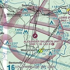
|
| Airport distance calculator |
|---|
|
|
| Sunrise and sunset |
|---|
|
Times for 31-Jul-2026
| | Local
(UTC-4) | | Zulu
(UTC) |
|---|
| Morning civil twilight | | 06:06 | | 10:06 |
| Sunrise | | 06:35 | | 10:35 |
| Sunset | | 20:46 | | 00:46 |
| Evening civil twilight | | 21:16 | | 01:16 |
|
| Current date and time |
|---|
| Zulu (UTC) | 31-Jul-2026 18:28:22 |
|---|
| Local (UTC-4) | 31-Jul-2026 14:28:22 |
|---|
|
| METAR |
|---|
KFGX
20nm SW | 311815Z AUTO 16006KT 10SM SCT055 30/16 A3004 RMK AO2 T03010158
|
KI69
33nm NW | 311816Z AUTO 11004KT 10SM SCT050 SCT060 29/17 A3004 RMK AO1 T02910166
|
KPMH
34nm E | 311815Z AUTO 15004KT 10SM CLR 30/17 A3002 RMK AO2
|
KEOP
35nm NE | 311815Z AUTO VRB03KT 10SM FEW047 29/20 A3001 RMK AO2
|
KILN
37nm N | 311754Z AUTO VRB03KT 10SM FEW050 FEW060 28/17 A3004 RMK AO2 SLP164 T02780167 10278 20183 55008 $
|
KSYM
38nm S | 311815Z AUTO 22006KT 10SM FEW055 29/15 A3001 RMK AO2
|
KK62
40nm W | 311815Z AUTO 00000KT 10SM SCT050 30/16 A3003 RMK AO2
|
|
| TAF |
|---|
KILN
37nm N | 311734Z 3118/0118 15006KT P6SM SCT050 BKN250 PROB30 0106/0111 -SHRA FM011100 15008KT P6SM -SHRA OVC040 FM011600 15010G18KT P6SM -SHRA SCT025 OVC040 PROB30 0116/0118 -TSRA BKN040CB
|
KSYM
38nm S | 311725Z 3118/0118 VRB03KT P6SM FEW200 FM011200 VRB03KT P6SM SCT050 OVC100 FM011500 18005KT P6SM -SHRA OVC050 PROB30 0115/0118 3SM -TSRA SCT020 BKN040CB
|
KLUK
42nm W | 311734Z 3118/0118 15006KT P6SM SCT040 BKN250 PROB30 0106/0109 -SHRA FM010900 15008KT P6SM -SHRA SCT050 OVC080
|
|
| NOTAMs |
|---|
NOTAMs are issued by the DoD/FAA and will open in a separate window not controlled by AirNav.
|
|


