FAA INFORMATION EFFECTIVE 19 FEBRUARY 2026
Location
| FAA Identifier: | CBE |
| Lat/Long: | 39-36-55.1010N 078-45-41.3220W
39-36.918350N 078-45.688700W
39.6153058,-78.7614783
(estimated) |
| Elevation: | 775 ft. / 236.2 m (surveyed) |
| Variation: | 10W (2010) |
| From city: | 2 miles S of CUMBERLAND, MD |
| Time zone: | UTC -5 (UTC -4 during Daylight Saving Time) |
| Zip code: | 26767 |
Airport Operations
| Airport use: | Open to the public |
| Activation date: | 03/1944 |
| Control tower: | no |
| ARTCC: | CLEVELAND CENTER |
| FSS: | ELKINS FLIGHT SERVICE STATION [703-724-4288] |
| NOTAMs facility: | EKN (NOTAM-D service available) |
| Attendance: | 0800-2000 |
| Pattern altitude: | 1799 ft. MSL |
| Wind indicator: | lighted |
| Segmented circle: | yes |
| Lights: | ACTVT REIL RWY 23; HIRL RWY 05/23; LIRL RWY 11/29; & TWY LGTS - CTAF. |
| Beacon: | white-green (lighted land airport)
ROTG BCN LOCATED OFF ARPT. Operates sunset to sunrise. |
Airport Communications
| CTAF/UNICOM: | 122.8 |
| WX AWOS-3: | 128.625 (304-738-0451) |
| JOHNSTOWN APPROACH: | 121.2 |
| JOHNSTOWN DEPARTURE: | 121.2 |
- APCH/DEP SVC PRVDD BY CLEVELAND ARTCC (ZOB) ON FREQS 124.4/327.1 (ALTOONA RCAG) WHEN JOHNSTOWN APCH CTL CLSD.
Nearby radio navigation aids
| VOR radial/distance | | VOR name | | Freq | | Var |
|---|
| ESLr030/25.7 | | KESSEL VOR/DME | | 110.80 | | 06W |
Airport Services
| Fuel available: | 100LL JET-A |
| Parking: | hangars and tiedowns |
| Airframe service: | NONE |
| Powerplant service: | NONE |
| Bottled oxygen: | HIGH/LOW
BOTTLE OXY AVBL FM 0800-1500 MON-FRI BY PRIOR ARNGMT, CALL 304-738-0002. |
| Bulk oxygen: | HIGH/LOW
BULK OXY AVBL FM 0800-1500 MON-FRI BY PRIOR ARNGMT, CALL 304-738-0002. |
Runway Information
Runway 5/23
| Dimensions: | 5047 x 150 ft. / 1538 x 46 m |
| Surface: | asphalt, in fair condition |
| Weight bearing capacity: | | Single wheel: | 38.0 | | Double wheel: | 52.0 |
|
| Runway edge lights: | high intensity |
| Runway edge markings: | FADED |
| RUNWAY 5 | | RUNWAY 23 |
| Latitude: | 39-36.664153N | | 39-37.309615N |
| Longitude: | 078-45.885550W | | 078-45.208235W |
| Elevation: | 721.9 ft. | | 775.0 ft. |
| Traffic pattern: | right | | left |
| Runway heading: | 049 magnetic, 039 true | | 229 magnetic, 219 true |
| Markings: | nonprecision, in poor condition | | precision, in poor condition |
| Visual slope indicator: | | | 4-light PAPI on left (3.59 degrees glide path) |
| Runway end identifier lights: | | | yes |
| Touchdown point: | yes, no lights | | yes, no lights |
| Instrument approach: | | | LOC/DME |
| Obstructions: | 6 ft. trees, 308 ft. from runway, 5 ft. left of centerline, 18:1 slope to clear | | none |
Runway 11/29
| Dimensions: | 3000 x 150 ft. / 914 x 46 m |
| Surface: | asphalt, in fair condition |
| Weight bearing capacity: | |
| Runway edge lights: | low intensity
NSTD LIRL FM RWY 11 THR TO RWY 11 DSPLCD THR, DUE TO IMPROPER LENS COLORS AND SPACING. |
| Runway edge markings: | FADED |
| RUNWAY 11 | | RUNWAY 29 |
| Latitude: | 39-36.833032N | | 39-36.773045N |
| Longitude: | 078-46.244277W | | 078-45.610183W |
| Elevation: | 721.2 ft. | | 727.0 ft. |
| Traffic pattern: | left | | left |
| Runway heading: | 107 magnetic, 097 true | | 287 magnetic, 277 true |
| Displaced threshold: | 560 ft. | | no |
| Markings: | basic, in good condition | | nonprecision, in poor condition |
| Touchdown point: | yes, no lights | | yes, no lights |
| Obstructions: | 336 ft. hill, 4187 ft. from runway, 11:1 slope to clear | | none |
Airport Ownership and Management from official FAA records
| Ownership: | Publicly-owned |
| Owner: | POTOMAC HIGHLAND ARPT AUTH
165 TERMINAL LOOP
WILEY FORD, WV 26767
Phone 304-738-0002 |
| Manager: | HAROLD KELLEY
165 TERMINAL LOOP
WILEY FORD, WV 26767
Phone 304-738-0002 |
Additional Remarks
| - | RWY 11 NGT OPNS & ANY LNDGS NOT RECOMMENDED DUE TO HIGH TERRAIN. |
| - | GLIDER OPNS W OF ARPT USE RWY 11 FOR DEP; RWY 29 FOR ARR. |
| - | DEER/BIRDS ON & INVOF ARPT. |
| - | RWY 23 900 FT TWY ALIGNED WITH RWY WEST END. |
| - | RWY 05 APCH HAS RAPIDLY RISING TERRAIN 696 FT L, 2000 FT FM THR. |
| - | FOR CD CTC JOHNSTOWN APCH AT 814-532-5960, WHEN APCH CLSD CTC CLEVELAND ARTCC AT 440-774-0213. |
| - | COLD TEMPERATURE AIRPORT. ALTITUDE CORRECTION REQUIRED AT OR BELOW -14C. |
Instrument Procedures
NOTE: All procedures below are presented as PDF files. If you need a reader for these files, you should download the free Adobe Reader.NOT FOR NAVIGATION. Please procure official charts for flight.
FAA instrument procedures published for use from 19 February 2026 at 0901Z to 19 March 2026 at 0900Z.
IAPs - Instrument Approach Procedures |
|---|
| RNAV (GPS) RWY 05 | |
download (238KB) |
| RNAV (GPS) RWY 23 | |
download (319KB) |
| LOC/DME RWY 23 | |
download (300KB) |
| NOTE: Special Alternate Minimums apply | |
download (41KB) |
| NOTE: Special Take-Off Minimums/Departure Procedures apply | |
download (217KB) |
Other nearby airports with instrument procedures:
2G4 - Garrett County Airport (27 nm W)
W35 - Potomac Airpark (28 nm E)
2G9 - Somerset County Airport (28 nm NW)
KHMZ - Bedford County Airport (30 nm N)
KMRB - Eastern WV Regional Airport/Shepherd Field (38 nm E)
|
|

Road maps at:
MapQuest
Bing
Google
| Aerial photo |
|---|
WARNING: Photo may not be current or correct
 Photo by David Newcomer
Taken in November 2017
from 3,000' AGL looking west.
Photo by David Newcomer
Taken in November 2017
from 3,000' AGL looking west.
Do you have a better or more recent aerial photo of Greater Cumberland Regional Airport that you would like to share? If so, please send us your photo.
|
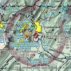
| Sectional chart |
|---|
|
| Airport distance calculator |
|---|
|
|
| Sunrise and sunset |
|---|
|
Times for 03-Mar-2026
| | Local
(UTC-5) | | Zulu
(UTC) |
|---|
| Morning civil twilight | | 06:19 | | 11:19 |
| Sunrise | | 06:46 | | 11:46 |
| Sunset | | 18:08 | | 23:08 |
| Evening civil twilight | | 18:35 | | 23:35 |
|
| Current date and time |
|---|
| Zulu (UTC) | 03-Mar-2026 16:06:46 |
|---|
| Local (UTC-5) | 03-Mar-2026 11:06:46 |
|---|
|
| METAR |
|---|
| KCBE | 031555Z AUTO 33003KT 10SM OVC010 02/00 A3042 RMK AO2 T00220004
|
|
| TAF |
|---|
KMRB
38nm E | 031140Z 0312/0412 12004KT 5SM -FZRA BKN008 OVC019 FM031400 15004KT 3SM -DZ BR OVC007 FM032100 15005KT 4SM -RA BR OVC009 FM040100 18006KT 3SM -RA BR OVC008 FM040900 00000KT P6SM OVC007
|
KJST
42nm N | 031124Z 0312/0412 17007KT 6SM -FZRA BR OVC004 FM031600 18008KT 4SM -RA BR BKN006 OVC050 FM031800 17008KT 3SM -SHRA BR SCT008 OVC020 WS020/24038KT FM032100 20008KT 1SM -SHRA BR OVC004 WS020/26038KT FM040100 21008KT 3/4SM -RA BR OVC003 WS020/27040KT FM040300 24006KT 1/2SM RA FG OVC003 WS020/27042KT FM040700 27005KT 1/2SM FG OVC003
|
KAOO
46nm NE | 031124Z 0312/0412 17005KT 6SM -FZRA BR OVC007 FM031300 16005KT 2SM -FZRA BR OVC004 FM031600 17007KT 3SM -RA BR OVC006 FM031800 17005KT 5SM -SHRA BR OVC009 FM032100 18005KT 1 1/2SM -RA BR OVC007 FM040700 22002KT 1SM BR OVC003
|
|
| NOTAMs |
|---|
NOTAMs are issued by the DoD/FAA and will open in a separate window not controlled by AirNav.
|
|

