FAA INFORMATION EFFECTIVE 14 MAY 2026
Location
| FAA Identifier: | CEV |
| Lat/Long: | 39-41-53.5000N 085-07-52.1000W
39-41.891667N 085-07.868333W
39.6981944,-85.1311389
(estimated) |
| Elevation: | 866.3 ft. / 264.0 m (surveyed) |
| Variation: | 04W (1995) |
| From city: | 3 miles N of CONNERSVILLE, IN |
| Time zone: | UTC -4 (UTC -5 during Standard Time) |
| Zip code: | 47331 |
Airport Operations
| Airport use: | Open to the public |
| Activation date: | 02/1946 |
| Control tower: | no |
| ARTCC: | INDIANAPOLIS CENTER |
| FSS: | TERRE HAUTE FLIGHT SERVICE STATION |
| NOTAMs facility: | HUF (NOTAM-D service available) |
| Attendance: | 0800-1700
AFT HR SVC - 765-969-2586. |
| Wind indicator: | lighted |
| Segmented circle: | no |
| Lights: | MIRL RWY 18/36 PRESET TO LOW INTST; TO INCR INTST AND ACTVT MALSR RWY 18; REIL RWY 36; MIRL RWY 18/36 - CTAF. |
| Beacon: | white-green (lighted land airport)
Operates sunset to sunrise. |
Airport Communications
| CTAF/UNICOM: | 122.8 |
| WX AWOS-3: | 118.325 (765-827-6649) |
| COLUMBUS APPROACH: | 134.45 |
| COLUMBUS DEPARTURE: | 134.45 |
| WX AWOS-3 at RID (14 nm E): | 121.225 (765-983-1903) |
| WX AWOS-3 at UWL (14 nm NW): | 132.375 (765-422-5701) |
| WX AWOS-3PT at OXD (20 nm SE): | 118.625 (513-273-2032) |
Nearby radio navigation aids
| VOR radial/distance | | VOR name | | Freq | | Var |
|---|
| SHBr082/32.3 | | SHELBYVILLE VOR/DME | | 116.15 | | 01E |
| DQNr242/38.8 | | DAYTON VOR/DME | | 114.50 | | 01W |
| NDB name | | Hdg/Dist | | Freq | | Var | | ID |
|---|
| PNTHR | | 185/4.7 | | 227 | | 04W | | SQ | ... --.- |
| NEW CASTLE | | 148/13.9 | | 385 | | 06W | | UWL | ..- .-- .-.. |
Airport Services
| Fuel available: | 100LL JET-A
100LL:SELF SVC H24. |
| Parking: | hangars and tiedowns |
| Bottled oxygen: | NONE |
| Bulk oxygen: | NONE |
Runway Information
Runway 18/36
| Dimensions: | 6503 x 100 ft. / 1982 x 30 m |
| Surface: | asphalt/grooved, in good condition |
| Weight bearing capacity: | | Single wheel: | 50.0 | | Double wheel: | 84.0 |
|
| Runway edge lights: | medium intensity |
| RUNWAY 18 | | RUNWAY 36 |
| Latitude: | 39-42.445958N | | 39-41.374910N |
| Longitude: | 085-07.841490W | | 085-07.854263W |
| Elevation: | 866.2 ft. | | 862.0 ft. |
| Traffic pattern: | left | | left |
| Runway heading: | 184 magnetic, 180 true | | 004 magnetic, 360 true |
| Markings: | precision, in fair condition | | nonprecision, in fair condition |
| Visual slope indicator: | 4-light PAPI on left (3.00 degrees glide path) | | 4-light PAPI on left (3.00 degrees glide path) |
| Approach lights: | MALSR: 1,400 foot medium intensity approach lighting system with runway alignment indicator lights | | |
| Runway end identifier lights: | no | | yes |
| Touchdown point: | yes, no lights | | yes, no lights |
| Instrument approach: | ILS | | |
| Obstructions: | 15 ft. road, 340 ft. from runway, 350 ft. left of centerline, 9:1 slope to clear
CROPS 220 FT R OF CNTRLN. | | 58 ft. trees, 1620 ft. from runway, 24:1 slope to clear
CROPS 275 FT L/R OF CNTRLN. |
Runway 4/22
| Dimensions: | 2601 x 100 ft. / 793 x 30 m |
| Surface: | turf, in good condition |
| RUNWAY 4 | | RUNWAY 22 |
| Latitude: | 39-41.675327N | | 39-42.018708N |
| Longitude: | 085-08.083747W | | 085-07.752162W |
| Elevation: | 861.5 ft. | | 857.8 ft. |
| Traffic pattern: | left | | left |
| Runway heading: | 040 magnetic, 036 true | | 220 magnetic, 216 true |
| Markings: | none | | none |
| Runway end identifier lights: | no | | no |
| Touchdown point: | yes, no lights | | yes, no lights |
| Obstructions: | 32 ft. pole, lighted, 300 ft. from runway, 175 ft. left of centerline, 9:1 slope to clear | | 48 ft. trees, 350 ft. from runway, 115 ft. right of centerline, 7:1 slope to clear |
Airport Ownership and Management from official FAA records
| Ownership: | Publicly-owned |
| Owner: | CONNERSVILLE BOAC
500 AIRPORT DRIVE
CONNERSVILLE, IN 47331
Phone 765-825-5581 |
| Manager: | JEFF DUNGAN
500 AIRPORT DRIVE
CONNERSVILLE, IN 47331
Phone (765) 825-5581 |
Additional Remarks
| - | BIRDS & DEER ON & INVOF ARPT. |
| - | COLUMBUS APCH CD (614) 338-8537. |
Instrument Procedures
NOTE: All procedures below are presented as PDF files. If you need a reader for these files, you should download the free Adobe Reader.NOT FOR NAVIGATION. Please procure official charts for flight.
FAA instrument procedures published for use from 14 May 2026 at 0901Z to 11 June 2026 at 0900Z.
IAPs - Instrument Approach Procedures |
|---|
| ILS OR LOC RWY 18 | |
download (259KB) |
| RNAV (GPS) RWY 18 | |
download (264KB) |
| RNAV (GPS) RWY 36 | |
download (271KB) |
| NOTE: Special Take-Off Minimums/Departure Procedures apply | |
download (460KB) |
Other nearby airports with instrument procedures:
KRID - Richmond Municipal Airport (14 nm E)
KUWL - New Castle Henry County Airport / Marlatt Field (14 nm NW)
KOXD - Miami University Airport (20 nm SE)
I34 - Greensburg Municipal Airport (29 nm SW)
I22 - Randolph County Airport (30 nm N)
|
|

Road maps at:
MapQuest
Bing
Google
| Aerial photo |
|---|
WARNING: Photo may not be current or correct

Do you have a better or more recent aerial photo of Mettel Field Airport that you would like to share? If so, please send us your photo.
|
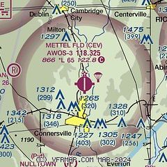
| Sectional chart |
|---|
|
| Airport distance calculator |
|---|
|
|
| Sunrise and sunset |
|---|
|
Times for 17-May-2026
| | Local
(UTC-4) | | Zulu
(UTC) |
|---|
| Morning civil twilight | | 05:55 | | 09:55 |
| Sunrise | | 06:25 | | 10:25 |
| Sunset | | 20:49 | | 00:49 |
| Evening civil twilight | | 21:19 | | 01:19 |
|
| Current date and time |
|---|
| Zulu (UTC) | 17-May-2026 15:12:55 |
|---|
| Local (UTC-4) | 17-May-2026 11:12:55 |
|---|
|
| METAR |
|---|
KRID
14nm E | 171455Z AUTO 20011KT 10SM CLR 23/17 A3008 RMK AO2
|
KUWL
14nm NW | 171455Z AUTO 21012G18KT 10SM CLR 24/18 A3005 RMK A01
|
KOXD
20nm SE | 171441Z AUTO 21010KT 10SM OVC038 23/18 A3009 RMK AO2
|
KHLB
22nm S | 171450Z AUTO VRB05G15KT 10SM CLR 24/18 A3007 RMK A01
|
|
| TAF |
|---|
KDAY
44nm E | 171120Z 1712/1812 19010KT P6SM SCT035 BKN120 FM171500 20012G20KT P6SM SCT050 FM180000 18006KT P6SM SCT250
|
KCVG
44nm SE | 171120Z 1712/1818 18008KT P6SM SCT120 FM171500 19010G18KT P6SM FEW050 FM180000 18006KT P6SM SCT250
|
KLUK
49nm SE | 171120Z 1712/1812 21004KT P6SM SCT120 TEMPO 1712/1713 5SM BR FM171600 19010G18KT P6SM FEW050 FM180000 18006KT P6SM SCT250 FM180800 00000KT 3SM BR SCT250
|
|
| NOTAMs |
|---|
NOTAMs are issued by the DoD/FAA and will open in a separate window not controlled by AirNav.
|
|

