FAA INFORMATION EFFECTIVE 09 JULY 2026
Location
| FAA Identifier: | LSN |
| Lat/Long: | 37-03-50.0000N 120-52-11.5000W
37-03.833333N 120-52.191667W
37.0638889,-120.8698611
(estimated) |
| Elevation: | 121.4 ft. / 37.0 m (surveyed) |
| Variation: | 16E (1980) |
| From city: | 1 mile W of LOS BANOS, CA |
| Time zone: | UTC -7 (UTC -8 during Standard Time) |
| Zip code: | 93635 |
Airport Operations
| Airport use: | Open to the public |
| Activation date: | 04/1940 |
| Control tower: | no |
| ARTCC: | OAKLAND CENTER |
| FSS: | RANCHO MURIETA FLIGHT SERVICE STATION |
| NOTAMs facility: | RIU (NOTAM-D service available) |
| Attendance: | UNATNDD |
| Pattern altitude: | 921.4 ft. MSL |
| Wind indicator: | lighted |
| Segmented circle: | yes |
| Lights: | MIRL RY 14/32 PRESET LOW INTST UNTIL 2400. TO INCR INTST AND ACTVT MIRL, REIL RY 14, RY 32 AND PAPI RY 14 AND RY 32 - CTAF. |
| Beacon: | white-green (lighted land airport)
Operates sunset to sunrise. |
Airport Communications
| CTAF/UNICOM: | 122.8 |
| WX AWOS-3: | 118.675 (209-827-7084) |
| NORCAL APPROACH: | 120.95 |
| NORCAL DEPARTURE: | 120.95 |
- COMMUNICATIONS PRVDD BY FRESNO RADIO ON FREQ 122.1R (PANOCHE RCO).
Nearby radio navigation aids
| VOR radial/distance | | VOR name | | Freq | | Var |
|---|
| PXNr332/21.4 | | PANOCHE VORTAC | | 112.60 | | 16E |
| HYPr232/24.3 | | EL NIDO VOR/DME | | 113.85 | | 15E |
| MODr156/34.1 | | MODESTO VOR/DME | | 114.60 | | 17E |
Airport Services
| Fuel available: | 100LL JET-A
100LL:24 HR AUTOMATED FUEL AVBL WITH MAJOR CREDIT CARD. CALL 209-827-7070 AFTER HRS FOR EMERG FULL SRV. |
| Parking: | tiedowns |
| Airframe service: | MINOR |
| Powerplant service: | MINOR |
| Bottled oxygen: | NONE |
| Bulk oxygen: | NONE |
Runway Information
Runway 14/32
| Dimensions: | 3801 x 75 ft. / 1159 x 23 m |
| Surface: | asphalt, in fair condition |
| Weight bearing capacity: | |
| Runway edge lights: | medium intensity |
| RUNWAY 14 | | RUNWAY 32 |
| Latitude: | 37-04.112515N | | 37-03.553248N |
| Longitude: | 120-52.367800W | | 120-52.016078W |
| Elevation: | 120.8 ft. | | 121.4 ft. |
| Traffic pattern: | right | | left |
| Runway heading: | 137 magnetic, 153 true | | 317 magnetic, 333 true |
| Markings: | basic, in fair condition | | basic, in fair condition |
| Visual slope indicator: | 2-light PAPI on left (3.00 degrees glide path) | | 2-light PAPI on left (3.00 degrees glide path) |
| Runway end identifier lights: | yes | | yes |
| Touchdown point: | yes, no lights | | yes, no lights |
| Obstructions: | 40 ft. pline, 1500 ft. from runway, 50 ft. left of centerline, 33:1 slope to clear | | 25 ft. tree, 760 ft. from runway, 25 ft. right of centerline, 21:1 slope to clear |
Airport Ownership and Management from official FAA records
| Ownership: | Publicly-owned |
| Owner: | CITY OF LOS BANOS
520 J STREET
LOS BANOS, CA 93635-4240
Phone 209-827-7034 |
| Manager: | MARC HEGUY
411 MADISON AVENUE
LOS BANOS, CA 93635-4214
Phone (209) 827-7056 |
Additional Remarks
| - | AVOID OVERFLIGHT OF HOUSES SOUTH OF ARPT. |
| - | NO DEPS OVER HOUSING AREAS TO EAST OF ARPT. |
| - | FOR CD CTC NORCAL APCH AT 916-361-0516. |
Instrument Procedures
NOTE: All procedures below are presented as PDF files. If you need a reader for these files, you should download the free Adobe Reader.NOT FOR NAVIGATION. Please procure official charts for flight.
FAA instrument procedures published for use from 09 July 2026 at 0901Z to 06 August 2026 at 0900Z.
IAPs - Instrument Approach Procedures |
|---|
| RNAV (GPS) RWY 14 | |
download (227KB) |
| RNAV (GPS) RWY 32 | |
download (212KB) |
| NOTE: Special Take-Off Minimums/Departure Procedures apply | |
download (128KB) |
Other nearby airports with instrument procedures:
KMCE - Merced Yosemite Regional Airport (22 nm NE)
F34 - Firebaugh Airport (23 nm SE)
KMER - Castle Airport (24 nm NE)
O15 - Turlock Municipal Airport (27 nm N)
KCVH - Hollister Municipal Airport (28 nm W)
|
|

Road maps at:
MapQuest
Bing
Google
| Aerial photo |
|---|
WARNING: Photo may not be current or correct
 Photo by Kedar S. Karmarkar
Taken mid June 2006
Photo by Kedar S. Karmarkar
Taken mid June 2006
Do you have a better or more recent aerial photo of Los Banos Municipal Airport that you would like to share? If so, please send us your photo.
|
| Sectional chart |
|---|
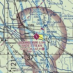
|
| Airport distance calculator |
|---|
|
|
| Sunrise and sunset |
|---|
|
Times for 22-Jul-2026
| | Local
(UTC-7) | | Zulu
(UTC) |
|---|
| Morning civil twilight | | 05:32 | | 12:32 |
| Sunrise | | 06:02 | | 13:02 |
| Sunset | | 20:18 | | 03:18 |
| Evening civil twilight | | 20:48 | | 03:48 |
|
| Current date and time |
|---|
| Zulu (UTC) | 22-Jul-2026 19:44:09 |
|---|
| Local (UTC-7) | 22-Jul-2026 12:44:09 |
|---|
|
| METAR |
|---|
KMCE
22nm NE | 221853Z AUTO 31010G17KT 10SM CLR 29/17 A3001 RMK AO2 SLP159 T02940167
|
KMER
24nm NE | 221755Z 32010KT 10SM CLR
|
KCVH
28nm W | 221935Z AUTO 29007G12KT 10SM FEW020 22/15 A3011 RMK A01
|
KMOD
33nm N | 221853Z 33010G17KT 10SM CLR 28/17 A3002 RMK AO2 SLP165 T02780167
|
KE16
35nm W | 221910Z AUTO 21012G16KT 10SM CLR 22/15 A3010 RMK AO2
|
KMAE
36nm E | 221855Z AUTO 33008KT 10SM CLR 31/17 A3002 RMK AO2 SLP159 T03060172 $
|
KSNS
42nm SW | 221933Z 32009KT 10SM OVC015 20/15 A3010 RMK AO2 T02000150
|
|
| TAF |
|---|
KMCE
22nm NE | 221720Z 2218/2318 29007KT P6SM SKC FM222200 32012KT P6SM SKC FM230100 33013G22KT P6SM SKC FM230900 33009KT P6SM SKC
|
|
| NOTAMs |
|---|
NOTAMs are issued by the DoD/FAA and will open in a separate window not controlled by AirNav.
|
|


