FAA INFORMATION EFFECTIVE 10 JULY 2025
Location
| FAA Identifier: | MAW |
| Lat/Long: | 36-35-53.5350N 089-59-33.1750W
36-35.892250N 089-59.552917W
36.5982042,-89.9925486
(estimated) |
| Elevation: | 295.3 ft. / 90.0 m (surveyed) |
| Variation: | 01W (2010) |
| From city: | 3 miles N of MALDEN, MO |
| Time zone: | UTC -5 (UTC -6 during Standard Time) |
| Zip code: | 63863 |
Airport Operations
| Airport use: | Open to the public |
| Activation date: | 05/1941 |
| Control tower: | no |
| ARTCC: | MEMPHIS CENTER |
| FSS: | SAINT LOUIS FLIGHT SERVICE STATION |
| NOTAMs facility: | STL (NOTAM-D service available) |
| Attendance: | MON-FRI 0800-1700 |
| Wind indicator: | lighted |
| Segmented circle: | yes |
| Lights: | ACTVT REIL RWY 14/32 & 18/36; PAPI RWY 18, 36 & 32; MIRL RWYS 14/32 & 18/36 - CTAF. |
| Beacon: | white-green (lighted land airport)
Operates sunset to sunrise. |
Airport Communications
| CTAF/UNICOM: | 122.8 |
| WX AWOS-3PT: | 119.825 (573-276-9970) |
| WX ASOS at POF (19 nm NW): | 124.225 (573-598-8719) |
- APCH/DEP SVC PRVDD BY MEMPHIS ARTCC ON FREQS 133.65/292.15 (PADUCAH RCAG).
Airport Services
| Fuel available: | 100LL JET-A1+
A1+:REGULAR AND AFTER HOURS, CALL IN ADVANCE FOR JET A1 573-776-4406 |
| Parking: | hangars and tiedowns |
| Airframe service: | MINOR |
| Powerplant service: | MINOR |
| Bottled oxygen: | NONE |
| Bulk oxygen: | NONE |
Runway Information
Runway 18/36
| Dimensions: | 5010 x 100 ft. / 1527 x 30 m |
| Surface: | asphalt, in good condition |
| Weight bearing capacity: | | Single wheel: | 33.0 | | Double wheel: | 48.0 |
|
| Runway edge lights: | medium intensity |
| RUNWAY 18 | | RUNWAY 36 |
| Latitude: | 36-36.446303N | | 36-35.620643N |
| Longitude: | 089-59.603057W | | 089-59.614113W |
| Elevation: | 294.6 ft. | | 292.1 ft. |
| Traffic pattern: | right | | left |
| Runway heading: | 182 magnetic, 181 true | | 002 magnetic, 001 true |
| Markings: | nonprecision, in fair condition | | nonprecision, in fair condition |
| Visual slope indicator: | 4-light PAPI on left (3.00 degrees glide path) | | 4-light PAPI on right (3.00 degrees glide path) |
| Runway end identifier lights: | yes | | yes |
| Touchdown point: | yes, no lights | | yes, no lights |
Runway 14/32
| Dimensions: | 5001 x 80 ft. / 1524 x 24 m |
| Surface: | asphalt, in fair condition |
| Weight bearing capacity: | | Single wheel: | 33.0 | | Double wheel: | 48.0 |
|
| Runway edge lights: | medium intensity |
| RUNWAY 14 | | RUNWAY 32 |
| Latitude: | 36-36.045358N | | 36-35.456088N |
| Longitude: | 089-59.854390W | | 089-59.139960W |
| Elevation: | 292.9 ft. | | 291.2 ft. |
| Traffic pattern: | right | | left |
| Runway heading: | 137 magnetic, 136 true | | 317 magnetic, 316 true |
| Markings: | nonprecision, in good condition | | nonprecision, in good condition |
| Visual slope indicator: | | | 4-light PAPI on right (3.00 degrees glide path) |
| Runway end identifier lights: | yes | | yes
REIL OTS INDEFINITELY. |
| Touchdown point: | yes, no lights | | yes, no lights |
Airport Ownership and Management from official FAA records
| Ownership: | Publicly-owned |
| Owner: | CITY OF MALDEN
201 S. MADISON
MALDEN, MO 63863
Phone 573-276-4502 |
| Manager: | DAVID BLALOCK
PO BOX 411
MALDEN, MO 63863
Phone 573-276-2279
FBO PHONE (573)-776-4406 EMERGENCY CONTACT (573)-281-0059 |
Additional Remarks
| - | CROP DUSTING ACFT ON & INVOF ARPT. |
| - | FOR CD IF UNA VIA GCO CTC MEMPHIS ARTCC AT 901-368-8453/8449. |
| - | IRRIGATION SYSTEM MAY BE OPERATING WITHIN 300 FT OF RY 18 AND RY 32 ENDS AND SIDES. |
| - | A/G TEST FLYING. |
| - | 24 HR ACCESS TO PILOTS LOUNGE. ENTER UNICOM ON LOCK FOR ACCESS. |
| - | GCO AVBL ON FREQ 135.075 4 CLICKS TO MEMPHIS CENTER AND 6 CLICKS TO FSS . |
| - | PERM AEROBATIC PRACTICE BOX SFC - 5,000 FT, WEST OF RWYS. |
Instrument Procedures
NOTE: All procedures below are presented as PDF files. If you need a reader for these files, you should download the free Adobe Reader.NOT FOR NAVIGATION. Please procure official charts for flight.
FAA instrument procedures published for use from 10 July 2025 at 0901Z to 07 August 2025 at 0900z.
IAPs - Instrument Approach Procedures |
|---|
| RNAV (GPS) RWY 14 | |
download (185KB) |
| RNAV (GPS) RWY 18 | |
download (207KB) |
| RNAV (GPS) RWY 32 | |
download (189KB) |
| RNAV (GPS) RWY 36 | |
download (208KB) |
| NOTE: Special Alternate Minimums apply | |
download (124KB) |
| NOTE: Special Take-Off Minimums/Departure Procedures apply | |
download (158KB) |
Other nearby airports with instrument procedures:
M85 - Gideon Memorial Airport (10 nm SE)
KDXE - Dexter Municipal Airport (11 nm N)
KPOF - Poplar Bluff Regional Business Airport (19 nm NW)
KEIW - County Memorial Airport (19 nm E)
KTKX - Kennett Memorial Airport (22 nm S)
|
|

Road maps at:
MapQuest
Bing
Google
| Aerial photo |
|---|
WARNING: Photo may not be current or correct
 looking north.
Do you have a better or more recent aerial photo of Malden Regional Airport that you would like to share? If so, please send us your photo.
|
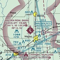
| Sectional chart |
|---|
|
| Airport distance calculator |
|---|
|
|
| Sunrise and sunset |
|---|
|
Times for 14-Jul-2025
| | Local
(UTC-5) | | Zulu
(UTC) |
|---|
| Morning civil twilight | | 05:24 | | 10:24 |
| Sunrise | | 05:53 | | 10:53 |
| Sunset | | 20:18 | | 01:18 |
| Evening civil twilight | | 20:48 | | 01:48 |
|
| Current date and time |
|---|
| Zulu (UTC) | 14-Jul-2025 23:59:15 |
|---|
| Local (UTC-5) | 14-Jul-2025 18:59:15 |
|---|
|
| METAR |
|---|
| KMAW | 142355Z AUTO 20005KT 10SM CLR 29/23 A3002 RMK AO1
|
KPOF
19nm NW | 142353Z AUTO 00000KT 10SM VCTS CLR 28/23 A3001 RMK AO2 LTG DSNT NW SLP157 60000 T02780233 10306 20278 53002
|
|
| TAF |
|---|
KCGI
43nm NE | 141750Z 1418/1518 15005KT P6SM SCT030 BKN050 PROB30 1419/1423 4SM TSRA BKN025CB FM150000 18004KT P6SM BKN080 FM150800 00000KT 5SM BR BKN026 FM151400 20007KT P6SM BKN028
|
|
| NOTAMs |
|---|
NOTAMs are issued by the DoD/FAA and will open in a separate window not controlled by AirNav.
|
|


