FAA INFORMATION EFFECTIVE 16 APRIL 2026
Location
| FAA Identifier: | N43 |
| Lat/Long: | 40-44-31.8000N 075-14-34.6000W
40-44.530000N 075-14.576667W
40.7421667,-75.2429444
(estimated) |
| Elevation: | 396.8 ft. / 120.9 m (surveyed) |
| Variation: | 13W (2000) |
| From city: | 3 miles N of EASTON, PA |
| Time zone: | UTC -4 (UTC -5 during Standard Time) |
| Zip code: | 18040 |
Airport Operations
| Airport use: | Open to the public |
| Activation date: | 10/1937 |
| Control tower: | no |
| ARTCC: | NEW YORK CENTER |
| FSS: | WILLIAMSPORT FLIGHT SERVICE STATION |
| NOTAMs facility: | IPT (NOTAM-D service available) |
| Attendance: | 0800-1630 |
| Wind indicator: | lighted |
| Segmented circle: | no |
| Beacon: | white-green (lighted land airport)
Operates sunset to sunrise. |
Airport Communications
| CTAF/UNICOM: | 123.0 |
| ALLENTOWN APPROACH: | 119.65 ;3000 FT & BLW 124.45 ;ABV 3000 FT |
| ALLENTOWN DEPARTURE: | 119.65 ;3000 FT & BLW 124.45 ;ABV 3000 FT |
| IC: | 119.65 ;3000 FT & BLW 124.45 ;ABV 3000 FT |
| WX ASOS at ABE (10 nm SW): | 126.975 (610-477-0813) |
| WX AWOS-3 at XLL (15 nm SW): | 127.875 (610-231-3111) |
| WX AWOS-3 at N40 (16 nm SE): | 121.725 |
| WX AWOS-3 at UKT (19 nm S): | 119.475 (215-538-7610) |
Nearby radio navigation aids
| VOR radial/distance | | VOR name | | Freq | | Var |
|---|
| FJCr094/9.7 | | ALLENTOWN VORTAC | | 117.50 | | 10W |
| BWZr271/19.4 | | BROADWAY VOR/DME | | 114.20 | | 11W |
| ETXr073/22.3 | | EAST TEXAS VOR/DME | | 110.20 | | 09W |
| STWr239/22.8 | | STILLWATER VOR/DME | | 109.60 | | 11W |
| SBJr303/24.7 | | SOLBERG VOR/DME | | 112.90 | | 10W |
| ARDr342/33.1 | | YARDLEY VOR/DME | | 108.20 | | 10W |
| PTWr034/34.4 | | POTTSTOWN VORTAC | | 116.50 | | 09W |
| SAXr250/37.4 | | SPARTA VORTAC | | 115.70 | | 11W |
| LVZr158/37.7 | | WILKES-BARRE VORTAC | | 111.60 | | 10W |
Airport Services
| Fuel available: | 100LL
100LL:24 HR SELF-SERVE FUEL AVAILABLE. |
| Parking: | hangars and tiedowns |
| Airframe service: | MINOR |
| Powerplant service: | MINOR |
| Bottled oxygen: | NONE |
| Bulk oxygen: | NONE |
Runway Information
Runway 18/36
| Dimensions: | 1956 x 165 ft. / 596 x 50 m
RY 18/36 1956 FT BY 50 FT ASPH ALIGNED IN CNTR OF 165 FT TURF STRIP. |
| Surface: | asphalt/turf, in good condition |
| Runway edge lights: | non-standard
RWY 18/36 NSTD LIRL LGTS SPCD AT 400 FT INTERVALS. |
| RUNWAY 18 | | RUNWAY 36 |
| Latitude: | 40-44.685712N | | 40-44.373165N |
| Longitude: | 075-14.627860W | | 075-14.525230W |
| Elevation: | 394.6 ft. | | 384.3 ft. |
| Traffic pattern: | left | | left |
| Runway heading: | 179 magnetic, 166 true | | 359 magnetic, 346 true |
| Displaced threshold: | 192 ft. | | no |
| Markings: | basic, in good condition | | nonprecision, in good condition |
| Touchdown point: | yes, no lights | | yes, no lights |
| Obstructions: | 26 ft. trees, 415 ft. from runway, 221 ft. left of centerline, 8:1 slope to clear
APCH RATIO 22:1 TO DTHR. | | 28 ft. trees, 685 ft. from runway, 121 ft. right of centerline, 17:1 slope to clear |
Airport Ownership and Management from official FAA records
| Ownership: | Publicly-owned |
| Owner: | LEHIGH-NORTHAMPTON ARPT AUTHORITY
LEHIGH VALLEY INTL ARPT, 3311 AIRPORT ROAD
ALLENTOWN, PA 18109-3040
Phone 610-266-6001 |
| Manager: | THOMAS R. STOUDT
BRADEN AIRPARK, 3800 SULLIVAN TRAIL
EASTON, PA 18040
Phone 610-231-5270 |
Additional Remarks
| - | ACFT MAY NOT BE VISIBLE ON ALL PARTS OF FIELD. |
| - | FOR CD CTC ALLENTOWN APCH AT 800-728-6322. |
Instrument Procedures
NOTE: All procedures below are presented as PDF files. If you need a reader for these files, you should download the free Adobe Reader.NOT FOR NAVIGATION. Please procure official charts for flight.
FAA instrument procedures published for use from 16 April 2026 at 0901Z to 14 May 2026 at 0900Z.
IAPs - Instrument Approach Procedures |
|---|
| RNAV (GPS)-A | |
download (189KB) |
| NOTE: Special Take-Off Minimums/Departure Procedures apply | |
download (149KB) |
Other nearby airports with instrument procedures:
KABE - Lehigh Valley International Airport (10 nm SW)
N85 - Alexandria Airport (14 nm SE)
KXLL - Allentown Queen City Municipal Airport (15 nm SW)
N40 - Sky Manor Airport (16 nm SE)
1N7 - Blairstown Airport (18 nm NE)
KUKT - Quakertown Airport (19 nm S)
|
|

Road maps at:
MapQuest
Bing
Google
| Aerial photo |
|---|
WARNING: Photo may not be current or correct
 Photo courtesy of EagleView Reveal Imagery
Taken in 2019
looking north.
Photo courtesy of EagleView Reveal Imagery
Taken in 2019
looking north.
Do you have a better or more recent aerial photo of Braden Airpark that you would like to share? If so, please send us your photo.
|
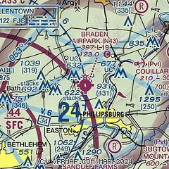
| Sectional chart |
|---|
|
| Airport distance calculator |
|---|
|
|
| Sunrise and sunset |
|---|
|
Times for 08-May-2026
| | Local
(UTC-4) | | Zulu
(UTC) |
|---|
| Morning civil twilight | | 05:22 | | 09:22 |
| Sunrise | | 05:52 | | 09:52 |
| Sunset | | 20:03 | | 00:03 |
| Evening civil twilight | | 20:33 | | 00:33 |
|
| Current date and time |
|---|
| Zulu (UTC) | 09-May-2026 03:20:39 |
|---|
| Local (UTC-4) | 08-May-2026 23:20:39 |
|---|
|
| METAR |
|---|
KABE
11nm SW | 090251Z 00000KT 10SM CLR 13/06 A2991 RMK AO2 SLP127 T01330056 51017
|
KXLL
15nm SW | 090255Z AUTO 00000KT 10SM BKN110 13/06 A2992 RMK AO2 TSNO
|
KUKT
19nm S | 090255Z AUTO 00000KT 10SM BKN120 12/09 A2991 RMK AO2
|
KCKZ
21nm S | 090255Z AUTO 00000KT 10SM SCT075 BKN090 BKN110 11/08 A2992 RMK AO2
|
|
| TAF |
|---|
KABE
11nm SW | 081859Z 0819/0918 28015G28KT P6SM VCSH SCT040 BKN100 FM082300 VRB03KT P6SM BKN070 FM091200 17005KT P6SM VCSH BKN050 OVC100 FM091500 20010KT 5SM SHRA BR OVC025
|
|
| NOTAMs |
|---|
NOTAMs are issued by the DoD/FAA and will open in a separate window not controlled by AirNav.
|
|


