FAA INFORMATION EFFECTIVE 25 DECEMBER 2025
Location
| FAA Identifier: | PNE |
| Lat/Long: | 40-04-54.9780N 075-00-38.0800W
40-04.916300N 075-00.634667W
40.0819383,-75.0105778
(estimated) |
| Elevation: | 119.8 ft. / 36.5 m (surveyed) |
| Variation: | 12W (2005) |
| From city: | 10 miles NE of PHILADELPHIA, PA |
| Time zone: | UTC -5 (UTC -4 during Daylight Saving Time) |
| Zip code: | 19114 |
Airport Operations
| Airport use: | Open to the public |
| Activation date: | 07/1938 |
| Control tower: | yes |
| ARTCC: | NEW YORK CENTER |
| FSS: | WILLIAMSPORT FLIGHT SERVICE STATION |
| NOTAMs facility: | PNE (NOTAM-D service available) |
| Attendance: | CONTINUOUS |
| Wind indicator: | lighted |
| Segmented circle: | no |
| Lights: | WHEN ATCT CLSD HIRL RWY 06/24 PRESET MED INTST, TO INCRS INTST AND ACTVT MALSR RWY 24 - CTAF |
| Beacon: | white-green (lighted land airport)
Operates sunset to sunrise. |
| Landing fee: | yes |
| International operations: | customs landing rights airport
CBP 24 HR PPR BY CALLING (215) 594-4272 OR (215)
594-4141. |
Airport Communications
| CTAF: | 126.9 |
| UNICOM: | 122.95 |
| ATIS: | 121.15 |
| WX ASOS: | PHONE 215-897-9068 |
| NORTHEAST PHILADELPHIA GROUND: | 121.7 [0600-2300] |
| NORTHEAST PHILADELPHIA TOWER: | 126.9 278.8 [0600-2300] |
| PHILADELPHIA APPROACH: | 123.8 |
| PHILADELPHIA DEPARTURE: | 123.8 |
| CLEARANCE DELIVERY: | 127.25 |
| WX ASOS at VAY (11 nm SE): | 119.325 (609-267-1176) |
| WX AWOS-3 at LOM (12 nm W): | 118.925 (215-646-1068) |
| WX ASOS at TTN (15 nm NE): | 126.775 (609-538-8690) |
| WX ASOS at DYL (16 nm N): | 118.875 (215-345-0392) |
| WX ASOS at PHL (16 nm SW): | 133.4 (215-492-9617) |
- CLEARANCE DELIVERY PHILADELPHIA APCH TF 800-354-9884.
- EMERG FREQ 121.5 NOT AVAILABLE AT TOWER.
Nearby radio navigation aids
| VOR radial/distance | | VOR name | | Freq | | Var |
|---|
| ARDr215/11.3 | | YARDLEY VOR/DME | | 108.20 | | 10W |
| GXUr295/19.5 | | MC GUIRE VORTAC | | 110.60 | | 12W |
| RBVr263/24.7 | | ROBBINSVILLE VORTAC | | 113.80 | | 10W |
| PTWr117/26.6 | | POTTSTOWN VORTAC | | 116.50 | | 09W |
| OODr037/30.0 | | WOODSTOWN VORTAC | | 112.80 | | 10W |
| CYNr311/31.0 | | COYLE VORTAC | | 113.40 | | 10W |
| MXEr081/31.9 | | MODENA VORTAC | | 113.20 | | 09W |
| SBJr212/32.5 | | SOLBERG VOR/DME | | 112.90 | | 10W |
| VCNr006/32.7 | | CEDAR LAKE VOR/DME | | 115.20 | | 10W |
| DQOr059/36.6 | | DUPONT VORTAC | | 114.00 | | 10W |
| NDB name | | Hdg/Dist | | Freq | | Var | | ID |
|---|
| LAKEHURST | | 285/31.1 | | 396 | | 11W | | NEL | -. . .-.. |
Airport Services
| Fuel available: | 100LL JET-A |
| Parking: | hangars and tiedowns |
| Airframe service: | MAJOR |
| Powerplant service: | MAJOR |
| Bottled oxygen: | HIGH/LOW |
| Bulk oxygen: | HIGH |
Runway Information
Runway 6/24
| Dimensions: | 7000 x 100 ft. / 2134 x 30 m |
| Surface: | asphalt/grooved, in good condition |
| Weight bearing capacity: | | PCN 80 /F/A/X/T | | Single wheel: | 120.0 | | Double wheel: | 250.0 | | Double tandem: | 550.0 |
|
| Runway edge lights: | high intensity |
| RUNWAY 6 | | RUNWAY 24 |
| Latitude: | 40-04.650320N | | 40-05.415597N |
| Longitude: | 075-01.215512W | | 075-00.093015W |
| Elevation: | 116.7 ft. | | 113.7 ft. |
| Traffic pattern: | left | | left |
| Runway heading: | 060 magnetic, 048 true | | 240 magnetic, 228 true |
| Displaced threshold: | 498 ft. | | no |
| Declared distances: | TORA:7000 TODA:7000 ASDA:7000 LDA:6502 | | TORA:6826 TODA:7000 ASDA:6102 LDA:6102 |
| Markings: | precision, in good condition | | precision, in good condition |
| Visual slope indicator: | 4-light PAPI on left (3.00 degrees glide path) | | 4-light PAPI on right (3.00 degrees glide path) |
| Approach lights: | | | MALSR: 1,400 foot medium intensity approach lighting system with runway alignment indicator lights |
| Runway end identifier lights: | yes | | |
| Touchdown point: | yes, no lights | | yes, no lights |
| Instrument approach: | | | ILS |
| Obstructions: | 59 ft. trees, 1524 ft. from runway, 372 ft. left of centerline, 22:1 slope to clear | | 68 ft. trees, 2273 ft. from runway, 769 ft. right of centerline, 30:1 slope to clear |
Runway 15/33
| Dimensions: | 4999 x 150 ft. / 1524 x 46 m |
| Surface: | asphalt/grooved, in good condition |
| Weight bearing capacity: | | Single wheel: | 40.0 | | Double wheel: | 55.0 |
|
| Runway edge lights: | medium intensity |
| RUNWAY 15 | | RUNWAY 33 |
| Latitude: | 40-05.071500N | | 40-04.434360N |
| Longitude: | 075-00.946680W | | 075-00.267660W |
| Elevation: | 119.8 ft. | | 107.9 ft. |
| Traffic pattern: | left | | left |
| Runway heading: | 153 magnetic, 141 true | | 333 magnetic, 321 true |
| Markings: | nonprecision, in good condition | | nonprecision, in good condition |
| Visual slope indicator: | 4-light PAPI on left (3.00 degrees glide path) | | 4-light PAPI on left (3.00 degrees glide path) |
| Runway end identifier lights: | yes | | yes |
| Touchdown point: | yes, no lights | | yes, no lights |
| Obstructions: | 41 ft. tree, 1023 ft. from runway, 4 ft. left of centerline, 20:1 slope to clear | | 44 ft. tree, 1472 ft. from runway, 296 ft. right of centerline, 28:1 slope to clear |
Airport Ownership and Management from official FAA records
| Ownership: | Publicly-owned |
| Owner: | CITY OF PHILADELPHIA
PHILADELPHIA INT ARPT
PHILADELPHIA, PA 19153
Phone 215-937-6800 |
| Manager: | JOHN BREWER
9800 ASHTON ROAD
PHILADELPHIA, PA 19114
Phone 215-937-7968 |
Additional Remarks
| - | TURBOJET ACFT ARE CONFINED TO FULL LENGTH RWY 6/24 UNLESS STRONG WINDS DICTATE OTHERWISE. |
| - | BE ALERT: 3 LARGE BRIGHTLY LIT JUMBOTRON SIGNS APRX 3 MILES NE OF AER 24. THESE SIGNS MAY CAUSE VISUAL ILLUSIONS DURING AN APCH OR MISSED APCH. PILOTS BE AT ADVISED. |
| - | FOR CD WHEN ATCT IS CLSD CTC PHL APCH AT (800) 354-9884. |
| - | TWY L3 SAFETY AREA NON STD. |
| - | TWY J1 NON MOVEMENT AREA. |
| - | COMPASS ROSE NOT FOR PUB USE. |
| - | TWY J BTN TWY G AND HEL APN IS NON MOV AREA. |
| - | LMT TGL OPNS TO 0900-2200 MON-SAT AND 1200-2200 SUN; 5 PER FLT FOR NOISE ABATEMENT. |
| - | RWY 15 IS NOISE SENSITIVE. RWY 15 ARRIVALS ARE REQUESTED TO FLY AT OR ABOVE GLIDE PATH. |
| - | ARPT CLSD TO PART 121 AIR CARRIER AND PART 135 SCHEDULED SVC. |
| - | DEER & BIRDS ON & INVOF ARPT. |
| - | TPA ACFT LESS THAN 12500 LBS 1120 MSL; ACFT 12500 LBS OR MORE & ALL TURBOJET & TURBINE PWRD ACFT 1620 MSL; ROTARY WING ACFT 920 MSL. |
| - | BE ALERT FOR ARPT VEHICLES WHEN TWR CLSD. |
Instrument Procedures
NOTE: All procedures below are presented as PDF files. If you need a reader for these files, you should download the free Adobe Reader.NOT FOR NAVIGATION. Please procure official charts for flight.
FAA instrument procedures published for use from 25 December 2025 at 0901z to 22 January 2026 at 0900z.
STARs - Standard Terminal Arrivals |
|---|
| BUNTS THREE | |
download (154KB) |
| JIIMS FOUR (RNAV) | |
download (351KB) |
| PAATS FOUR (RNAV) | |
2 pages:
[1] [2] (487KB) |
IAPs - Instrument Approach Procedures |
|---|
| ILS OR LOC RWY 24 | |
download (238KB) |
| RNAV (GPS) RWY 06 | |
download (201KB) |
| RNAV (GPS) RWY 15 | |
download (218KB) |
| RNAV (GPS) RWY 24 | |
download (240KB) |
| RNAV (GPS) RWY 33 | |
download (267KB) |
| NOTE: Special Alternate Minimums apply | |
download (123KB) |
| NOTE: Special Take-Off Minimums/Departure Procedures apply | |
download (435KB) |
Other nearby airports with instrument procedures:
KVAY - South Jersey Regional Airport (11 nm SE)
KLOM - Wings Field Airport (12 nm W)
N14 - Flying W Airport (13 nm SE)
KTTN - Trenton Mercer Airport (15 nm NE)
KDYL - Doylestown Airport (16 nm N)
KPHL - Philadelphia International Airport (16 nm SW)
19N - Pine Valley Airport (18 nm S)
KWRI - McGuire Field (Joint Base Mc Guire Dix Lakehurst) Airport (20 nm E)
|
|

Road maps at:
MapQuest
Bing
Google
| Aerial photo |
|---|
WARNING: Photo may not be current or correct
 Photo taken 09-Nov-2019
looking northwest.
Photo taken 09-Nov-2019
looking northwest.
Do you have a better or more recent aerial photo of Northeast Philadelphia Airport that you would like to share? If so, please send us your photo.
|
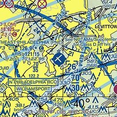
| Sectional chart |
|---|
|
 Download PDF
of official airport diagram from the FAA
| Airport distance calculator |
|---|
|
|
| Sunrise and sunset |
|---|
|
Times for 07-Jan-2026
| | Local
(UTC-5) | | Zulu
(UTC) |
|---|
| Morning civil twilight | | 06:53 | | 11:53 |
| Sunrise | | 07:23 | | 12:23 |
| Sunset | | 16:49 | | 21:49 |
| Evening civil twilight | | 17:20 | | 22:20 |
|
| Current date and time |
|---|
| Zulu (UTC) | 08-Jan-2026 03:28:24 |
|---|
| Local (UTC-5) | 07-Jan-2026 22:28:24 |
|---|
|
| METAR |
|---|
| KPNE | 080254Z 28003KT 10SM FEW040 08/02 A3002 RMK AO2 SLP167 T00780022 53023
|
KVAY
12nm SE | ASOS 119.325 609-267-1176
080254Z AUTO 00000KT 10SM CLR 08/02 A3001 RMK AO2 SLP163 T00780022 51023 $
|
KLOM
12nm W | 080315Z AUTO 29003KT 10SM SCT031 06/02 A3001 RMK AO2 T00620020
|
KTTN
15nm NE | ASOS 133.70 609-538-8690
080253Z 29004KT 10SM OVC033 08/02 A3000 RMK AO2 SLP153 T00780022 53023 $
|
KDYL
16nm N | 080254Z AUTO 31005KT 10SM OVC031 08/02 A2999 RMK AO2 SLP158 T00830017 51016 $
|
KPHL
16nm SW | 080254Z 32005KT 10SM FEW045 SCT240 09/03 A3002 RMK AO2 SLP164 T00890033 51022
|
|
| TAF |
|---|
| KPNE | 072031Z 0721/0818 30010G18KT P6SM BKN040 FM072200 29008KT P6SM FEW060 FM080600 VRB03KT P6SM FEW100
|
KTTN
15nm NE | 071721Z 0718/0818 29012G21KT P6SM SCT040 FM072200 29007KT P6SM FEW060 FM080600 VRB03KT P6SM FEW100
|
KPHL
16nm SW | 072031Z 0721/0824 30010G18KT P6SM BKN040 FM072200 29008KT P6SM FEW060 FM080600 29003KT P6SM FEW100 FM081700 30004KT P6SM FEW250 FM082000 26004KT P6SM FEW250
|
|
| NOTAMs |
|---|
NOTAMs are issued by the DoD/FAA and will open in a separate window not controlled by AirNav.
|
|


