FAA INFORMATION EFFECTIVE 19 FEBRUARY 2026
Location
| FAA Identifier: | SDF |
| Lat/Long: | 38-10-26.7060N 085-44-11.3770W
38-10.445100N 085-44.189617W
38.1740850,-85.7364936
(estimated) |
| Elevation: | 500.8 ft. / 152.6 m (surveyed) |
| Variation: | 05W (2020) |
| From city: | 4 miles S of LOUISVILLE, KY |
| Time zone: | UTC -5 (UTC -4 during Daylight Saving Time) |
| Zip code: | 40213 |
Airport Operations
| Airport use: | Open to the public |
| Activation date: | 11/1942 |
| Control tower: | yes |
| ARTCC: | INDIANAPOLIS CENTER |
| FSS: | LOUISVILLE FLIGHT SERVICE STATION |
| NOTAMs facility: | SDF (NOTAM-D service available) |
| Attendance: | CONTINUOUS |
| Wind indicator: | lighted |
| Segmented circle: | no |
| Beacon: | white-green (lighted land airport)
Operates sunset to sunrise. |
| Fire and rescue: | ARFF index C |
| International operations: | customs landing rights airport |
Airport Communications
| UNICOM: | 122.95 |
| WX ASOS: | PHONE 502-676-6814 |
| LOUISVILLE GROUND: | 121.7 348.6 |
| LOUISVILLE TOWER: | 124.2 257.8 |
| LOUISVILLE APPROACH: | 123.675 ;170-349 132.075 ;350-169 132.075 134.15 327.0 |
| LOUISVILLE DEPARTURE: | 123.675 ;170-349 132.075 ;350-169 132.075 327.0 |
| CLEARANCE DELIVERY: | 126.1 275.8 |
| ANG OPS: | 268.1 |
| CLASS C: | 123.675 ;170-349 132.075 ;350-169 327.0 |
| D-ATIS: | 118.725 |
| EMERG: | 121.5 243.0 |
| IC: | 132.075 |
| WX ASOS at LOU (5 nm NE): | PHONE 502-473-0693 |
| WX AWOS-3 at JVY (12 nm N): | 118.575 (812-246-1278) |
- ASDE-X IN USE. OPERATE TRANSPONDERS WITH ALTITUDE REPORTING MODE AND ADS-B (IF EQUIPPED) ENABLED ON ALL AIRPORT SURFACES.
Nearby radio navigation aids
| VOR radial/distance | | VOR name | | Freq | | Var |
|---|
| IIUr298/8.6 | | LOUISVILLE VORTAC | | 114.80 | | 01E |
| FTKr036/19.5 | | FORT KNOX VOR/DME | | 109.60 | | 01W |
| MYSr056/(29.3) | | MYSTIC VOR | | 108.20 | | 01W |
| EWOr354/32.7 | | NEW HOPE VOR/DME | | 113.95 | | 01E |
| FFTr272/(39.0) | | FRANKFORT VOR | | 109.40 | | 03W |
| NDB name | | Hdg/Dist | | Freq | | Var | | ID |
|---|
| LAANG | | 294/5.2 | | 414 | | 04W | | LK | .-.. -.- |
| GODMAN | | 044/17.2 | | 396 | | 03W | | GOI | --. --- .. |
Airport Services
| Fuel available: | 100LL JET-A JET-A+ |
| Parking: | hangars and tiedowns |
| Airframe service: | MAJOR |
| Powerplant service: | MAJOR |
| Bottled oxygen: | LOW |
| Bulk oxygen: | NONE |
Runway Information
Runway 17R/35L
| Dimensions: | 11887 x 150 ft. / 3623 x 46 m |
| Surface: | concrete/grooved, in good condition |
| Weight bearing capacity: | | Single wheel: | 75.0 | | Double wheel: | 207.0 | | Double tandem: | 360.0 | | Dual double tandem: | 850.0 |
|
| Runway edge lights: | high intensity |
| RUNWAY 17R | | RUNWAY 35L |
| Latitude: | 38-11.219277N | | 38-09.324158N |
| Longitude: | 085-44.926775W | | 085-44.301480W |
| Elevation: | 489.3 ft. | | 461.3 ft. |
| Traffic pattern: | left | | left |
| Runway heading: | 170 magnetic, 165 true | | 350 magnetic, 345 true |
| Displaced threshold: | 846 ft. | | 1040 ft. |
| Declared distances: | TORA:11095 TODA:11095 ASDA:11095 LDA:10000 | | TORA:11290 TODA:11290 ASDA:11290 LDA:10000 |
| Markings: | precision, in good condition | | precision, in good condition |
| Visual slope indicator: | 4-light PAPI on right (3.00 degrees glide path) | | 4-light PAPI on left (3.00 degrees glide path) |
| RVR equipment: | touchdown, midfield, rollout | | touchdown, midfield, rollout |
| Approach lights: | MALSR: 1,400 foot medium intensity approach lighting system with runway alignment indicator lights | | ALSF2: standard 2,400 foot high intensity approach lighting system with centerline sequenced flashers (category II or III) |
| Centerline lights: | yes | | yes |
| Touchdown point: | yes, lighted | | yes, lighted |
| Instrument approach: | ILS/DME | | ILS/DME |
Runway 17L/35R
| Dimensions: | 8578 x 150 ft. / 2615 x 46 m |
| Surface: | concrete/grooved, in good condition |
| Weight bearing capacity: | | Single wheel: | 75.0 | | Double wheel: | 207.0 | | Double tandem: | 360.0 | | Dual double tandem: | 850.0 |
|
| Runway edge lights: | high intensity |
| RUNWAY 17L | | RUNWAY 35R |
| Latitude: | 38-11.237940N | | 38-09.873360N |
| Longitude: | 085-43.880507W | | 085-43.414490W |
| Elevation: | 500.8 ft. | | 471.3 ft. |
| Traffic pattern: | left | | left |
| Runway heading: | 170 magnetic, 165 true | | 350 magnetic, 345 true |
| Displaced threshold: | 328 ft. | | 449 ft. |
| Declared distances: | TORA:8579 TODA:8579 ASDA:8129 LDA:7800 | | TORA:8579 TODA:8579 ASDA:8250 LDA:7800 |
| Markings: | precision, in good condition | | precision, in good condition |
| Visual slope indicator: | 4-light PAPI on left (3.00 degrees glide path) | | 4-light PAPI on right (3.00 degrees glide path) |
| RVR equipment: | touchdown, midfield, rollout | | touchdown, midfield, rollout |
| Approach lights: | MALSR: 1,400 foot medium intensity approach lighting system with runway alignment indicator lights | | ALSF2: standard 2,400 foot high intensity approach lighting system with centerline sequenced flashers (category II or III) |
| Centerline lights: | yes | | yes |
| Touchdown point: | yes, lighted | | yes, lighted |
| Instrument approach: | ILS/DME | | ILS/DME |
Runway 11/29
| Dimensions: | 7251 x 150 ft. / 2210 x 46 m |
| Surface: | concrete/wired/combed, in good condition |
| Weight bearing capacity: | | Single wheel: | 75.0 | | Double wheel: | 170.0 | | Double tandem: | 360.0 | | Dual double tandem: | 850.0 |
|
| Runway edge lights: | high intensity |
| RUNWAY 11 | | RUNWAY 29 |
| Latitude: | 38-10.813640N | | 38-10.383263N |
| Longitude: | 085-44.841032W | | 085-43.429383W |
| Elevation: | 476.5 ft. | | 480.0 ft. |
| Traffic pattern: | left | | left |
| Runway heading: | 116 magnetic, 111 true | | 296 magnetic, 291 true |
| Declared distances: | TORA:7250 TODA:7250 ASDA:6946 LDA:6946 | | TORA:7250 TODA:7250 ASDA:7250 LDA:7250 |
| Markings: | basic, in good condition | | precision, in good condition |
| Visual slope indicator: | 4-light PAPI on left (3.00 degrees glide path) | | 4-light PAPI on left (3.00 degrees glide path) |
| RVR equipment: | rollout | | touchdown |
| Approach lights: | | | MALSR: 1,400 foot medium intensity approach lighting system with runway alignment indicator lights |
| Touchdown point: | yes, no lights | | yes, no lights |
| Instrument approach: | | | LOCALIZER |
| Obstructions: | 55 ft. bldg, 1375 ft. from runway, 325 ft. right of centerline, 20:1 slope to clear | | none |
Airport Ownership and Management from official FAA records
| Ownership: | Publicly-owned |
| Owner: | LOUISVILLE REGIONAL ARPT AUTH
700 ADMINISTRATION DRIVE
LOUISVILLE, KY 40209
Phone 502-380-8200 |
| Manager: | DAN MANN
700 ADMINISTRATION DRIVE
LOUISVILLE, KY 40209
Phone 502-380-8200 |
Additional Remarks
| A39-11/29 | PCR VALUE: 720/R/B/W/T |
| A39-17L/35R | PCR VALUE: 970/R/B/W/T |
| A39-17R/35L | PCR VALUE: 770/R/A/W/T |
| A30A-17R | STD DEP POINTS AT TWY B8 & TWY A8. REQS USE OF RWY 17R EXTN. TKOF AT TWY B8 ASDA/TORA/TODA 10245 FT. |
| A30A-35R | TWY E2 INTXN DEP 6300 FT AVBL. |
| A30A-35L | STD DEP POINTS AT TWY A & TWY B; REQS USE OF RWY 35L EXTN; TKOF AT TWY A & TWY B ASDA/TORA/TODA 10250 FT. |
| A30A-17L | TWY E INTXN DEP 7700 FT AVBL. |
| - | BIRDS ON & INVOF ARPT. |
| - | TAIL HGT 65 FT OR GTR 24 HR PPR. |
| - | ANG: FAA GP 6 ACFT 24 HR PPR. |
| - | CTN: CONST IN PROG; FQT RWY & TWY CLOSURES PSBL. |
| - | ANG/123TAC RECON. |
| - | LINE UP & WAIT WAIVER IN EFCT SS-SR AT INT OF RWY 17R AT TWY B8 OR AT TWY A8 & INT OF RWY 35L AT TWY A OR AT TWY B. |
| - | ANG: DUTY HR 1200-2000Z/DT 1300-2100Z MON-THU; 1200-1800Z/DT 1300-1900Z FRI. APVL AUTH 123 AW/OGC; BASE OPS D741-4581/4584/ C502-413-4581/4584. ENG START & TAXI CLNC - DERBY OPS. |
Instrument Procedures
NOTE: All procedures below are presented as PDF files. If you need a reader for these files, you should download the free Adobe Reader.NOT FOR NAVIGATION. Please procure official charts for flight.
FAA instrument procedures published for use from 19 February 2026 at 0901Z to 19 March 2026 at 0900Z.
STARs - Standard Terminal Arrivals |
|---|
| DLAMP EIGHT (RNAV) | |
2 pages:
[1] [2] (332KB) |
| DLAMP EIGHT (RNAV), CONT.2 | |
download (270KB) |
| JMONY TWO (RNAV) | |
2 pages:
[1] [2] (364KB) |
| JMONY TWO (RNAV), CONT.2 | |
download (362KB) |
| LEDDL ONE (RNAV) | |
2 pages:
[1] [2] (516KB) |
| MBELL FIVE (RNAV) | |
2 pages:
[1] [2] (595KB) |
IAPs - Instrument Approach Procedures |
|---|
| ILS OR LOC RWY 17L | |
download (269KB) |
| ILS OR LOC RWY 17R | |
download (290KB) |
| ILS OR LOC RWY 35L | |
download (309KB) |
| ILS OR LOC RWY 35R | |
download (287KB) |
| ILS RWY 35L (SA CAT I) | |
download (271KB) |
| ILS RWY 35R (SA CAT I) | |
download (252KB) |
| ILS RWY 35L (CAT II - III) | |
download (285KB) |
| ILS RWY 35R (CAT II - III) | |
download (263KB) |
| RNAV (RNP) Z RWY 17L | |
download (223KB) |
| RNAV (RNP) Z RWY 17R | |
download (233KB) |
| RNAV (RNP) Z RWY 29 | |
download (192KB) |
| RNAV (RNP) Z RWY 35L | |
download (246KB) |
| RNAV (RNP) Z RWY 35R | |
download (234KB) |
| RNAV (GPS) Y RWY 17L | |
download (259KB) |
| RNAV (GPS) Y RWY 17R | |
download (257KB) |
| RNAV (GPS) Y RWY 29 | |
download (255KB) |
| RNAV (GPS) Y RWY 35L | |
download (274KB) |
| RNAV (GPS) Y RWY 35R | |
download (259KB) |
| LOC RWY 29 | |
download (277KB) |
| NOTE: Special Alternate Minimums apply | |
download (162KB) |
Departure Procedures |
|---|
| EEVAA ONE (RNAV) | |
2 pages:
[1] [2] (377KB) |
| GTGON ONE (RNAV) | |
2 pages:
[1] [2] (401KB) |
| HIDEY ONE (RNAV) | |
2 pages:
[1] [2] (380KB) |
| LLIZY ONE (RNAV) | |
2 pages:
[1] [2] (385KB) |
| LOKRD ONE (RNAV) | |
2 pages:
[1] [2] (382KB) |
| RDHSE ONE (RNAV) | |
2 pages:
[1] [2] (375KB) |
| SPILR ONE (RNAV) | |
2 pages:
[1] [2] (376KB) |
| NOTE: Special Take-Off Minimums/Departure Procedures apply | |
download (280KB) |
Other nearby airports with instrument procedures:
KLOU - Bowman Field Airport (5 nm NE)
KJVY - Clark Regional Airport (12 nm N)
KFTK - Godman Army Airfield (20 nm SW)
KBRY - Samuels Field Airport (24 nm SE)
KEKX - Addington Field Airport (31 nm S)
|
|

Road maps at:
MapQuest
Bing
Google
| Aerial photo |
|---|
WARNING: Photo may not be current or correct
 Photo taken 25-Sep-2019
looking southwest.
Photo taken 25-Sep-2019
looking southwest.
Do you have a better or more recent aerial photo of Louisville Muhammad Ali International Airport that you would like to share? If so, please send us your photo.
|
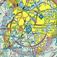
| Sectional chart |
|---|
|
 Download PDF
of official airport diagram from the FAA
| Airport distance calculator |
|---|
|
|
| Sunrise and sunset |
|---|
|
Times for 05-Mar-2026
| | Local
(UTC-5) | | Zulu
(UTC) |
|---|
| Morning civil twilight | | 06:44 | | 11:44 |
| Sunrise | | 07:10 | | 12:10 |
| Sunset | | 18:39 | | 23:39 |
| Evening civil twilight | | 19:05 | | 00:05 |
|
| Current date and time |
|---|
| Zulu (UTC) | 05-Mar-2026 19:38:43 |
|---|
| Local (UTC-5) | 05-Mar-2026 14:38:43 |
|---|
|
| METAR |
|---|
| KSDF | 051856Z 18006KT 10SM -RA SCT050 OVC095 16/14 A3006 RMK AO2 SLP176 P0014 T01560144
|
KLOU
4nm NE | 051853Z 18006KT 4SM RA BR OVC090 15/14 A3005 RMK AO2 SLP175 P0012 T01500144
|
KJVY
11nm N | 051915Z AUTO 19006KT 8SM -RA SCT007 SCT055 BKN085 16/16 A3003 RMK AO2
|
|
| TAF |
|---|
| KSDF | 051738Z 0518/0624 21009KT P6SM -RA BKN050 FM052100 22009KT P6SM VCSH BKN035 FM060000 19004KT P6SM -SHRA BKN050 FM060900 16004KT P6SM BKN100
|
|
| NOTAMs |
|---|
NOTAMs are issued by the DoD/FAA and will open in a separate window not controlled by AirNav.
|
|


