FAA INFORMATION EFFECTIVE 27 NOVEMBER 2025
Location
| FAA Identifier: | STP |
| Lat/Long: | 44-56-04.6410N 093-03-37.2328W
44-56.077350N 093-03.620547W
44.9346225,-93.0603424
(estimated) |
| Elevation: | 705.4 ft. / 215 m (estimated) |
| Variation: | 00E (2020) |
| From city: | 1 mile S of ST PAUL, MN |
| Time zone: | UTC -6 (UTC -5 during Daylight Saving Time) |
| Zip code: | 55107 |
Airport Operations
| Airport use: | Open to the public |
| Activation date: | 04/1940 |
| Control tower: | yes |
| ARTCC: | MINNEAPOLIS CENTER |
| FSS: | PRINCETON FLIGHT SERVICE STATION |
| NOTAMs facility: | STP (NOTAM-D service available) |
| Attendance: | CONTINUOUS |
| Pattern altitude: | 1905.4 ft. MSL |
| Wind indicator: | lighted |
| Segmented circle: | no |
| Lights: | WHEN ATCT CLSD, TO INCR INTST & ACTVT MALSR RWY 14; REIL RWY 31; PAPI RWY 13, 27, & 31; HIRL RWY 14/32 & 13/31; MIRL RWY 09/27; - CTAF. RWY 14 & 32 PAPI OPS CONSLY. |
| Beacon: | white-green (lighted land airport)
AIRPORT BEACON ON WEST EDGE OF ARPT. Operates sunset to sunrise. |
| Landing fee: | yes |
| International operations: | customs landing rights airport
CUSTOMS 0800-1630 DLY - OTR HRS, ONE HR PPR THRU FSS. |
Airport Communications
| CTAF: | 119.1 |
| UNICOM: | 122.95 |
| ATIS: | 118.35 |
| WX ASOS: | 118.35 (651-312-8888) |
| SAINT PAUL GROUND: | 121.675 [0600-2200 MON-FRI, 0700-2200 SAT-SUN] |
| SAINT PAUL TOWER: | 119.1 257.8 [0600-2200 MON-FRI, 0700-2200 SAT-SUN] |
| MINNEAPOLIS APPROACH: | 121.2 |
| MINNEAPOLIS DEPARTURE: | 121.2 |
| CLEARANCE DELIVERY: | 121.675 121.675 |
| ANG OPS: | 347.7 |
| NG OPS: | 49.65FM |
| OPS: | 126.2 139.2 299.1 41.5 |
| TWOLF STAR: | 126.95 |
| WX AWOS-3 at SGS (5 nm S): | 119.425 (651-457-8120) |
| WX ASOS at MSP (8 nm SW): | PHONE 218-203-0160 |
| WX AWOS-3 at 21D (10 nm NE): | 120.075 (651-779-5949) |
| WX AWOS-3 at ANE (14 nm NW): | PHONE 763-780-9025 |
| WX ASOS at MIC (15 nm NW): | PHONE 763-531-2343 |
| WX ASOS at FCM (18 nm W): | PHONE 952-941-4156 |
| WX AWOS-3 at LVN (20 nm S): | 118.0 (952-469-5850) |
- MINNEAPOLIS APCH CTL PROVIDES CLEARANCE DELIVERY ON 121.675 WHEN ATCT CLSD.
- EMERG FREQ NOT AVBL.
Nearby radio navigation aids
| VOR radial/distance | | VOR name | | Freq | | Var |
|---|
| MSPr071/7.8 | | MINNEAPOLIS VOR/DME | | 115.30 | | 02E |
| FCMr067/17.5 | | FLYING CLOUD VOR/DME | | 117.70 | | 01E |
| GEPr128/18.3 | | GOPHER VORTAC | | 117.30 | | 06E |
| FGTr010/18.9 | | FARMINGTON VORTAC | | 115.70 | | 06E |
Airport Services
| Fuel available: | 100LL JET-A
A:JET A LANDING FEE, CTC FBO. |
| Parking: | hangars and tiedowns |
| Airframe service: | MAJOR |
| Powerplant service: | MAJOR |
| Bottled oxygen: | NONE |
| Bulk oxygen: | HIGH/LOW |
Runway Information
Runway 14/32
| Dimensions: | 6491 x 150 ft. / 1978 x 46 m |
| Surface: | asphalt/grooved, in good condition |
| Weight bearing capacity: | | Single wheel: | 83.0 | | Double wheel: | 111.0 | | Double tandem: | 197.0 |
|
| Runway edge lights: | high intensity |
| RUNWAY 14 | | RUNWAY 32 |
| Latitude: | 44-56.468663N | | 44-55.582805N |
| Longitude: | 093-04.068377W | | 093-03.228347W |
| Elevation: | 704.5 ft. | | 704.6 ft. |
| Traffic pattern: | left | | left |
| Runway heading: | 146 | | 326 |
| Displaced threshold: | 343 ft. | | 382 ft. |
| Declared distances: | TORA:6491 TODA:6491 ASDA:6491 LDA:6148 | | TORA:6491 TODA:6491 ASDA:6491 LDA:6109 |
| Markings: | precision, in good condition | | precision, in good condition |
| Visual slope indicator: | 4-light PAPI on right (3.00 degrees glide path)
PAPI UNUSBL BYD 8 DEG LEFT OF CNTRLN. | | 4-light PAPI on left (3.00 degrees glide path) |
| RVR equipment: | touchdown, rollout | | touchdown, rollout |
| Approach lights: | MALSR: 1,400 foot medium intensity approach lighting system with runway alignment indicator lights | | |
| Runway end identifier lights: | no | | yes |
| Touchdown point: | yes, no lights | | yes, no lights |
| Instrument approach: | ILS/DME | | ILS/DME |
| Obstructions: | 12 ft. road, 586 ft. from runway, 32:1 slope to clear
RY 14: ROAD +13 179 FM END, 494R. | | 60 ft. trees, 1728 ft. from runway, 100 ft. right of centerline, 25:1 slope to clear
+8' TREE 95' FM RY END 380'R OF CNTRLN. |
Runway 13/31
| Dimensions: | 4004 x 150 ft. / 1220 x 46 m |
| Surface: | asphalt/grooved, in good condition |
| Weight bearing capacity: | | Single wheel: | 97.0 | | Double wheel: | 135.0 | | Double tandem: | 228.0 |
|
| Runway edge lights: | high intensity |
| RUNWAY 13 | | RUNWAY 31 |
| Latitude: | 44-56.351148N | | 44-55.947847N |
| Longitude: | 093-03.904043W | | 093-03.170418W |
| Elevation: | 704.7 ft. | | 701.2 ft. |
| Traffic pattern: | left | | left |
| Runway heading: | 128 | | 308 |
| Declared distances: | TORA:4004 TODA:4004 ASDA:4004 LDA:4004 | | TORA:4004 TODA:4004 ASDA:4004 LDA:4004 |
| Markings: | nonprecision, in good condition | | nonprecision, in good condition |
| Visual slope indicator: | 4-light PAPI on left (3.00 degrees glide path)
PAPI UNUSBL BYD 4 DEG RIGHT OF CNTRLN & UNUSBL INSIDE .5 NM. | | 4-light PAPI on left (3.00 degrees glide path) |
| Runway end identifier lights: | | | yes |
| Touchdown point: | yes, no lights | | yes, no lights |
| Obstructions: | none | | 9 ft. brush, 311 ft. from runway, 32 ft. left and right of centerline, 12:1 slope to clear |
Runway 9/27
| Dimensions: | 3642 x 100 ft. / 1110 x 30 m |
| Surface: | asphalt, in good condition |
| Weight bearing capacity: | |
| Runway edge lights: | medium intensity |
| RUNWAY 9 | | RUNWAY 27 |
| Latitude: | 44-56.091898N | | 44-56.084860N |
| Longitude: | 093-04.087320W | | 093-03.243615W |
| Elevation: | 700.7 ft. | | 701.0 ft. |
| Traffic pattern: | left | | right |
| Runway heading: | 091 | | 271 |
| Declared distances: | TORA:3642 TODA:3642 ASDA:3642 LDA:3642 | | TORA:3642 TODA:3642 ASDA:3642 LDA:3642 |
| Markings: | basic, in good condition | | basic, in good condition |
| Visual slope indicator: | | | 4-light PAPI on right (4.00 degrees glide path) |
| Touchdown point: | yes, no lights | | yes, no lights |
| Obstructions: | 33 ft. tree, 663 ft. from runway, 160 ft. right of centerline, 14:1 slope to clear | | 12 ft. tree, 284 ft. from runway, 118 ft. right of centerline, 7:1 slope to clear |
Airport Ownership and Management from official FAA records
| Ownership: | Publicly-owned |
| Owner: | METRO ARPT COMMSN
6040 28TH AVE, SO
MINNEAPOLIS, MN 55450
Phone 651-726-8100 |
| Manager: | BLAINE PETERSON
644 BAYFIELD
ST PAUL, MN 55107
Phone 651-224-4306
651-224-4306 |
Additional Remarks
| E60-32 | ENGINEERED MATERIALS ARRESTING SYSTEM (EMAS) 225 FT IN LENGTH BY 162 FT IN WIDTH LCTD AT THE DER 32. |
| E60-14 | ENGINEERED MATERIALS ARRESTING SYSTEM (EMAS) 280 FT IN LENGTH BY 162 FT IN WIDTH LCTD AT THE DER 14. |
| - | BIRD ROOSTING & FEEDING AREAS ALONG RIVER BANKS. |
| - | VOLUNTARY NOISE ABATEMENT PROCS IN EFCT. SEE ARPT WEBSITE FOR MORE INFO. |
| - | TWY A CLSD BTN A3 AND A4 EXC FOR WINGSPAN LESS THAN 101FT. |
| - | TWY B CLSD BTN MN JET RAMP AND TWY A (SOUTHERN CORNER) EXC FOR WINGSPAN LESS THAN 72FT DUE TO FLOOD WALL OBSTACLE. |
| - | RY 14 IS CALM WIND RY WHEN ATCT CLSD. |
| - | EXPECT HELICOPTER OPERATIONS ON TWY 'A' IN THE VICINITY OF THE CONTROL TWR, NORTH TO THE APPROACH END OF RY 14. |
| - | COLD TEMPERATURE AIRPORT. ALTITUDE CORRECTION REQUIRED AT OR BELOW -30C. |
| - | WHEN USING RYS 27 OR 31 HAZARDOUS RIVER TFC MAY EXIST. |
| - | DEER, BIRDS & WILDLIFE ON & INVOF ARPT. |
| - | SE ARR & DEP AVOID TFC PATTERN OPERATIONS AT SOUTH ST. PAUL ARPT 164 DEG 5 NM AT & BLO 1720 MSL. |
| - | PPR ACFT OVER 100,000 LBS, CTC AMGR. |
| - | COMPLEX AIRPORT GEOMETRY. VERIFY CORRECT COMPASS HEADING PRIOR TO DEPARTURE. |
Instrument Procedures
NOTE: All procedures below are presented as PDF files. If you need a reader for these files, you should download the free Adobe Reader.NOT FOR NAVIGATION. Please procure official charts for flight.
FAA instrument procedures published for use from 27 November 2025 at 0901Z to 25 December 2025 at 0900Z.
STARs - Standard Terminal Arrivals |
|---|
| AGUDE SIX **NEW** | |
download (217KB) |
| ENCEE THREE (RNAV) | |
download (159KB) |
| GOPHER ONE | |
download (247KB) |
| TWOLF FOUR | |
download (168KB) |
IAPs - Instrument Approach Procedures |
|---|
| ILS OR LOC RWY 14 **CHANGED** | |
download (272KB) |
| ILS OR LOC RWY 32 **CHANGED** | |
download (289KB) |
| RNAV (GPS) RWY 14 **CHANGED** | |
download (235KB) |
| RNAV (GPS) RWY 32 **CHANGED** | |
download (236KB) |
| NOTE: Special Alternate Minimums apply **CHANGED** | |
download (176KB) |
Departure Procedures |
|---|
| COULT SEVEN | |
2 pages:
[1] [2] (323KB) |
| KBREW TWO | |
download (266KB) |
| ORSKY THREE | |
2 pages:
[1] [2] (348KB) |
| ROCHESTER ONE | |
2 pages:
[1] [2] (366KB) |
| SCHEP ONE | |
2 pages:
[1] [2] (332KB) |
| WLSTN SEVEN | |
2 pages:
[1] [2] (301KB) |
| ZMBRO SEVEN | |
2 pages:
[1] [2] (369KB) |
| NOTE: Special Take-Off Minimums/Departure Procedures apply | |
download (406KB) |
Other nearby airports with instrument procedures:
KSGS - South St Paul Municipal Airport/Richard E Fleming Field (5 nm S)
KMSP - Minneapolis-St Paul International/Wold-Chamberlain Airport (8 nm SW)
21D - Lake Elmo Airport (10 nm NE)
KANE - Anoka County/Blaine Airport (Janes Field) (14 nm NW)
KMIC - Crystal Airport (15 nm NW)
KFCM - Flying Cloud Airport (18 nm W)
KLVN - Airlake Airport (20 nm S)
|
|

Road maps at:
MapQuest
Bing
Google
| Aerial photo |
|---|
WARNING: Photo may not be current or correct
 Photo by Alan Matson
Photo taken 06-Sep-2014
looking south.
Photo by Alan Matson
Photo taken 06-Sep-2014
looking south.
Do you have a better or more recent aerial photo of St Paul Downtown Airport Holman Field that you would like to share? If so, please send us your photo.
|
| Sectional chart |
|---|
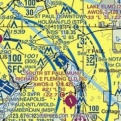
|
 Download PDF
of official airport diagram from the FAA
| Airport distance calculator |
|---|
|
|
| Sunrise and sunset |
|---|
|
Times for 01-Dec-2025
| | Local
(UTC-6) | | Zulu
(UTC) |
|---|
| Morning civil twilight | | 06:58 | | 12:58 |
| Sunrise | | 07:31 | | 13:31 |
| Sunset | | 16:32 | | 22:32 |
| Evening civil twilight | | 17:05 | | 23:05 |
|
| Current date and time |
|---|
| Zulu (UTC) | 01-Dec-2025 10:41:21 |
|---|
| Local (UTC-6) | 01-Dec-2025 04:41:21 |
|---|
|
| METAR |
|---|
| KSTP | 010953Z AUTO 26003KT 10SM CLR M13/M15 A3042 RMK AO2 SLP313 I1000 T11331150 $
|
KSGS
6nm SW | 011015Z AUTO 00000KT 10SM CLR M14/M15 A3039 RMK AO2 T11371152
|
KMSP
8nm SW | 010953Z 22003KT 10SM BKN170 M14/M17 A3040 RMK AO2 SLP312 T11391167 $
|
K21D
9nm NE | 011015Z AUTO 00000KT 10SM CLR M17/M19 A3039 RMK AO2
|
KANE
14nm NW | 011015Z AUTO 00000KT 10SM CLR M14/M16 A3036 RMK AO2
|
KMIC
15nm NW | 010953Z AUTO 16003KT 10SM CLR M14/M16 A3038 RMK AO2 SLP305 I1000 T11441161
|
KFCM
18nm W | 010953Z AUTO 20003KT 10SM CLR M16/M18 A3038 RMK AO2 SLP306 T11611178
|
|
| TAF |
|---|
KMSP
8nm SW | 010848Z 0109/0212 22004KT P6SM FEW025 BKN100 FM011500 20008KT P6SM OVC015 PROB30 0116/0121 5SM -SHSN FM020100 21006KT P6SM OVC012
|
|
| NOTAMs |
|---|
NOTAMs are issued by the DoD/FAA and will open in a separate window not controlled by AirNav.
|
|


