FAA INFORMATION EFFECTIVE 14 MAY 2026
Location
| FAA Identifier: | EZM |
| Lat/Long: | 32-12-59.0000N 083-07-43.2000W
32-12.983333N 083-07.720000W
32.2163889,-83.1286667
(estimated) |
| Elevation: | 303.4 ft. / 92.5 m (surveyed) |
| Variation: | 04W (2000) |
| From city: | 3 miles E of EASTMAN, GA |
| Time zone: | UTC -4 (UTC -5 during Standard Time) |
| Zip code: | 31023 |
Airport Operations
| Airport use: | Open to the public |
| Control tower: | yes |
| ARTCC: | JACKSONVILLE CENTER |
| FSS: | MACON FLIGHT SERVICE STATION |
| NOTAMs facility: | MCN (NOTAM-D service available) |
| Attendance: | MON-SAT 0800-1800, ALL SUN 1300-1700 |
| Wind indicator: | lighted |
| Segmented circle: | yes |
| Lights: | ACTVT MALSR RWY 02; REIL RWY 20; PAPI RWY 02 & 20; HIRL RWY 02/20 - CTAF. |
| Beacon: | white-green (lighted land airport)
DUSK-2400. |
Airport Communications
| CTAF: | 124.55 |
| UNICOM: | 122.95 |
| ATIS: | 119.425 |
| WX AWOS-3: | 119.425 (478-374-9979) |
| HEART OF GEORGIA GROUND: | 121.175 [MON-THU 0700-1800, FRI 0800-1200.] |
| HEART OF GEORGIA TOWER: | 124.55 [MON-THU 0700-1800, FRI 0800-1200.] |
| WX AWOS-3PT at 48A (13 nm NW): | 120.975 (478-271-5897) |
| WX AWOS-3PT at MQW (15 nm SE): | 120.000 (229-868-7472) |
- APCH/DEP SVC PRVDD BY JACKSONVILLE ARTCC ON FREQS 127.575/269.025 (ALMA RCAG).
Nearby radio navigation aids
| VOR radial/distance | | VOR name | | Freq | | Var |
|---|
| VNAr088/18.7 | | VIENNA VORTAC | | 116.50 | | 01E |
| DBNr221/25.7 | | DUBLIN VORTAC | | 113.10 | | 05W |
| NDB name | | Hdg/Dist | | Freq | | Var | | ID |
|---|
| EASTMAN | | 018/5.2 | | 366 | | 04W | | EZM | . --.. -- |
| FITZGERALD | | 018/37.1 | | 362 | | 05W | | SUR | ... ..- .-. |
| CONEY | | 077/39.5 | | 400 | | 06W | | OHY | --- .... -.-- |
Airport Services
| Fuel available: | 100LL JET-A+
100LL:24 HR SELF-FUELING WITH CREDIT CARD. |
| Parking: | tiedowns |
| Airframe service: | MAJOR |
| Powerplant service: | MAJOR |
| Bottled oxygen: | NONE |
| Bulk oxygen: | NONE |
Runway Information
Runway 2/20
| Dimensions: | 6506 x 100 ft. / 1983 x 30 m |
| Surface: | asphalt/grooved, in excellent condition |
| Weight bearing capacity: | | Single wheel: | 75.0 | | Double wheel: | 120.0 |
|
| Runway edge lights: | high intensity |
| RUNWAY 2 | | RUNWAY 20 |
| Latitude: | 32-12.466500N | | 32-13.500900N |
| Longitude: | 083-07.887483W | | 083-07.552443W |
| Elevation: | 295.1 ft. | | 298.0 ft. |
| Traffic pattern: | left | | left |
| Runway heading: | 019 magnetic, 015 true | | 199 magnetic, 195 true |
| Markings: | precision, in good condition | | precision, in good condition |
| Visual slope indicator: | 4-light PAPI on left (3.00 degrees glide path) | | 4-light PAPI on left (3.00 degrees glide path) |
| Approach lights: | MALSR: 1,400 foot medium intensity approach lighting system with runway alignment indicator lights | | |
| Runway end identifier lights: | | | yes |
| Touchdown point: | yes, no lights | | yes, no lights |
| Instrument approach: | LOC/GS | | |
| Obstructions: | none | | 81 ft. trees, 2277 ft. from runway, 520 ft. right of centerline, 25:1 slope to clear
10 FT TREES, 363 FT RIGHT OF CNTRLN AT THLD. |
Airport Ownership and Management from official FAA records
| Ownership: | Publicly-owned |
| Owner: | HEART OF GA REG APT AUTH
317 AIRPORT RD.
EASTMAN, GA 31023
Phone 478-220-5091
TWR PHONE 478-448-4713. MGR CELL PHONE 478-231-8305. |
| Manager: | JEFF FORDHAM
317 AIRPORT RD.
EASTMAN, GA 31023
Phone 478-220-5091
TWR PHONE: 478-448-4713. MGR CELL PHONE 478-231-8305 |
Additional Remarks
| - | FLT TRNG IN AREA. |
| - | DEER AND OTR WILDLIFE INVOF ARPT. |
| - | CTAF & TWR FREQ - 124.55. |
| - | FOR CD WHEN ATCT IS CLSD CTC JACKSONVILLE ARTCC AT 904-845-1592. |
Instrument Procedures
NOTE: All procedures below are presented as PDF files. If you need a reader for these files, you should download the free Adobe Reader.NOT FOR NAVIGATION. Please procure official charts for flight.
FAA instrument procedures published for use from 14 May 2026 at 0901Z to 11 June 2026 at 0900Z.
IAPs - Instrument Approach Procedures |
|---|
| ILS OR LOC RWY 02 | |
download (249KB) |
| RNAV (GPS) RWY 02 | |
download (228KB) |
| RNAV (GPS) RWY 20 | |
download (226KB) |
| NOTE: Special Alternate Minimums apply | |
download (48KB) |
| NOTE: Special Take-Off Minimums/Departure Procedures apply | |
download (189KB) |
Other nearby airports with instrument procedures:
48A - Cochran Airport (13 nm NW)
KMQW - Telfair-Wheeler Airport (15 nm SE)
KDBN - W H 'Bud' Barron Airport (22 nm N)
KAZE - Hazlehurst Airport (32 nm SE)
KFZG - Fitzgerald Municipal Airport (33 nm S)
|
|

Road maps at:
MapQuest
Bing
Google
| Aerial photo |
|---|
WARNING: Photo may not be current or correct
 Photo by Dylan Roland
Taken in the Summer of 2014
looking north at 3500ft.
Photo by Dylan Roland
Taken in the Summer of 2014
looking north at 3500ft.
Do you have a better or more recent aerial photo of Heart of Georgia Regional Airport that you would like to share? If so, please send us your photo.
|
| Sectional chart |
|---|
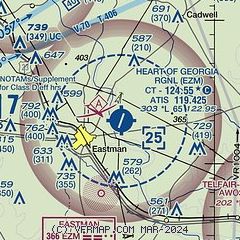
|
| Airport distance calculator |
|---|
|
|
| Sunrise and sunset |
|---|
|
Times for 06-Jun-2026
| | Local
(UTC-4) | | Zulu
(UTC) |
|---|
| Morning civil twilight | | 05:59 | | 09:59 |
| Sunrise | | 06:27 | | 10:27 |
| Sunset | | 20:36 | | 00:36 |
| Evening civil twilight | | 21:04 | | 01:04 |
|
| Current date and time |
|---|
| Zulu (UTC) | 06-Jun-2026 21:48:03 |
|---|
| Local (UTC-4) | 06-Jun-2026 17:48:03 |
|---|
|
| METAR |
|---|
| KEZM | 062135Z AUTO 21004KT 10SM SCT065 30/15 A3007 RMK AO2
|
K48A
13nm NW | 062135Z AUTO 23006KT 10SM CLR A3004 RMK AO2
|
KMQW
15nm SE | 062135Z AUTO 14006KT 10SM CLR 30/15 A3004 RMK AO2
|
|
| TAF |
|---|
KWRB
33nm NW | 061900Z 0619/0801 18009KT 9999 FEW070 FEW180 QNH2999INS BECMG 0708/0709 VRB06KT 9999 SCT180 QNH3001INS BECMG 0718/0719 28009KT 9999 SCT070 BKN120 QNH2998INS TX31/0619Z TN20/0709Z
|
KMCN
38nm NW | 061723Z 0618/0718 13006KT P6SM SCT050 FM070000 VRB03KT P6SM FEW250 FM071700 VRB03KT P6SM BKN040
|
|
| NOTAMs |
|---|
NOTAMs are issued by the DoD/FAA and will open in a separate window not controlled by AirNav.
|
|


