FAA INFORMATION EFFECTIVE 27 NOVEMBER 2025
Location
| FAA Identifier: | GLE |
| Lat/Long: | 33-39-07.9000N 097-11-50.2000W
33-39.131667N 097-11.836667W
33.6521944,-97.1972778
(estimated) |
| Elevation: | 845.5 ft. / 257.7 m (surveyed) |
| Variation: | 03E (2020) |
| From city: | 3 miles W of GAINESVILLE, TX |
| Time zone: | UTC -6 (UTC -5 during Daylight Saving Time) |
| Zip code: | 76240 |
Airport Operations
| Airport use: | Open to the public |
| Activation date: | 07/1943 |
| Control tower: | no |
| ARTCC: | FORT WORTH CENTER |
| FSS: | FORT WORTH FLIGHT SERVICE STATION |
| NOTAMs facility: | GLE (NOTAM-D service available) |
| Attendance: | 0800-1700 |
| Wind indicator: | lighted |
| Segmented circle: | yes |
| Lights: | DUSK-DAWN. MIRL RWY 18/36 PRESET LOW INTST; TO INCR INTST ACTVT - CTAF. PAPI RWYS 18 & 36 OPR CONSLY. |
| Beacon: | white-green (lighted land airport)
Operates sunset to sunrise. |
Airport Communications
| CTAF/UNICOM: | 123.0 |
| WX AWOS-3: | 118.375 (940-612-3549) |
- APCH/DEP CTL SVC PRVDD BY FORT WORTH ARTCC (ZFW) ON FREQS 124.75/323.0 (GAINESVILLE RCAG).
Nearby radio navigation aids
| VOR radial/distance | | VOR name | | Freq | | Var |
|---|
| UKWr071/32.0 | | BOWIE VORTAC | | 117.15 | | 06E |
| ADMr176/33.6 | | ARDMORE VORTAC | | 116.70 | | 06E |
| NDB name | | Hdg/Dist | | Freq | | Var | | ID |
|---|
| DENISON | | 245/28.4 | | 341 | | 03E | | DNI | -.. -. .. |
Airport Services
| Fuel available: | 100LL JET-A+
100LL:100LL SELF-SERVE & FULL SERVE. |
| Parking: | hangars and tiedowns |
| Airframe service: | MAJOR |
| Powerplant service: | MAJOR |
| Bulk oxygen: | NONE |
Runway Information
Runway 18/36
| Dimensions: | 6000 x 100 ft. / 1829 x 30 m |
| Surface: | asphalt, in excellent condition |
| Weight bearing capacity: | | Single wheel: | 30.0 | | Double wheel: | 50.0 |
|
| Runway edge lights: | medium intensity |
| RUNWAY 18 | | RUNWAY 36 |
| Latitude: | 33-39.674653N | | 33-38.685618N |
| Longitude: | 097-11.968593W | | 097-11.991825W |
| Elevation: | 845.4 ft. | | 792.4 ft. |
| Traffic pattern: | left | | left |
| Runway heading: | 178 magnetic, 181 true | | 358 magnetic, 001 true |
| Markings: | nonprecision, in good condition | | nonprecision, in good condition |
| Visual slope indicator: | 2-light PAPI on right (3.00 degrees glide path) | | 2-light PAPI on left (3.00 degrees glide path) |
| Runway end identifier lights: | yes | | yes |
| Touchdown point: | yes, no lights | | yes, no lights |
| Obstructions: | 45 ft. trees, 1325 ft. from runway, 285 ft. right of centerline, 25:1 slope to clear
ALSO 32 FT PLINE, 1290 FT DSTC, 445 L/R. APCH SLOPE 34:1. | | 35 ft. trees, 1555 ft. from runway, 38:1 slope to clear |
Runway 13/31
| Dimensions: | 4307 x 75 ft. / 1313 x 23 m |
| Surface: | asphalt, in poor condition
EXTSV CRACKING. |
| Weight bearing capacity: | |
| Runway edge markings: | MRKGS FADED.
RWY HAS AIM POINTS. |
| RUNWAY 13 | | RUNWAY 31 |
| Latitude: | 33-39.305875N | | 33-38.824185N |
| Longitude: | 097-11.948148W | | 097-11.324257W |
| Elevation: | 826.3 ft. | | 792.2 ft. |
| Traffic pattern: | left | | left |
| Runway heading: | 130 magnetic, 133 true | | 310 magnetic, 313 true |
| Markings: | basic, in poor condition | | basic, in poor condition |
| Runway end identifier lights: | no | | no |
| Touchdown point: | yes, no lights | | yes, no lights |
| Obstructions: | 70 ft. trees, 1900 ft. from runway, 275 ft. right of centerline, 24:1 slope to clear | | 22 ft. trees, 650 ft. from runway, 135 ft. right of centerline, 20:1 slope to clear |
Airport Ownership and Management from official FAA records
| Ownership: | Publicly-owned |
| Owner: | CITY OF GAINESVILLE
200 S. RUSK
GAINESVILLE, TX 76240
Phone 940-668-4500 |
| Manager: | BRENTON PORTER
2300 AIRPORT DR
GAINESVILLE, TX 76240
Phone 940-668-4565 |
Additional Remarks
| - | FOR CD CTC FORT WORTH ARTCC AT 817-858-7584. |
| - | HEL SKID LDG PROHIBITED ON ALL PAVED SFCS. |
Instrument Procedures
NOTE: All procedures below are presented as PDF files. If you need a reader for these files, you should download the free Adobe Reader.NOT FOR NAVIGATION. Please procure official charts for flight.
FAA instrument procedures published for use from 27 November 2025 at 0901Z to 25 December 2025 at 0900Z.
IAPs - Instrument Approach Procedures |
|---|
| RNAV (GPS) RWY 18 | |
download (249KB) |
| RNAV (GPS) RWY 36 | |
download (210KB) |
| NOTE: Special Alternate Minimums apply | |
download (38KB) |
| NOTE: Special Take-Off Minimums/Departure Procedures apply | |
download (167KB) |
Other nearby airports with instrument procedures:
KGYI - North Texas Regional Airport/Perrin Field (26 nm E)
KDTO - Denton Enterprise Airport (27 nm S)
0F2 - Bowie Municipal Airport (29 nm W)
1F0 - Ardmore Downtown Executive Airport (30 nm N)
KSWI - Sherman Municipal Airport (31 nm E)
|
|

Road maps at:
MapQuest
Bing
Google
| Aerial photo |
|---|
WARNING: Photo may not be current or correct

Do you have a better or more recent aerial photo of Gainesville Municipal Airport that you would like to share? If so, please send us your photo.
|
| Sectional chart |
|---|
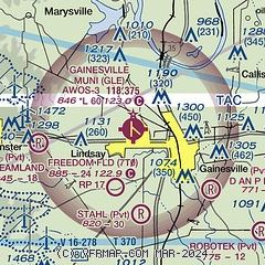
|
 Download PDF
of official airport diagram from the FAA
| Airport distance calculator |
|---|
|
|
| Sunrise and sunset |
|---|
|
Times for 27-Nov-2025
| | Local
(UTC-6) | | Zulu
(UTC) |
|---|
| Morning civil twilight | | 06:46 | | 12:46 |
| Sunrise | | 07:13 | | 13:13 |
| Sunset | | 17:20 | | 23:20 |
| Evening civil twilight | | 17:47 | | 23:47 |
|
| Current date and time |
|---|
| Zulu (UTC) | 28-Nov-2025 05:07:19 |
|---|
| Local (UTC-6) | 27-Nov-2025 23:07:19 |
|---|
|
| TAF |
|---|
KAFW
42nm S | 280250Z 2803/2824 10004KT P6SM SCT250 FM281200 15011KT P6SM OVC050
|
KDUA
44nm NE | 271720Z 2718/2818 VRB03KT P6SM FEW250 FM280700 13005KT P6SM BKN250 FM281700 16009G14KT P6SM SCT130
|
KDFW
46nm S | 280250Z 2803/2906 10004KT P6SM SCT250 FM281200 15011KT P6SM OVC050 FM290500 16014G24KT P6SM -SHRA VCTS BKN025 OVC035CB
|
KFTW
50nm S | 280250Z 2803/2824 10004KT P6SM SCT250 FM281200 14012KT P6SM OVC050
|
|
| NOTAMs |
|---|
NOTAMs are issued by the DoD/FAA and will open in a separate window not controlled by AirNav.
|
|


