FAA INFORMATION EFFECTIVE 14 MAY 2026
Location
| FAA Identifier: | TNT |
| Lat/Long: | 25-51-42.5000N 080-53-49.2000W
25-51.708333N 080-53.820000W
25.8618056,-80.8970000
(estimated) |
| Elevation: | 12.7 ft. / 3.9 m (surveyed) |
| Variation: | 05W (2005) |
| From city: | 36 miles W of MIAMI, FL |
| Time zone: | UTC -4 (UTC -5 during Standard Time) |
| Zip code: | 34141 |
Airport Operations
| Airport use: | Open to the public, ARPT CLSD TO PUBLIC EXCP BY ARRANGEMENT WITH MIAMI-DADE AVIATION DEPT MIAMI 305-869-1660. |
| Control tower: | no |
| ARTCC: | MIAMI CENTER |
| FSS: | MIAMI FLIGHT SERVICE STATION |
| NOTAMs facility: | MIA (NOTAM-D service available) |
| Attendance: | WED SAT 0800-1800 |
| Wind indicator: | lighted |
| Segmented circle: | yes |
| Beacon: | white-green (lighted land airport)
Operates sunset to sunrise. |
| Landing fee: | yes |
Airport Communications
| CTAF/UNICOM: | 123.0 |
| WX AWOS-3: | 119.075 (239-695-9198) |
| MIAMI APPROACH: | 128.6 |
| MIAMI DEPARTURE: | 128.6 |
Nearby radio navigation aids
| VOR radial/distance | | VOR name | | Freq | | Var |
|---|
| DHPr281/29.8 | | DOLPHIN VORTAC | | 113.90 | | 04W |
Airport Services
| Airframe service: | NONE |
| Powerplant service: | NONE |
| Bottled oxygen: | NONE |
| Bulk oxygen: | NONE |
Runway Information
Runway 9/27
| Dimensions: | 10499 x 150 ft. / 3200 x 46 m |
| Surface: | asphalt/porous friction courses, in fair condition |
| Weight bearing capacity: | | PCN 65 /F/A/X/T | | Single wheel: | 130.0 | | Double wheel: | 200.0 | | Double tandem: | 400.0 | | Dual double tandem: | 800.0 |
|
| Runway edge lights: | high intensity |
| RUNWAY 9 | | RUNWAY 27 |
| Latitude: | 25-51.708232N | | 25-51.707022N |
| Longitude: | 080-54.777252W | | 080-52.861753W |
| Elevation: | 12.6 ft. | | 12.4 ft. |
| Traffic pattern: | left | | right |
| Runway heading: | 095 magnetic, 090 true | | 275 magnetic, 270 true |
| Markings: | precision, in fair condition | | precision, in fair condition |
| Touchdown point: | yes, no lights | | yes, no lights |
| Instrument approach: | ILS | | |
| Obstructions: | 10 ft. road, 400 ft. from runway, 193 ft. right of centerline, 20:1 slope to clear | | 26 ft. trees, 1075 ft. from runway, 290 ft. right of centerline, 34:1 slope to clear |
Airport Ownership and Management from official FAA records
| Ownership: | Publicly-owned |
| Owner: | MIAMI-DADE COUNTY
MIAMI-DADE AVIATION DEPARTMENT, PO BOX 025504
MIAMI, FL 33102-5504
Phone 305-876-7038 |
| Manager: | JOSEPH KINNEBREW
PO BOX 025504
MIAMI, FL 33102-5504
Phone 305-876-7484
AIRPORT PHYSICAL ADDRESS: 54757 EAST TAMIAMI TRAIL, OCHOPPI, FL 34141 239-695-3300, FAX: 305-876-0565 |
Additional Remarks
| A100 | ACR TRNG OPNS ONLY. |
| - | THREE 8IN WELLS FLUSH MTD BTN RWY AND TWY. |
| - | FEE FOR USE FOR ACFT OVER 12500 LBS. |
| - | BE ALERT TO LOW FLYING NATIONAL PARK SVC ACFT ALL QUADRANTS. |
| - | NO NGT TIME OPNS EXC WITH PRIOR PMSN FM MIAMI-DADE AVN DEPT 305-869-1660. |
| - | FOR CD IF UNA TO CTC ON FSS FREQ, CTC MIAMI APCH AT 305-869-5432. |
| - | WILDLIFE ON AND INVOF ARPT. |
| - | 24 HR PPR FOR ACFT EQUIPPED WITH WEATHER MODIFICATION OR GEOENGINEERING EQPT 305-793-3158. |
Instrument Procedures
NOTE: All procedures below are presented as PDF files. If you need a reader for these files, you should download the free Adobe Reader.NOT FOR NAVIGATION. Please procure official charts for flight.
FAA instrument procedures published for use from 14 May 2026 at 0901Z to 11 June 2026 at 0900Z.
IAPs - Instrument Approach Procedures |
|---|
| RNAV (GPS) RWY 09 | |
download (245KB) |
Other nearby airports with instrument procedures:
KTMB - Miami Executive Airport (28 nm SE)
X51 - Miami Homestead General Aviation Airport (29 nm SE)
KMIA - Miami International Airport (33 nm E)
KOPF - Miami-Opa Locka Executive Airport (34 nm E)
KHST - Homestead Air Reserve Base (36 nm SE)
|
|

Road maps at:
MapQuest
Bing
Google
| Aerial photo |
|---|
WARNING: Photo may not be current or correct

Do you have a better or more recent aerial photo of Dade-Collier Training and Transition Airport that you would like to share? If so, please send us your photo.
|
| Sectional chart |
|---|
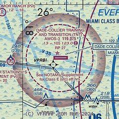
|
| Airport distance calculator |
|---|
|
|
| Sunrise and sunset |
|---|
|
Times for 28-May-2026
| | Local
(UTC-4) | | Zulu
(UTC) |
|---|
| Morning civil twilight | | 06:08 | | 10:08 |
| Sunrise | | 06:34 | | 10:34 |
| Sunset | | 20:08 | | 00:08 |
| Evening civil twilight | | 20:33 | | 00:33 |
|
| Current date and time |
|---|
| Zulu (UTC) | 28-May-2026 15:16:39 |
|---|
| Local (UTC-4) | 28-May-2026 11:16:39 |
|---|
|
| METAR |
|---|
KTMB
28nm SE | 281453Z 13005KT 10SM FEW030 25/24 A3004 RMK AO2 SLP173 T02500244 50005
|
KMIA
32nm E | 281453Z 18005KT 10SM -RA FEW030 BKN150 BKN250 26/23 A3004 RMK AO2 RAB47 SLP172 CB DSNT ALQDS MOV N P0000 60002 T02560233 51004 $
|
KOPF
33nm E | 281453Z 14006KT 10SM CLR 27/24 A3004 RMK AO2 SLP174 60001 T02720244 50003
|
KHWO
37nm E | 281453Z 15008KT 10SM SCT030 28/24 A3004 RMK AO2 RAE02 SLP172 6//// T02830244 50000 PNO $
|
KHST
37nm SE | 281455Z 12004KT 10SM VCTS BKN020 BKN050 25/24 A3004 RMK AO2A RAB1355E01DZB01E05 TSB1355E38 SLP176 P0000 60080 T02490235 51008
|
KFLL
42nm E | 281453Z VRB03KT 10SM FEW030 SCT060 BKN110 27/24 A3003 RMK AO2 RAE47 SLP169 P0000 60007 T02720239 50007 $
|
KMKY
43nm W | 281456Z AUTO 14004KT 10SM CLR 28/25 A3003 RMK AO2 LTG DSNT E RAB1359E18 SLP170 6//// T02780250 50006 PNO $
|
KFXE
43nm NE | 281453Z VRB03KT 10SM FEW120 26/26 A3004 RMK AO2 RAB09E38 SLP174 P0000 60035 T02610261 53001 $
|
KPMP
48nm NE | 281453Z 16010KT 10SM SCT090 BKN110 28/23 A3004 RMK AO2 SLP174 60002 T02780233 52004
|
KAPF
50nm W | 281453Z 16006KT 10SM SCT021 SCT028 29/25 A3002 RMK AO2 LTG DSNT SE SLP165 T02890250 51006
|
|
| TAF |
|---|
KTMB
28nm SE | 281352Z 2814/2912 15008KT P6SM VCTS FEW025 SCT035CB BKN060 TEMPO 2821/2824 VRB15G25KT 2SM TSRA BKN012CB FM290400 VRB04KT P6SM SCT020 BKN060 OVC100
|
KMIA
32nm E | 281358Z 2814/2918 14008KT P6SM VCTS SCT035CB SCT050 BKN250 TEMPO 2821/2824 VRB15G25KT 2SM TSRA BKN012CB FM290400 VRB04KT P6SM SCT020 BKN060 OVC100
|
KOPF
33nm E | 281357Z 2814/2912 15008KT P6SM VCTS FEW025 SCT035CB BKN120 TEMPO 2821/2824 VRB15G25KT 2SM TSRA BKN012CB FM290400 VRB04KT P6SM SCT020 BKN060 OVC100
|
|
| NOTAMs |
|---|
NOTAMs are issued by the DoD/FAA and will open in a separate window not controlled by AirNav.
|
|


