FAA INFORMATION EFFECTIVE 02 OCTOBER 2025
Location
| FAA Identifier: | VAY |
| Lat/Long: | 39-56-34.4000N 074-50-44.7000W
39-56.573333N 074-50.745000W
39.9428889,-74.8457500
(estimated) |
| Elevation: | 52.8 ft. / 16.1 m (surveyed) |
| Variation: | 12W (2005) |
| From city: | 4 miles SW of MOUNT HOLLY, NJ |
| Time zone: | UTC -4 (UTC -5 during Standard Time) |
| Zip code: | 08055 |
Airport Operations
| Airport use: | Open to the public |
| Activation date: | 01/1956 |
| Control tower: | no |
| ARTCC: | NEW YORK CENTER |
| FSS: | MILLVILLE FLIGHT SERVICE STATION |
| NOTAMs facility: | VAY (NOTAM-D service available) |
| Attendance: | APR-OCT 0800-2000, NOV-MAR 0800-1800
ARPT UNATNDD THANKSGIVING & CHRISTMAS DAY. CHRISTMAS & THANKSGIVING EVE HRS 0800-1200. NEW YEARS DAY HRS 1100-1800. |
| Pattern altitude: | 852.8 ft. MSL |
| Wind indicator: | lighted |
| Segmented circle: | yes |
| Lights: | ACTVT MIRL RY 08/26 AND REIL RY 08 & 26 -123.3. |
| Beacon: | white-green (lighted land airport)
Operates sunset to sunrise. |
Airport Communications
| CTAF/UNICOM: | 122.8 |
| WX ASOS: | 119.325 (609-267-1176) |
| MC GUIRE APPROACH: | 126.475 |
| MC GUIRE DEPARTURE: | 126.475 |
| WX ASOS at PNE (11 nm NW): | PHONE 215-897-9068 |
| WX AWOS-AV at N81 (17 nm S): | 122.7 |
| WX ASOS at PHL (19 nm W): | 133.4 (215-492-9617) |
Nearby radio navigation aids
| VOR radial/distance | | VOR name | | Freq | | Var |
|---|
| GXUr263/12.1 | | MC GUIRE VORTAC | | 110.60 | | 12W |
| ARDr181/18.8 | | YARDLEY VOR/DME | | 108.20 | | 10W |
| CYNr302/20.5 | | COYLE VORTAC | | 113.40 | | 10W |
| RBVr236/22.4 | | ROBBINSVILLE VORTAC | | 113.80 | | 10W |
| VCNr023/24.9 | | CEDAR LAKE VOR/DME | | 115.20 | | 10W |
| OODr059/28.0 | | WOODSTOWN VORTAC | | 112.80 | | 10W |
| ACYr347/31.8 | | ATLANTIC CITY VORTAC | | 117.15 | | 10W |
| PTWr126/36.8 | | POTTSTOWN VORTAC | | 116.50 | | 09W |
| MXEr097/38.0 | | MODENA VORTAC | | 113.20 | | 09W |
| COLr246/38.5 | | COLTS NECK VOR/DME | | 115.40 | | 11W |
| DQOr076/38.5 | | DUPONT VORTAC | | 114.00 | | 10W |
| SBJr197/38.7 | | SOLBERG VOR/DME | | 112.90 | | 10W |
| NDB name | | Hdg/Dist | | Freq | | Var | | ID |
|---|
| LAKEHURST | | 266/24.2 | | 396 | | 11W | | NEL | -. . .-.. |
| RAINBOW | | 034/34.2 | | 363 | | 11W | | RNB | .-. -. -... |
Airport Services
| Fuel available: | 100LL JET-A
A:JET A AVAILABLE 24-HOUR SELF SERVICE WITH CREDIT CARD OR TRUCK DURING ATTENDED HOURS. |
| Parking: | hangars and tiedowns |
| Airframe service: | MAJOR |
| Powerplant service: | MAJOR |
| Bottled oxygen: | NONE |
| Bulk oxygen: | NONE |
Runway Information
Runway 8/26
| Dimensions: | 3881 x 50 ft. / 1183 x 15 m |
| Surface: | asphalt, in good condition |
| Weight bearing capacity: | |
| Runway edge lights: | medium intensity |
| RUNWAY 8 | | RUNWAY 26 |
| Latitude: | 39-56.462425N | | 39-56.683053N |
| Longitude: | 074-51.134992W | | 074-50.355553W |
| Elevation: | 43.8 ft. | | 51.8 ft. |
| Traffic pattern: | left | | right |
| Runway heading: | 082 magnetic, 070 true | | 262 magnetic, 250 true |
| Markings: | nonprecision, in fair condition | | nonprecision, in fair condition |
| Visual slope indicator: | 2-light PAPI on right (3.25 degrees glide path) | | 2-light PAPI on right (3.00 degrees glide path) |
| Runway end identifier lights: | yes | | yes |
| Touchdown point: | yes, no lights | | yes, no lights |
| Obstructions: | 54 ft. tree, 550 ft. from runway, 170 ft. right of centerline, 6:1 slope to clear | | 45 ft. tree, 909 ft. from runway, 99 ft. left of centerline, 15:1 slope to clear |
Airport Ownership and Management from official FAA records
| Ownership: | Publicly-owned |
| Owner: | N.J. DEPT. OF TRANSPORTATION
1035 PARKWAY AVE., P.O. BOX 600
TRENTON, NJ 08625-0600
Phone 609-530-2900 |
| Manager: | MINDY KIMBALL
68 STACY HAINES RD.
LUMBERTON, NJ 08048
Phone 609-267-3131 |
Additional Remarks
| - | TREES ALONG SIDES OF RY PRIMARILY NW. |
| - | BALLS MKG PLINES ON APH TO RY 08 FADED. |
| - | DEER ON & INVOF ARPT. |
| - | HELICOPTER TAKEOFFS AND LANDINGS RESTRICTED TO RY 08/26 ONLY. |
| - | PARALLEL TAXIWAY NON-STANDARD WIDTH, 18 FT ASP. |
| - | AVOID OVERFLYING HOUSING AREA WNW OF ARPT BELOW 300 FT WHEN IN THE TRAFFIC PATTERN FOR RWY 8. |
| - | FOR CD CTC MC GUIRE APCH AT 609-754-2767. |
Instrument Procedures
NOTE: All procedures below are presented as PDF files. If you need a reader for these files, you should download the free Adobe Reader.NOT FOR NAVIGATION. Please procure official charts for flight.
FAA instrument procedures published for use from 02 October 2025 at 0901Z to 30 October 2025 at 0900z.
STARs - Standard Terminal Arrivals |
|---|
| WAALK TWO (RNAV) | |
2 pages:
[1] [2] (284KB) |
IAPs - Instrument Approach Procedures |
|---|
| RNAV (GPS) RWY 08 | |
download (201KB) |
| RNAV (GPS) RWY 26 | |
download (174KB) |
| VOR RWY 26 | |
download (232KB) |
| NOTE: Special Alternate Minimums apply | |
download (21KB) |
| NOTE: Special Take-Off Minimums/Departure Procedures apply | |
download (150KB) |
Other nearby airports with instrument procedures:
N14 - Flying W Airport (2 nm E)
19N - Pine Valley Airport (11 nm SW)
KPNE - Northeast Philadelphia Airport (11 nm NW)
KWRI - McGuire Field (Joint Base Mc Guire Dix Lakehurst) Airport (13 nm E)
17N - Cross Keys Airport (17 nm SW)
N81 - Hammonton Municipal Airport (17 nm S)
KPHL - Philadelphia International Airport (19 nm W)
N87 - Trenton-Robbinsville Airport (20 nm NE)
|
|

Road maps at:
MapQuest
Bing
Google
| Aerial photo |
|---|
WARNING: Photo may not be current or correct
 Photo by David Newcomer
Photo taken 19-Jan-2013
looking east from 3,000' AGL.
Photo by David Newcomer
Photo taken 19-Jan-2013
looking east from 3,000' AGL.
Do you have a better or more recent aerial photo of South Jersey Regional Airport that you would like to share? If so, please send us your photo.
|
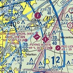
| Sectional chart |
|---|
|
| Airport distance calculator |
|---|
|
|
| Sunrise and sunset |
|---|
|
Times for 09-Oct-2025
| | Local
(UTC-4) | | Zulu
(UTC) |
|---|
| Morning civil twilight | | 06:37 | | 10:37 |
| Sunrise | | 07:05 | | 11:05 |
| Sunset | | 18:29 | | 22:29 |
| Evening civil twilight | | 18:56 | | 22:56 |
|
| Current date and time |
|---|
| Zulu (UTC) | 09-Oct-2025 17:04:52 |
|---|
| Local (UTC-4) | 09-Oct-2025 13:04:52 |
|---|
|
| METAR |
|---|
| KVAY | ASOS 119.325 609-267-1176
091654Z AUTO 36010G15KT 10SM CLR 16/03 A3044 RMK AO2 SLP307 T01610033
|
KPNE
12nm NW | 091654Z 04007G14KT 10SM CLR 16/03 A3046 RMK AO2 SLP313 T01610028
|
KWRI
13nm E | 091355Z AUTO 03012KT 10SM CLR 14/06 A3042 RMK AO2 SLP301 T01400056
|
KPHL
18nm W | 091654Z 04007KT 020V090 10SM FEW045 17/03 A3044 RMK AO2 SLP309 T01720028 PNO $
|
|
| TAF |
|---|
KPNE
12nm NW | 091442Z 0915/1012 02010G20KT P6SM SKC FM092300 04004KT P6SM SKC
|
KWRI
13nm E | 091000Z 0910/1016 34006KT 9999 SKC QNH3030INS BECMG 0914/0915 35010G15KT 9999 FEW060 QNH3034INS BECMG 1001/1002 VRB06KT 9999 FEW060 QNH3033INS TX21/0918Z TN07/1010Z
|
KPHL
18nm W | 091441Z 0915/1018 02010G20KT P6SM SKC FM092300 04004KT P6SM SKC FM101400 08005KT P6SM FEW040
|
|
| NOTAMs |
|---|
NOTAMs are issued by the DoD/FAA and will open in a separate window not controlled by AirNav.
|
|


