FAA INFORMATION EFFECTIVE 12 JUNE 2025
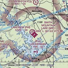
Location
| FAA Identifier: | W91 |
| Lat/Long: | 37-06-27.8000N 079-35-32.9000W
37-06.463333N 079-35.548333W
37.1077222,-79.5924722
(estimated) |
| Elevation: | 892.2 ft. / 271.9 m (surveyed) |
| Variation: | 09W (2010) |
| From city: | 4 miles SE of MONETA, VA |
| Time zone: | UTC -4 (UTC -5 during Standard Time) |
| Zip code: | 24121 |
Airport Operations
| Airport use: | Open to the public |
| Activation date: | 03/1962 |
| Control tower: | no |
| ARTCC: | WASHINGTON CENTER |
| FSS: | LEESBURG FLIGHT SERVICE STATION |
| NOTAMs facility: | DCA (NOTAM-D service available) |
| Attendance: | CONTINUOUS |
| Wind indicator: | yes |
| Segmented circle: | no |
| Lights: | ACTVT MIRL RWY 05/23 - CTAF. PAUSE 1 SECOND BETWEEN CLICKS. |
| Beacon: | white-green (lighted land airport)
Operates sunset to sunrise. |
Airport Communications
| CTAF/UNICOM: | 122.975 |
| ROANOKE APPROACH: | 135.0 |
| ROANOKE DEPARTURE: | 135.0 |
| IC: | 135.0 |
Nearby radio navigation aids
| VOR radial/distance | | VOR name | | Freq | | Var |
|---|
| LYHr248/19.2 | | LYNCHBURG VOR/DME | | 109.20 | | 05W |
| ROAr126/26.9 | | ROANOKE VOR/DME | | 109.40 | | 04W |
| SBVr318/38.0 | | SOUTH BOSTON VORTAC | | 110.40 | | 05W |
| NDB name | | Hdg/Dist | | Freq | | Var | | ID |
|---|
| VINTON | | 121/15.0 | | 277 | | 08W | | VIT | ...- .. - |
| TECH | | 107/39.2 | | 368 | | 08W | | TEC | - . -.-. |
Airport Services
| Fuel available: | 100LL
100LL:24-HR SELF-SERVE FUEL AVAILABLE WITH CREDIT CARD. |
| Parking: | tiedowns |
| Airframe service: | MAJOR |
| Powerplant service: | MAJOR |
| Bottled oxygen: | NONE |
| Bulk oxygen: | NONE |
Runway Information
Runway 5/23
| Dimensions: | 3058 x 50 ft. / 932 x 15 m |
| Surface: | asphalt, in fair condition |
| Weight bearing capacity: | | PCN 45 /F/D/Z/U | | Single wheel: | 3.0 | | Double wheel: | 3.0 | | Double tandem: | 3.0 | | Dual double tandem: | 3.0 |
|
| Runway edge lights: | medium intensity |
| Runway edge markings: | RWY 23 MRKGS WRONG RWY WIDTH. |
| RUNWAY 5 | | RUNWAY 23 |
| Latitude: | 37-06.285267N | | 37-06.641983N |
| Longitude: | 079-35.770783W | | 079-35.326567W |
| Elevation: | 854.7 ft. | | 892.0 ft. |
| Traffic pattern: | left | | left |
| Runway heading: | 054 magnetic, 045 true | | 234 magnetic, 225 true |
| Displaced threshold: | 250 ft. | | no |
| Markings: | NSTD, in good condition | | NSTD, in good condition |
| Runway end identifier lights: | no | | no |
| Touchdown point: | yes, no lights | | yes, no lights |
| Obstructions: | 43 ft. trees, 290 ft. from runway, 127 ft. right of centerline, 2:1 slope to clear
RY 05 HAS +12 FT ROAD AT THLD 100 FT R. PWR POLE 128 FT RIGHT OF APCH 86 FT FM THLD. | | 23 ft. tree, 238 ft. from runway, 122 ft. left of centerline, 1:1 slope to clear |
Airport Ownership and Management from official FAA records
| Ownership: | Privately-owned |
| Owner: | SMITH MOUNTAIN LAKE AIRPORT, LLC.
1090 CUTLASS RD
MONETA, VA 24121
Phone 540-297-4859 |
| Manager: | MOE BAZAZAN
1090 CUTLASS RD
MONETA, VA 24121
Phone 540-297-4859 |
Additional Remarks
| A39-05/23 | 50 YEARS OLD ASPHALT |
| - | DEER ON & INVOF ARPT. |
| - | ROA TWR SVCS AVBL AT 540-563-1307. |
| - | LNDG FEE FOR ALL ACFT OVR 5500 LBS PUBLISHED MAX GW AND ALL CHARTER FLIGHTS. |
| - | CLSD TO TRANSIENT PRACTICE LANDINGS. CLSD TO TRANSIENT ACFT PERFORMING TGL AND PLA. |
Instrument Procedures
NOTE: All procedures below are presented as PDF files. If you need a reader for these files, you should download the free Adobe Reader.NOT FOR NAVIGATION. Please procure official charts for flight.
FAA instrument procedures published for use from 12 June 2025 at 0901Z to 10 July 2025 at 0900z.
IAPs - Instrument Approach Procedures |
|---|
| RNAV (GPS) RWY 23 | |
download (199KB) |
| NOTE: Special Take-Off Minimums/Departure Procedures apply | |
download |
Other nearby airports with instrument procedures:
W90 - New London Airport (16 nm NE)
KROA - Roanoke-Blacksburg Regional Airport/Woodrum Field (22 nm NW)
KLYH - Lynchburg Regional Airport/Preston Glenn Field (23 nm NE)
0V4 - Brookneal/Campbell County Airport (28 nm E)
W24 - Falwell Airport (28 nm NE)
|
|

Road maps at:
MapQuest
Bing
Google
| Aerial photo |
|---|
WARNING: Photo may not be current or correct
 Photo by Moe
Photo taken 23-May-2015
looking west.
Photo by Moe
Photo taken 23-May-2015
looking west.
Do you have a better or more recent aerial photo of Smith Mountain Lake Airport that you would like to share? If so, please send us your photo.
|
| Sectional chart |
|---|
|
| Airport distance calculator |
|---|
|
|
| Sunrise and sunset |
|---|
|
Times for 16-Jun-2025
| | Local
(UTC-4) | | Zulu
(UTC) |
|---|
| Morning civil twilight | | 05:28 | | 09:28 |
| Sunrise | | 05:59 | | 09:59 |
| Sunset | | 20:39 | | 00:39 |
| Evening civil twilight | | 21:10 | | 01:10 |
|
| Current date and time |
|---|
| Zulu (UTC) | 16-Jun-2025 23:35:25 |
|---|
| Local (UTC-4) | 16-Jun-2025 19:35:25 |
|---|
|
| METAR |
|---|
KROA
22nm NW | 162317Z 13010KT 10SM OVC022 24/21 A3002 RMK AO2 T02390211
|
KLYH
23nm NE | 162313Z 03006KT 10SM BKN010 BKN017 OVC055 23/21 A3001 RMK AO2 RAE12 P0000 T02280211
|
K0V4
28nm E | 162315Z AUTO 08009KT 5SM SCT070 OVC100 23/22 A3000 RMK AO1
|
KDAN
35nm S | 162253Z AUTO 00000KT 10SM FEW070 FEW085 26/24 A2998 RMK AO2 LTG DSNT SE AND S RAE34 TSE2154 SLP141 P0004 T02560244
|
KMTV
36nm SW | 162315Z AUTO 18004KT 10SM CLR 26/21 A3002 RMK AO2 LTG DSNT SE AND NW T02550210
|
KBCB
40nm W | 162315Z AUTO 10006KT 10SM SCT100 25/21 A3007 RMK AO2 LTG DSNT N AND SE T02470209
|
KSIF
42nm S | 162315Z AUTO 00000KT 10SM SCT014 25/24 A3000 RMK AO2 T02530235
|
KW78
43nm SE | 162315Z AUTO 00000KT 10SM BKN060 BKN070 A2999 RMK AO1
|
|
| TAF |
|---|
KROA
22nm NW | 162109Z 1621/1718 15008KT P6SM VCTS SCT017 BKN030CB TEMPO 1621/1624 6SM -SHRA BKN017 FM170000 10004KT 4SM -SHRA BR SCT009 OVC017 TEMPO 1700/1703 2SM TSRA BR OVC009CB FM170400 00000KT 3SM BR SCT005 OVC014 FM170600 00000KT 3SM BR OVC002 FM171300 00000KT 5SM BR BKN007 FM171500 VRB03KT P6SM BKN020
|
KLYH
23nm NE | 162128Z 1621/1718 08006KT P6SM VCSH BKN016 FM170100 05004KT 4SM SHRA BR VCTS SCT004 BKN018CB FM170400 03003KT 3SM BR VCSH OVC003 FM171400 00000KT 5SM BR BKN003 FM171600 21005KT P6SM BKN040
|
|
| NOTAMs |
|---|
NOTAMs are issued by the DoD/FAA and will open in a separate window not controlled by AirNav.
|
|


