FAA INFORMATION EFFECTIVE 15 MAY 2025
Location
| FAA Identifier: | 63B |
| Lat/Long: | 43-45-46.9000N 070-40-20.9000W
43-45.781667N 070-40.348333W
43.7630278,-70.6724722
(estimated) |
| Elevation: | 292.3 ft. / 89.1 m (surveyed) |
| Variation: | 17W (1985) |
| From city: | 3 miles N of LIMINGTON, ME |
| Time zone: | UTC -4 (UTC -5 during Standard Time) |
| Zip code: | 04049 |
Airport Operations
| Airport use: | Open to the public |
| Activation date: | 09/1975 |
| Control tower: | no |
| ARTCC: | BOSTON CENTER |
| FSS: | BANGOR FLIGHT SERVICE STATION |
| NOTAMs facility: | BGR (NOTAM-D service available) |
| Attendance: | UNATNDD |
| Pattern altitude: | 1392.3 ft. MSL |
| Wind indicator: | lighted |
| Segmented circle: | no |
| Lights: | ACTVT LIRL RWY 11/29 5 CLICKS - CTAF. |
Airport Communications
| CTAF/UNICOM: | 122.7 |
| PORTLAND APPROACH: | 119.75 |
| PORTLAND DEPARTURE: | 119.75 |
| WX ASOS at PWM (17 nm SE): | 119.05 (207-874-7914) |
| WX ASOS at IZG (18 nm NW): | 135.775 (207-935-2882) |
Nearby radio navigation aids
| VOR radial/distance | | VOR name | | Freq | | Var |
|---|
| ENEr010/20.4 | | KENNEBUNK VOR/DME | | 117.10 | | 17W |
| NDB name | | Hdg/Dist | | Freq | | Var | | ID |
|---|
| ROLLINS | | 028/33.3 | | 260 | | 16W | | ESG | . ... --. |
Airport Services
| Fuel available: | 100LL
100LL:24 HR SELF-SERVE FUEL WITH MAJOR CREDIT CARD. |
| Parking: | hangars and tiedowns |
| Airframe service: | NONE |
| Powerplant service: | NONE |
Runway Information
Runway 11/29
| Dimensions: | 2973 x 50 ft. / 906 x 15 m |
| Surface: | asphalt, in poor condition
SVRLY CRACKED, SHALLOW POTHOLES, LOOSE AGGRETATE ON RWY. |
| Runway edge lights: | non-standard
NON-STD LIRL. RWY 29 HAS ONE THR LGT 175 FT FM THR, RWY 11 HAS TWO THR LGTS 320 FT FM THR, RWY LGTS SPACED AT 400 FT, MANY LGTS MISG. |
| Runway edge markings: | MKD AS BASIC, NRS DSPLCD 167 FT FM THR, NRS & CNTRLN FADED. |
| RUNWAY 11 | | RUNWAY 29 |
| Latitude: | 43-45.794253N | | 43-45.769358N |
| Longitude: | 070-40.685082W | | 070-40.010848W |
| Elevation: | 292.3 ft. | | 279.1 ft. |
| Traffic pattern: | left | | left |
| Runway heading: | 110 magnetic, 093 true | | 290 magnetic, 273 true |
| Markings: | basic, in poor condition | | basic, in poor condition |
| Touchdown point: | yes, no lights | | yes, no lights |
| Obstructions: | 25 ft. trees, 201 ft. from runway, 140 ft. both sides of centerline
+2 FT -20 FT BRUSH & TREES 0-200 FT FM THR, 0 FT B; +3 FT -5 FT DITCH 0-200 FT FM THR, 50 FT R OF CNTRLN. | | 55 ft. trees, 327 ft. from runway, 125 ft. right of centerline, 2:1 slope to clear
+15 FT ROAD 50-200 FT FM THR 0-125 FT R; +25 FT POLE 50 FT FM THR 100 FT R; +35 FT PWR LINE 0-200 FT FM THR, 125 FT R; FUEL TANK 0 FT FM THR, 125 FT R. |
Airport Ownership and Management from official FAA records
| Ownership: | Privately-owned |
| Owner: | STARKWEATHER AIRPORT AUTHORITY, LLC
P.O. BOX 94
ROCHESTER, NH 03868
Phone 207-200-7548 |
| Manager: | KYLE STARKWEATHER
12 CROWHILL RD
ROCHESTER, NH 03868
Phone 207-200-7548 |
Additional Remarks
| - | WILDLIFE ON OR INVOF ARPT. |
| - | FOR CD CTC PORTLAND APCH AT 207-874-7320, WHEN APCH CLSD CTC BOSTON ARTCC AT 603-879-6859. |
Instrument Procedures
There are no published instrument procedures at 63B.
Some nearby airports with instrument procedures:
KPWM - Portland International Jetport (17 nm SE)
KIZG - Eastern Slopes Regional Airport (18 nm NW)
B19 - Biddeford Municipal Airport (20 nm SE)
KSFM - Sanford Seacoast Regional Airport (22 nm S)
KLEW - Auburn/Lewiston Municipal Airport (24 nm NE)
|
|

Road maps at:
MapQuest
Bing
Google
| Aerial photo |
|---|
WARNING: Photo may not be current or correct
 Photo by Pete Chaisson- Portland Flight Services
Photo taken 25-Sep-2014
looking southwest.
Photo by Pete Chaisson- Portland Flight Services
Photo taken 25-Sep-2014
looking southwest.
Do you have a better or more recent aerial photo of Limington-Harmon Airport that you would like to share? If so, please send us your photo.
|
| Sectional chart |
|---|
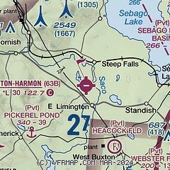
|
| Airport distance calculator |
|---|
|
|
| Sunrise and sunset |
|---|
|
Times for 28-May-2025
| | Local
(UTC-4) | | Zulu
(UTC) |
|---|
| Morning civil twilight | | 04:32 | | 08:32 |
| Sunrise | | 05:07 | | 09:07 |
| Sunset | | 20:13 | | 00:13 |
| Evening civil twilight | | 20:48 | | 00:48 |
|
| Current date and time |
|---|
| Zulu (UTC) | 29-May-2025 00:45:39 |
|---|
| Local (UTC-4) | 28-May-2025 20:45:39 |
|---|
|
| METAR |
|---|
KPWM
18nm SE | 282351Z 19010G17KT 10SM CLR 20/09 A3015 RMK AO2 SLP209 T02000094 10244 20194 56006
|
KIZG
18nm NW | 282354Z AUTO 19006KT 10SM CLR 23/07 A3013 RMK AO2 SLP203 T02330072 10294 20233 55002
|
KSFM
23nm S | 282356Z AUTO VRB04KT 10SM CLR 21/09 A3016 RMK AO2 SLP216 T02110094 10272 20211 56002
|
KLEW
24nm NE | 282356Z AUTO 19007KT 10SM CLR 22/09 A3014 RMK AO2 SLP212 6//// T02220094 10278 20222 55002 PNO $
|
KDAW
31nm S | 282351Z AUTO 17004KT 10SM 22/11 A3015 RMK AO2 SLP207 T02170111 10289 20217 55001 $
|
KBXM
33nm E | 290035Z AUTO 20015KT 10SM CLR 17/09 A3017 RMK AO2
|
KLCI
34nm W | 282356Z AUTO 19007KT 10SM CLR 23/07 A3015 RMK AO2 SLP208 T02280067 10267 20228 55002
|
|
| TAF |
|---|
KPWM
18nm SE | 281733Z 2818/2918 19008KT P6SM BKN250 FM291500 20008KT P6SM BKN025
|
|
| NOTAMs |
|---|
NOTAMs are issued by the DoD/FAA and will open in a separate window not controlled by AirNav.
|
|


